Research Team Forecasted Beach Impacts from Hurricane Idalia
USGS and NOAA partner to continually improve coastal change forecasts
Hawaiian Volcano Observatory Deploys New Equipment on Kīlauea Summit
New webcam and more
Alarming Future for California's Coastline
Computer modeling and new research predict significant erosion by 2100
New USGS-FEMA study highlights economic earthquake risk in the United States
Natural Hazards Mission Area
Every year in the United States, natural hazards threaten lives and livelihoods and result in billions of dollars in damage. We work with many partners to monitor, assess, and conduct targeted research on a wide range of natural hazards so that policymakers and the public have the understanding they need to enhance preparedness, response, and resilience.
Reducing Risk

USGS scientists develop new products to make science available to the public, emergency managers, and decision-makers. These efforts increase public safety and reduce risk and economic losses caused by natural hazards.
Subduction Zone Science
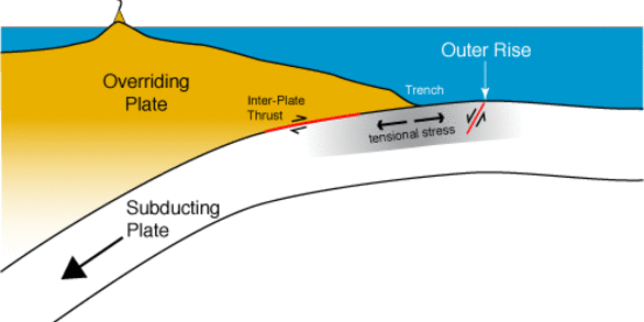
The most powerful earthquakes, tsunamis, landslides, and volcanic eruptions occur in subduction zones, where two plates collide and one is thrust beneath another.
Get Notified
You can subscribe to USGS Hazards Data Alerts, Forecasts and other Earth Monitoring Information