
Rapid Response Seafloor Seismology
New Small Ocean-Bottom Seismographs Enable Rapid Response to Earthquakes and Other Marine Geohazards
Ocean-bottom seismographs are valuable tools for studying marine geohazards like subduction zone earthquakes. The USGS has partnered with the Woods Hole Oceanographic Institution to operate a small fleet of highly mobile instruments to deploy during periods of seismic unrest.
Offshore Seismic Science
Major marine geohazards, such as earthquakes, submarine landslides, tsunamis, and volcanoes, can threaten lives and critical infrastructure both at sea and on land. For the last several decades, USGS has been studying the historical impact of these hazards, as well as forecasting future risks in the regions where they occur. This includes developing hazard maps and models that help engineers, policymakers, and other decision makers mitigate risks to people and property.
One tool in our scientific arsenal is the use of ocean-bottom seismographs. These are a type of seismograph that can be deployed on the seafloor for weeks, months, and even years to record shaking from seismic waves. Placing the instruments offshore helps us more accurately locate and measure the magnitude of underwater and remote earthquakes.


Meeting a Crucial Need
Traditional ocean-bottom seismographs can weigh many hundreds of pounds and require large research vessels to transport them tens to hundreds of miles out to sea. While those instruments are well-suited for long-term research, they are large, cumbersome, and expensive to deploy. This limits their effectiveness for rapidly responding to earthquakes, volcanic eruptions, and other marine geohazards. Typically, it takes months for them to be shipped to a port, loaded on a ship, and finally deployed—meaning we would miss out on critical first few weeks to months of seismic data. To address the need for more mobile equipment, the USGS partnered with the Ocean Bottom Seismic Instrument Center at the Woods Hole Oceanographic Institution to maintain and operate a fleet of small ocean-bottom seismographs dedicated to rapid-response efforts.

“A magnitude 7.4 earthquake shook Taiwan the morning after we finished an open-water test of the new instruments,” said Dr. Nathan Miller, USGS research geophysicist. “That was a timely reminder that big earthquakes can happen anytime. If we want to record aftershocks offshore, we have to have instruments ready to go.”


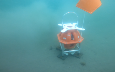
Small Ocean-Bottom Seismographs
The new ocean-bottom seismographs record shaking with an accelerometer. Similar to the computer chips that measure motion in smartphones, this finger-nail-sized sensor can measure shaking in any orientation, removing the need for the large, complex, and power-consuming leveling systems used by traditional seafloor instruments. Combining the accelerometer with low-power recording electronics means the new instruments need less battery power, further reducing the size and weight of the instruments.
The fleet currently has 10 instruments that measure 24 by 24 inches and weigh about 50 pounds. The instruments can be deployed for about 50 days in water up to ~4 miles deep. By having a fleet of instruments designed for rapid response, we can record events during periods of exceptionally high scientific value, for a fraction of the cost of long-term deployments.
The new instruments were successfully tested offshore in Cape Cod, Massachusetts in April 2024. A response plan for providing on-call staff and equipment for rapid deployments offshore California, the Pacific Northwest, Alaska, and the Caribbean is being developed by the USGS and Woods Hole Oceanographic Institution. The goal is to be able to mobilize and deploy the fleet within 2 weeks of marine seismic events.
The new fleet represents a significant advancement in rapid response capabilities for marine geohazards research. This next-generation fleet can provide high-value data to the scientific community and help enhance our understanding of seismic and other geohazards.

Get Our News
These items are in the RSS feed format (Really Simple Syndication) based on categories such as topics, locations, and more. You can install and RSS reader browser extension, software, or use a third-party service to receive immediate news updates depending on the feed that you have added. If you click the feed links below, they may look strange because they are simply XML code. An RSS reader can easily read this code and push out a notification to you when something new is posted to our site.