
USGS Science Collaboration Portal for the Colorado River Basin
Collaboration platform that brings together science, data, and mapping and analytical tools from across the basin
Collaboration platform that brings together science, data, and mapping and analytical tools from across the basin
Colorado River Basin Actionable and Strategic Integrated Science and Technology (ASIST) Initiative
Fostering Innovative Interdisciplinary Science for Characterizing and Adapting to Long-term Drought
Fostering Innovative Interdisciplinary Science for Characterizing and Adapting to Long-term Drought
Colorado River Basin Drought and the 2023 Water Year
Geonarrative presentation comparing 2023 conditions to the long-term drought in the Colorado River Basin
Geonarrative presentation comparing 2023 conditions to the long-term drought in the Colorado River Basin
Great Salt Lake Data and Reports by the USGS
Learn about Water Quantity and Quality and Aquatic Ecology of this National Treasure
Learn about Water Quantity and Quality and Aquatic Ecology of this National Treasure
Colorado River Basin Studies in Utah
Learn about Surface Water, Groundwater Quantities and Quality and Artificial Recharge of Groundwater in the Colorado River Basin in Utah
Learn about Surface Water, Groundwater Quantities and Quality and Artificial Recharge of Groundwater in the Colorado River Basin in Utah
Streamflow in the Upper Rio Grande Basin
USGS Analyses of the Effects of Potential Future Climate Conditions on Streamflows in the Upper Rio Grande Basin
USGS Analyses of the Effects of Potential Future Climate Conditions on Streamflows in the Upper Rio Grande Basin
Next Generation Water Observing System (NGWOS) Study: Upper Colorado River Basin
The USGS NGWOS Program Provides Innovative, High-fidelity, Real-time Data and Insightful Analyses about Water Quantity, Quality, and Use in Selected Watersheds across the U.S.
The USGS NGWOS Program Provides Innovative, High-fidelity, Real-time Data and Insightful Analyses about Water Quantity, Quality, and Use in Selected Watersheds across the U.S.
Rocky Mountain Region
U.S. Geological Survey (USGS) Region 7: Upper Colorado Basin includes the States of Colorado, New Mexico, Utah, and Wyoming. USGS Science Centers conduct interdisciplinary research and monitoring related to natural resources, ecology, climate, and natural hazards. Data, analyses, and tools developed by USGS staff help stakeholders to make sustainable management decisions.
USGS Region 7: Upper Colorado Basin (Rocky Mountain)
USGS Region 7: Upper Colorado Basin (Rocky Mountain)
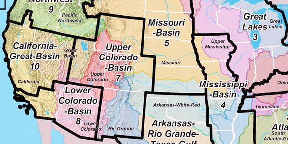
Map Showing USGS/DOI Unified Region 7 and adjoining Regions
Additional Information about USGS Region 7
Additional Information about USGS Region 7
News
Media Alert: USGS Dye-Tracing Study in Lake Fork Creek to Map Groundwater Flow
Media Alert: USGS Dye-Tracing Study in Lake Fork Creek to Map Groundwater Flow
Think regionally, act locally: Perspectives on co-design of spatial conservation prioritization tools
Think regionally, act locally: Perspectives on co-design of spatial conservation prioritization tools
USGS Scientists Deploy to New Mexico Fire to Enhance Water Monitoring
USGS Scientists Deploy to New Mexico Fire to Enhance Water Monitoring
Publications
Assessment of undiscovered conventional oil and gas resources of the Black Sea area, 2023
Using a geology-based assessment methodology, the U.S. Geological Survey estimated undiscovered, technically recoverable mean resources of 2.3 billion barrels of oil and 105.5 trillion cubic feet of gas in the Black Sea area.
Think regionally, act locally: Perspectives on co-design of spatial conservation prioritization tools and why end-user engagement altered our approach
Coproduction represents an inclusive approach for developing decision-support resources because it seeks to integrate scientific knowledge and end-user needs. Unfortunately, spatial decision support systems (SDSS) coproduction has sometimes resulted in limited utility for end-users, partially due to scarce SDSS coproduction guidance. To initiate coproduction, we held a series of workshops to co-de
Isotopic evaluation of the National Water Model reveals missing agricultural irrigation contributions to streamflow across the western United States
The National Water Model (NWM) provides critical analyses and projections of streamflow that support water management decisions. However, the NWM performs poorly in lower-elevation rivers of the western United States (US). The accuracy of the NWM depends on the fidelity of the model inputs and the representation and calibration of model processes and water sources. To evaluate the NWM performance
Science
Prioritizing restoration and conservation of Wyoming’s sagebrush ecosystems for wildlife and sagebrush connectivity
To support strategic ecosystem management across the imperiled sagebrush steppe in Wyoming, USA, we developed an extension of the Prioritizing Restoration of Sagebrush Ecosystems Tool (PReSET). Our expanded tool leverages emerging spatial data resources to provide a structured but customizable set of scenarios that can guide landscape-scale planning efforts by prioritizing conservation and...

Prioritizing restoration and conservation of sagebrush ecosystems in northwestern Colorado
We are working with Colorado Parks and Wildlife (CPW) to pilot an expansion of the Prioritizing Restoration of Sagebrush Ecosystems Tool (PReSET; Duchardt et al. 2021) across northwestern Colorado. We are in the initial phase of a two-phase project where we are leveraging existing data resources to provide customized scenarios that directly guide landscape-scale conservation delivery by CPW. This...
Gunnison Sage-grouse Prioritizing Restoration of Sagebrush Ecosystems Tool (PReSET)
In partnership with the United States Fish and Wildlife Service, and other partners, scientists from USGS Fort Collins Science Center are working to create a suite of prioritization scenarios that will inform adaptive management for Gunnison sage-grouse.