

A before-and-after image showing the change in edits between 10/28/21 and 11/04/21. Volunteers edited over 400 points during this timeframe (public domain).
Before and After Images
The USGS has science based work that often requires the comparison of two geographic areas over time. Though scientific data is critical to understanding changes over time, visually seeing those changes is a powerful tool in support of that data.
Filter Total Items: 323
TNMCorps Mapping Challenge: Cemeteries in Western TN as of 11/04/21
A before-and-after image showing the change in edits between 10/28/21 and 11/04/21. Volunteers edited over 400 points during this timeframe (public domain).

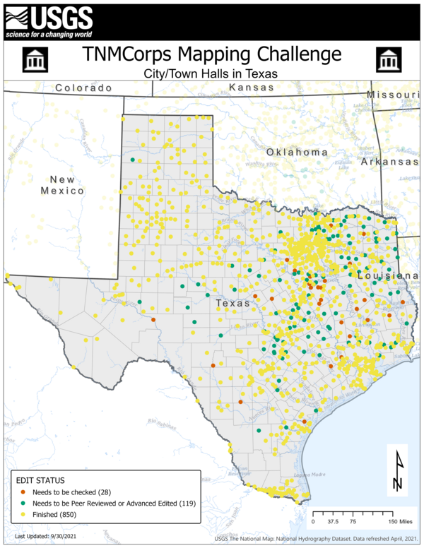
TNMCorps Mapping Challenge: City/Town Halls in TX as of 11/04/21
A before-and-after image showing the change in edits between 10/28/21 and 11/04/21. This challenge is now finished (public domain).
A before-and-after image showing the change in edits between 10/28/21 and 11/04/21. This challenge is now finished (public domain).
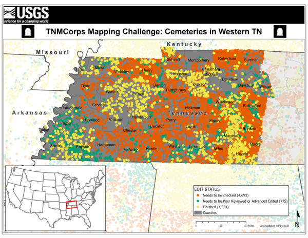
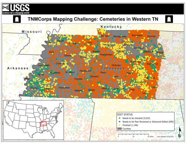
TNMCorps Mapping Challenge: Edits to Cemeteries in Western TN as of 10/19/21
A before-and-after image showing the change in edits between 10/14/21 and 10/19/21. Volunteers edited almost 300 new points during this timeframe (public domain).
A before-and-after image showing the change in edits between 10/14/21 and 10/19/21. Volunteers edited almost 300 new points during this timeframe (public domain).
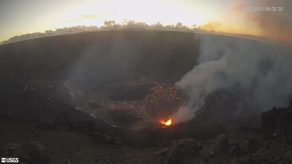
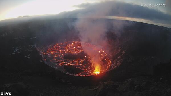
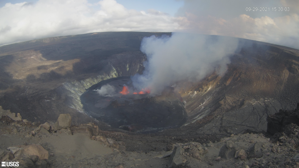
Recent changes at Kīlauea volcano - October 7, 2021
The USGS Hawaiian Volcano Observatory KWcam at Kīlauea's summit has captured changes within Halemaʻumaʻu crater, at Kīlauea's summit, due to the eruption that began on September 29, 2021. At approximately 3:21 pm, HST, new fissures opened at the base of Halemaʻumaʻu crater.
The USGS Hawaiian Volcano Observatory KWcam at Kīlauea's summit has captured changes within Halemaʻumaʻu crater, at Kīlauea's summit, due to the eruption that began on September 29, 2021. At approximately 3:21 pm, HST, new fissures opened at the base of Halemaʻumaʻu crater.
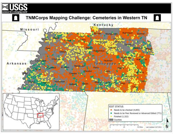
TNMCorps Mapping Challenge: Cemeteries in Western TN as of 10/14/21
A before-and-after image showing the change in edits between 10/07/21 and 10/14/21. Volunteers edited over 200 points during this timeframe (public domain).
A before-and-after image showing the change in edits between 10/07/21 and 10/14/21. Volunteers edited over 200 points during this timeframe (public domain).
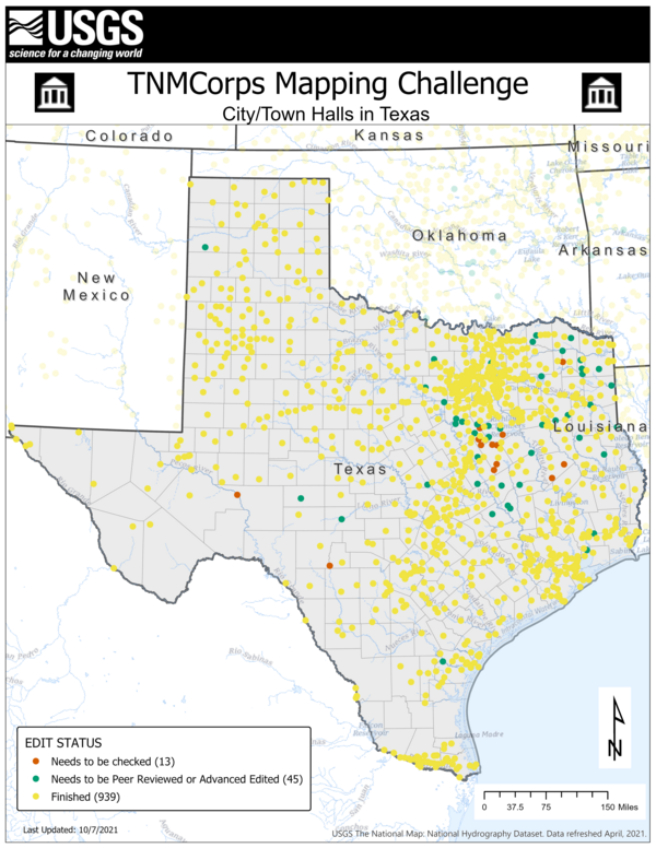
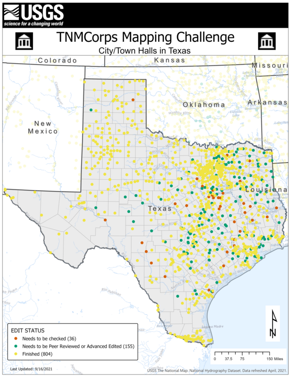
TNMCorps Mapping Challenge: City/Town Halls in TX as of 10/14/21
A before-and-after image showing the change in edits between 10/07/21 and 10/14/21. Volunteers edited almost 100 points during this timeframe (public domain).
A before-and-after image showing the change in edits between 10/07/21 and 10/14/21. Volunteers edited almost 100 points during this timeframe (public domain).

TNMCorps Mapping Challenge: Law Enforcement in KS & OK as of 10/14/21
A before-and-after image showing the change in edits between 10/07/21 and 10/14/21. This challenge is now complete (public domain).
A before-and-after image showing the change in edits between 10/07/21 and 10/14/21. This challenge is now complete (public domain).
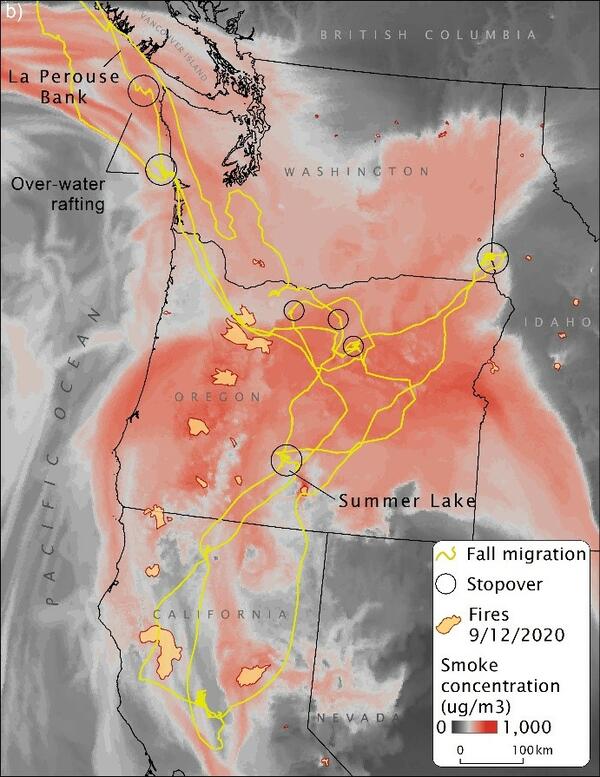
Tule Goose Migration Tracks, 2019 and 2020
Fall migration routes for tule geese in 2019 (five geese) and 2020 (four geese) through arrival at Summer Lake Wildlife Area, Oregon. This area experienced massive wildfires in 2020 which resulted in aberrant migration behavior, increased energetic demands, and increased mortality risk.
Fall migration routes for tule geese in 2019 (five geese) and 2020 (four geese) through arrival at Summer Lake Wildlife Area, Oregon. This area experienced massive wildfires in 2020 which resulted in aberrant migration behavior, increased energetic demands, and increased mortality risk.
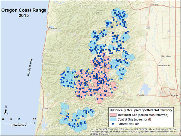
Interactive before/after image of barred owl sightings
Use the green slider tool in the center to view locations of barred owl sightings recorded during 2015 and 2020 owl monitoring activities at the Oregon Coast Range study area.
Use the green slider tool in the center to view locations of barred owl sightings recorded during 2015 and 2020 owl monitoring activities at the Oregon Coast Range study area.
Recent changes at Kīlauea volcano
The USGS Hawaiian Volcano Observatory KWcam at Kīlauea's summit has captured changes within Halemaʻumaʻu crater, at Kīlauea's summit, due to the eruption that began on September 29, 2021. At approximately 3:21 pm, HST, new fissures opened at the base of Halemaʻumaʻu crater.
The USGS Hawaiian Volcano Observatory KWcam at Kīlauea's summit has captured changes within Halemaʻumaʻu crater, at Kīlauea's summit, due to the eruption that began on September 29, 2021. At approximately 3:21 pm, HST, new fissures opened at the base of Halemaʻumaʻu crater.
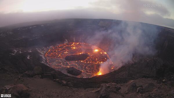
Recent changes at Kīlauea volcano - October 4, 2021
The USGS Hawaiian Volcano Observatory KWcam at Kīlauea's summit has captured changes within Halemaʻumaʻu crater, at Kīlauea's summit, due to the eruption that began on September 29, 2021. At approximately 3:21 pm, HST, new fissures opened at the base of Halemaʻumaʻu crater.
The USGS Hawaiian Volcano Observatory KWcam at Kīlauea's summit has captured changes within Halemaʻumaʻu crater, at Kīlauea's summit, due to the eruption that began on September 29, 2021. At approximately 3:21 pm, HST, new fissures opened at the base of Halemaʻumaʻu crater.
TNMCorps Mapping Challenge: Cemeteries in Western TN as of 10/07/21
A before-and-after image showing the change in edits between 9/30/21 and 10/07/21 (public domain).
A before-and-after image showing the change in edits between 9/30/21 and 10/07/21 (public domain).
TNMCorps Mapping Challenge: City/Town Halls in TX as of 10/07/21
A before-and-after image showing the change in edits between 9/30/21 and 10/07/21 (public domain).
A before-and-after image showing the change in edits between 9/30/21 and 10/07/21 (public domain).

TNMCorps Mapping Challenge: Law Enforcement in KS & OK as of 10/07/21
A before-and-after image showing the change in edits between 9/30/21 and 10/07/21 (public domain).
A before-and-after image showing the change in edits between 9/30/21 and 10/07/21 (public domain).
New eruption at Kīlauea Volcano - September 29, 2021
The USGS Hawaiian Volcano Observatory KWcam at Kīlauea's summit has captured the onset of a new eruption within Halemaʻumaʻu crater on September 29, 2021. At approximately 3:21 pm, HST, new fissures opened at the base of Halemaʻumaʻu crater.
The USGS Hawaiian Volcano Observatory KWcam at Kīlauea's summit has captured the onset of a new eruption within Halemaʻumaʻu crater on September 29, 2021. At approximately 3:21 pm, HST, new fissures opened at the base of Halemaʻumaʻu crater.
TNMCorps Mapping Challenge: City/Town Halls in TX as of 09/23/21
A before-and-after image showing the change in edits between 9/16/21 and 9/23/21 (public domain).
A before-and-after image showing the change in edits between 9/16/21 and 9/23/21 (public domain).

TNMCorps Mapping Challenge: City/Town Halls in TX as of 09/30/21
A before-and-after image showing the change in edits between 9/23/21 and 9/30/21. Almost 50 edits were contributed during this timeframe (public domain).
A before-and-after image showing the change in edits between 9/23/21 and 9/30/21. Almost 50 edits were contributed during this timeframe (public domain).
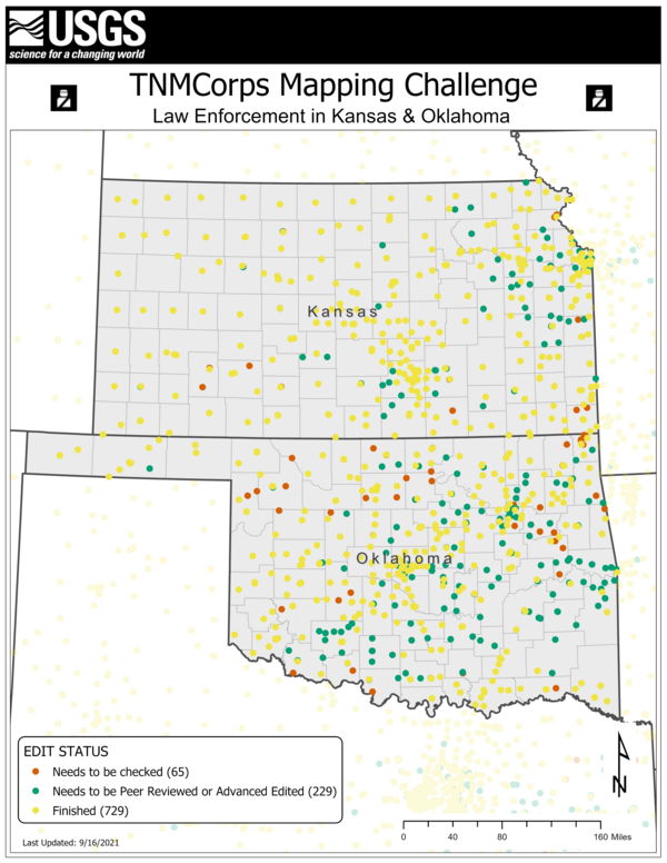
TNMCorps Mapping Challenge: Law Enforcement in KS & OK as of 09/23/21
A before-and-after image showing the change in edits between 9/16/21 and 9/23/21. Over 100 edits came in during this time period (public domain).
A before-and-after image showing the change in edits between 9/16/21 and 9/23/21. Over 100 edits came in during this time period (public domain).

TNMCorps Mapping Challenge: Law Enforcement in KS & OK as of 09/30/21
A before-and-after image showing the change in edits between 9/23/21 and 9/30/21 (public domain).
A before-and-after image showing the change in edits between 9/23/21 and 9/30/21 (public domain).
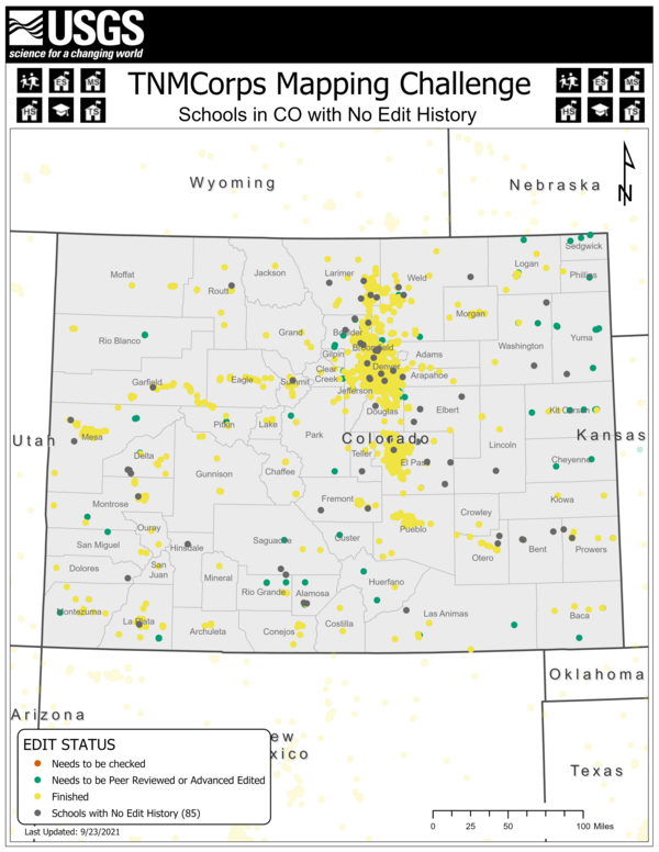
TNMCorps Mapping Challenge: Schools in CO NoHistory as of 09/30/21
A before-and-after image showing the change in edits between 9/23/21 and 9/30/21. Only 11 points with no edit history remain. This challenge is now complete (public domain).
A before-and-after image showing the change in edits between 9/23/21 and 9/30/21. Only 11 points with no edit history remain. This challenge is now complete (public domain).
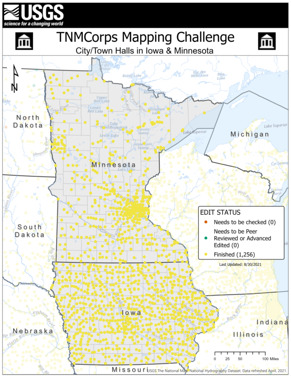
TNMCorps Mapping Challenge: City/Town Halls in IA, MN as of 09/09/21
A before-and-after image showing the change in edits between 8/30/21 and 9/09/21. Volunteers added almost 70 new points during this timeframe (public domain).
A before-and-after image showing the change in edits between 8/30/21 and 9/09/21. Volunteers added almost 70 new points during this timeframe (public domain).