
The Northeast Rift Zone eruption of Mauna Loa has continued into its third full day. At this time two fissures are active, sending lava flows primarily to the north-northeast.
Images
Explore our planet through photography and imagery, including climate change and water all the way back to the 1800s when the USGS was surveying the country by horse and buggy.
Filter Total Items: 21558

November 30, 2022 — Mauna Loa Eruption Map
The Northeast Rift Zone eruption of Mauna Loa has continued into its third full day. At this time two fissures are active, sending lava flows primarily to the north-northeast.

November 30, 2022 — Mauna Loa Fissure 3
Aerial image of fissure 3 on Mauna Loa's Northeast Rift Zone erupting the morning of November 30, 2022. Fissure 3 remains the dominant source of the largest lava flow being generated during the eruption. USGS image by K. Mulliken.
Aerial image of fissure 3 on Mauna Loa's Northeast Rift Zone erupting the morning of November 30, 2022. Fissure 3 remains the dominant source of the largest lava flow being generated during the eruption. USGS image by K. Mulliken.

November 30, 2022 — Mauna Loa Fissure 4
Aerial image of fissure 4 on Mauna Loa's Northeast Rift Zone erupting the morning of November 30, 2022. Fissure 4 is less active than fissure 3, but is generating lava flows moving toward the northeast and a small lobe moving to the east. USGS image by K. Mulliken.
Aerial image of fissure 4 on Mauna Loa's Northeast Rift Zone erupting the morning of November 30, 2022. Fissure 4 is less active than fissure 3, but is generating lava flows moving toward the northeast and a small lobe moving to the east. USGS image by K. Mulliken.

November 30, 2022 — Mauna Loa Lava Flow
Aerial image of the distal end of a lava flow from Mauna Loa's Northeast Rift Zone the morning of November 30, 2022. As of 12:30 HST p.m. on November 30, the flow front remained about 3.6 miles (5.8 km) from the Daniel K. Inouye Highway (Saddle Road). USGS image by K. Mulliken.
Aerial image of the distal end of a lava flow from Mauna Loa's Northeast Rift Zone the morning of November 30, 2022. As of 12:30 HST p.m. on November 30, the flow front remained about 3.6 miles (5.8 km) from the Daniel K. Inouye Highway (Saddle Road). USGS image by K. Mulliken.

November 30, 2022—Mauna Loa Northeast Rift Zone eruption thermal map
A helicopter overflight on November 30, 2022, allowed for aerial visual and thermal imagery to be collected of the Northeast Rift Zone eruption of Mauna Loa. Two active fissures on the Northeast Rift Zone are feeding lava flows to the north, northeast, and southeast.
A helicopter overflight on November 30, 2022, allowed for aerial visual and thermal imagery to be collected of the Northeast Rift Zone eruption of Mauna Loa. Two active fissures on the Northeast Rift Zone are feeding lava flows to the north, northeast, and southeast.
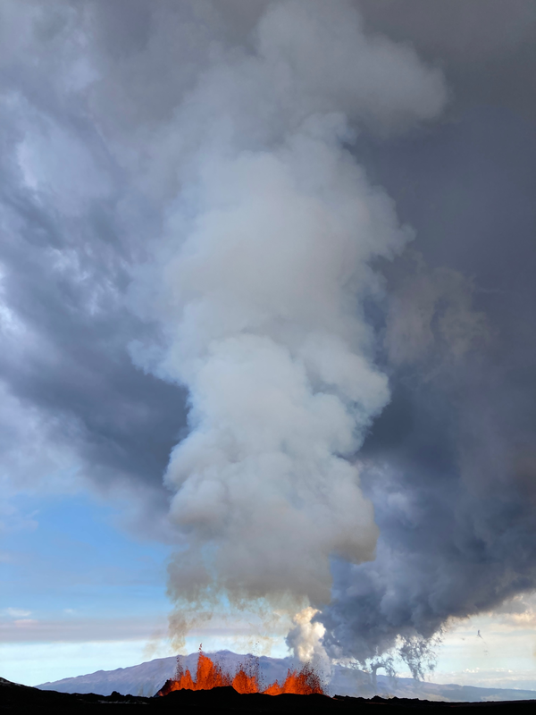
Vertical Plume from Fissure 3 of Mauna Loa (Nov 30, 2022)
Fissure 3 of the Northeast Rift Zone Mauna Loa eruption with a plume of volcanic gases and fine volcanic ash and Pele's hair being wafted in a near vertical plume. Taken at about 7:15 AM on November 30, 2022.
Fissure 3 of the Northeast Rift Zone Mauna Loa eruption with a plume of volcanic gases and fine volcanic ash and Pele's hair being wafted in a near vertical plume. Taken at about 7:15 AM on November 30, 2022.
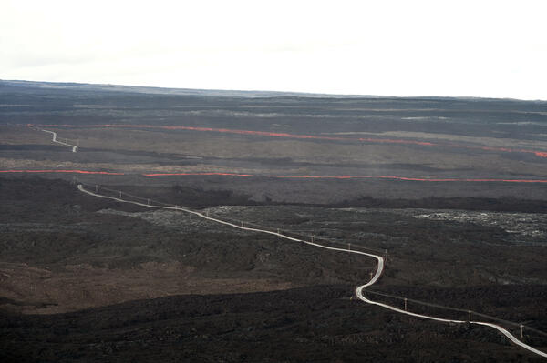
Lava flow cutting the Mauna Loa Observatory Road
This image was taken on a helicopter overflight on the afternoon of November 29, 2022. It shows a lava flow cutting across the Mauna Loa Observatory Road in two places. USGS image by L. Gallant.
This image was taken on a helicopter overflight on the afternoon of November 29, 2022. It shows a lava flow cutting across the Mauna Loa Observatory Road in two places. USGS image by L. Gallant.
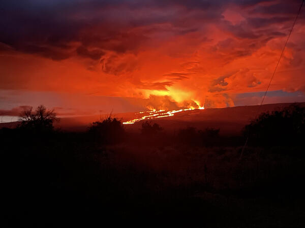
Mauna Loa eruption from the Northeast Rift Zone sends lava flows to the north downslope toward Saddle Road. As of 6am local time, flows were 6 miles from Saddle Road.
linkPhotograph taken from Saddle Road at 6AM Hawaii time on November 29, 2022 shows lava flows moving northeast downslope of Mauna Loa volcano from the Northeast Rift Zone eruption.

Mauna Loa eruption from the Northeast Rift Zone sends lava flows to the north downslope. As of 6am local time, flows were 6 miles from Saddle Road.
linkPhotograph taken from Saddle Road at 6AM Hawaii time on November 29, 2022 shows lava flows moving northeast downslope of Mauna Loa volcano from the Northeast Rift Zone eruption.

Mauna Loa fissure erupting on November 29, 2022
This image shows an erupting fissure high on Mauna Loa's Northeast Rift Zone. Fountain heights of 20-25 meters (65-82 feet) were measured by HVO field crews on the morning of November 29, 2022. USGS image by L. Gallant.
This image shows an erupting fissure high on Mauna Loa's Northeast Rift Zone. Fountain heights of 20-25 meters (65-82 feet) were measured by HVO field crews on the morning of November 29, 2022. USGS image by L. Gallant.

Mauna Loa fissure eruption and lava flow
An erupting fissure high on Mauna Loa's Northeast Rift Zone was issuing multiple lava flows on the morning of November 29, 2022. Fountain heights of 20-25 meters (65-82 feet) were measured by HVO field crews. A gas plume is rising off of the fissure and partially obscuring Mauna Kea in the background of the image. USGS image by L. Gallant.
An erupting fissure high on Mauna Loa's Northeast Rift Zone was issuing multiple lava flows on the morning of November 29, 2022. Fountain heights of 20-25 meters (65-82 feet) were measured by HVO field crews. A gas plume is rising off of the fissure and partially obscuring Mauna Kea in the background of the image. USGS image by L. Gallant.

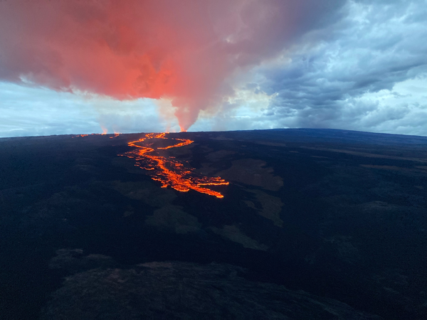
Mauna Loa flow front
This image, taken during a helicopter overflight on the afternoon of November 29, shows the advancing flow front from Mauna Loa. This flow was erupted from a vent high up on the Northeast Rift Zone and is flowing to the north. USGS image by L. Gallant.
This image, taken during a helicopter overflight on the afternoon of November 29, shows the advancing flow front from Mauna Loa. This flow was erupted from a vent high up on the Northeast Rift Zone and is flowing to the north. USGS image by L. Gallant.

November 29, 2022 — Mauna Loa Eruption Plume from Hilo
A morning view of Mauna Loa's Northeast Rift Zone eruption plume from Hilo. Volcanic gas emissions are generating an eruption plume primarily being blown to the North this morning. USGS photo by K. Hon on November 29, 2022.
A morning view of Mauna Loa's Northeast Rift Zone eruption plume from Hilo. Volcanic gas emissions are generating an eruption plume primarily being blown to the North this morning. USGS photo by K. Hon on November 29, 2022.

November 29, 2022 — Mauna Loa Northeast Rift Zone Eruption
A view of fissure 4 erupting on the Northeast Rift Zone of Mauna Loa, taken at approximately 8 a.m. HST November 29, 2022. Fissure 4 formed at approximately 7:30 p.m. HST November 28, and this morning the fountains there were 5-10 m (16-33 ft) tall. USGS photo by F. Trusdell.
A view of fissure 4 erupting on the Northeast Rift Zone of Mauna Loa, taken at approximately 8 a.m. HST November 29, 2022. Fissure 4 formed at approximately 7:30 p.m. HST November 28, and this morning the fountains there were 5-10 m (16-33 ft) tall. USGS photo by F. Trusdell.

November 29, 2022 — Mauna Loa Northeast Rift Zone Eruption
Aerial photograph of the dominant fissure 3 erupting on the Northeast Rift Zone of Mauna Loa, taken at approximately 8 a.m. HST November 29, 2022. Fissure 3 fountains were up to 25 m (82 ft) this morning and the vent was feeding the main lava flow to the northeast. USGS photo by M. Patrick.
Aerial photograph of the dominant fissure 3 erupting on the Northeast Rift Zone of Mauna Loa, taken at approximately 8 a.m. HST November 29, 2022. Fissure 3 fountains were up to 25 m (82 ft) this morning and the vent was feeding the main lava flow to the northeast. USGS photo by M. Patrick.

November 29, 2022 — Mauna Loa Northeast Rift Zone Eruption
Photograph of fissure 3 erupting on Mauna Loa's Northeast Rift Zone the morning of November 29, 2022. The longest and largest lava flow is issuing from fissure 3. This lava flow crossed the Mauna Loa Weather Observatory Road at approximately 8 p.m.
Photograph of fissure 3 erupting on Mauna Loa's Northeast Rift Zone the morning of November 29, 2022. The longest and largest lava flow is issuing from fissure 3. This lava flow crossed the Mauna Loa Weather Observatory Road at approximately 8 p.m.
November 29, 2022 — Mauna Loa Northeast Rift Zone Eruption
Aerial view of the lava flows on the northeast flank of Mauna Loa, taken during a morning overflight on November 29, 2022. These lava flows are moving in a northeast direction, being fed by fissure vents on the Northeast Rift Zone. USGS photo by M. Patrick.
Aerial view of the lava flows on the northeast flank of Mauna Loa, taken during a morning overflight on November 29, 2022. These lava flows are moving in a northeast direction, being fed by fissure vents on the Northeast Rift Zone. USGS photo by M. Patrick.

November 29, 2022 — Mauna Loa Northeast Rift Zone Lava Flow
A Hawaiian Volcano Observatory geologist documents a lava flow from the Northeast Rift Zone of Mauna Loa the morning of November 29, 2022. The ‘a‘ā lava flow, on the northeast flank of Mauna Loa, is several feet thick. 'A'ā flows have a rough rubbly surface composed of broken lava blocks called clinkers.
A Hawaiian Volcano Observatory geologist documents a lava flow from the Northeast Rift Zone of Mauna Loa the morning of November 29, 2022. The ‘a‘ā lava flow, on the northeast flank of Mauna Loa, is several feet thick. 'A'ā flows have a rough rubbly surface composed of broken lava blocks called clinkers.

Aerial view of Northeast rift zone eruption of Mauna Loa
Aerial photos taken at 7:15 AM local time (HST) from Civil Air Patrol flight. Northeast rift zone eruption of Mauna Loa.
Aerial photos taken at 7:15 AM local time (HST) from Civil Air Patrol flight. Northeast rift zone eruption of Mauna Loa.

Aerial view of Northeast rift zone eruption of Mauna Loa
Aerial photos taken at 7:15 AM local time (HST) from Civil Air Patrol flight. Northeast rift zone eruption of Mauna Loa.
Aerial photos taken at 7:15 AM local time (HST) from Civil Air Patrol flight. Northeast rift zone eruption of Mauna Loa.

Lava flow — Northeast rift zone eruption of Mauna Loa
Aerial photos taken at 7:15 AM local time (HST) from Civil Air Patrol flight. Northeast rift zone eruption of Mauna Loa.
Aerial photos taken at 7:15 AM local time (HST) from Civil Air Patrol flight. Northeast rift zone eruption of Mauna Loa.