
Volcano Science Center
Find U.S. Volcano
The Volcano Science Center is the primary center serving the mission of the USGS Volcano Hazards Program — to enhance public safety and minimize social and economic disruption from volcanic unrest and eruption. The center is home to the five US volcano observatories with offices in Anchorage, Alaska; Menlo Park and Mountain View, California; Vancouver, Washington; and Hilo, Hawaii.


News
The probability of hydrothermal explosions in Yellowstone
The probability of hydrothermal explosions in Yellowstone
Volcano Watch — HVO bids farewell to its Uēkahuna location
Volcano Watch — HVO bids farewell to its Uēkahuna location
The July 23, 2024, hydrothermal explosion at Biscuit Basin
The July 23, 2024, hydrothermal explosion at Biscuit Basin
Publications
Forecasting inundation of catastrophic landslides from precursory creep
Forecasting landslide inundation upon catastrophic failure is crucial for reducing casualties, yet it remains a long-standing challenge owing to the complex nature of landslides. Recent global studies indicate that catastrophic hillslope failures are commonly preceded by a period of precursory creep, motivating a novel scheme to foresee their hazard. Here, we showcase an approach to hindcast lands
(Re)Discovering the seismicity of Antarctica: A new seismic catalog for the southernmost continent
We apply a machine learning (ML) earthquake detection technique on over 21 yr of seismic data from on‐continent temporary and long‐term networks to obtain the most complete catalog of seismicity in Antarctica to date. The new catalog contains 60,006 seismic events within the Antarctic continent for 1 January 2000–1 January 2021, with estimated moment magnitudes (Mw
) between −1.0 and 4.5. Most d
Shallow storage of the explosive Earthquake Flat Pyroclastics magma body, Okataina Volcanic Center, Taupo Volcanic Zone, New Zealand: Evidence from phase-equilibria experiments
Rhyolitic tuffs range widely in their crystal contents from nearly aphyric to crystal-rich, and their crystal cargoes inform concepts of upper crustal magma reservoirs. The Earthquake Flat pyroclastics (Okataina Volcanic Center, Taupo Volcanic Zone, New Zealand) are 10 km3 of rhyolitic tuffs with abundant (~ 40 vol.%) plagioclase and quartz, minor biotite, hornblende, and orthopyroxene, and access
Science

How are lava flows mapped in Hawaii?
Lava flow mapping provides situational awareness of volcanic eruptive hazards in Hawaii. During eruptions, USGS Hawaiian Volcano Observatory (HVO) scientists employ a variety of techniques to collect and disseminate map data depicting key eruptive features, especially lava flows.
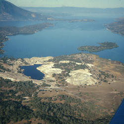
Mining and mineralization of the Clear Lake region
The Geysers-Clear Lake area has been one of the most productive in the United States for mercury, and gold was mined in the late 1800s. Many of the deposits are directly associated with outcrops of early Clear Lake volcanic rocks.

Geology and History of Black Rock Desert Volcanic Field
Black Rock Desert volcanic field is the northernmost volcanic field in a belt of young volcanic fields beginning in the northern Grand Canyon of Arizona and continuing in a north-trending line through Utah. Part of the eastern Basin and Range Province, the Black Rock Desert volcanic field covers nearly 7,000 km2 (2,700 mi) and is 145 km (90 mi) long.