
Looking down from the lookout point at Brink of Lower Falls, over the Yellowstone River, as it flows eastward through the "Grand Canyon of Yellowstone".
Images
Explore our planet through photography and imagery, including climate change and water all the way back to the 1800s when the USGS was surveying the country by horse and buggy.
Filter Total Items: 21558
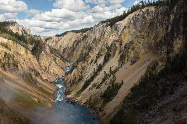
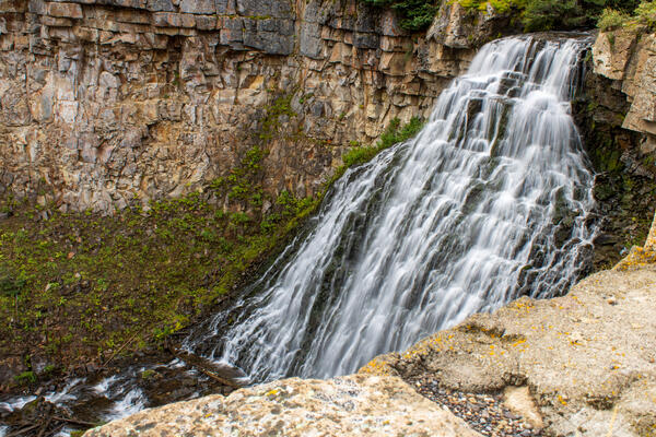
Yellowstone River from Brink of Lower Falls
Looking down from the lookout point at Brink of Lower Falls, over the Yellowstone River, as it flows eastward through the "Grand Canyon of Yellowstone".
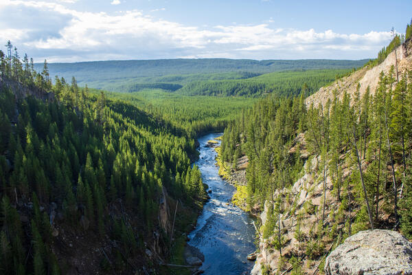
Yellowstone River from Brink of Lower Falls
Looking down from the lookout point at Brink of Lower Falls, over the Yellowstone River, as it flows south into the distance.
Looking down from the lookout point at Brink of Lower Falls, over the Yellowstone River, as it flows south into the distance.
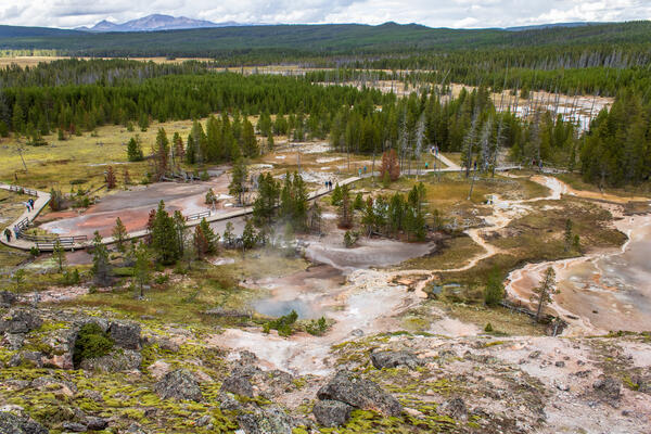
Artists' Painpots
Looking down on the lower portion of Artists' Paintpots in Yellowstone National Park, Wyoming. Artists' Paintpots is a hydrothermal area with many colorful mud pots, hot springs, and geysers.
Looking down on the lower portion of Artists' Paintpots in Yellowstone National Park, Wyoming. Artists' Paintpots is a hydrothermal area with many colorful mud pots, hot springs, and geysers.

Cinnamon Spouter
Cinnamon Spouter is located on the Black Sand Basin Trail in Yellowstone National Park, Wyoming.
Cinnamon Spouter is located on the Black Sand Basin Trail in Yellowstone National Park, Wyoming.

Kepler Cascades
Need time to concentrate or relax? Then listen to the natural sounds of Kepler Cascades in Yellowstone National Park, Wyoming. Kepler Cascades is located just a couple miles away from Old Faithful within Yellowstone National Park, Wyoming.
Need time to concentrate or relax? Then listen to the natural sounds of Kepler Cascades in Yellowstone National Park, Wyoming. Kepler Cascades is located just a couple miles away from Old Faithful within Yellowstone National Park, Wyoming.
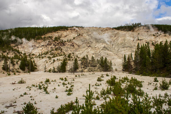
Roaring Mountain
A view of Roaring Mountain in Yellowstone National Park, Wyoming. "Roaring Mountain is a large, acidic thermal area (solfatara) that contains many steam vents (fumaroles). In the late 1800s and early 1900s, the number, size, and power of the fumaroles was much greater than today." (NPS)
A view of Roaring Mountain in Yellowstone National Park, Wyoming. "Roaring Mountain is a large, acidic thermal area (solfatara) that contains many steam vents (fumaroles). In the late 1800s and early 1900s, the number, size, and power of the fumaroles was much greater than today." (NPS)
Rustic Falls
Need time to concentrate or relax? Then listen to the natural sounds of Rustic Falls in Yellowstone National Park, Wyoming. Rustic Falls is a few miles south of Mammoth Hot Springs in Yellowstone National Park, Wyoming.
Need time to concentrate or relax? Then listen to the natural sounds of Rustic Falls in Yellowstone National Park, Wyoming. Rustic Falls is a few miles south of Mammoth Hot Springs in Yellowstone National Park, Wyoming.
June 8, 2023 — Low lava fountaining continues in Halema‘uma‘u crater, Kīlauea volcano
Low fountaining has been active where lava upwells into Halema‘uma‘u crater, at the summit of Kīlauea. This video shows a series of small fountains in the southern portion of the crater floor. Camera shake is due to high winds at the time.
Low fountaining has been active where lava upwells into Halema‘uma‘u crater, at the summit of Kīlauea. This video shows a series of small fountains in the southern portion of the crater floor. Camera shake is due to high winds at the time.

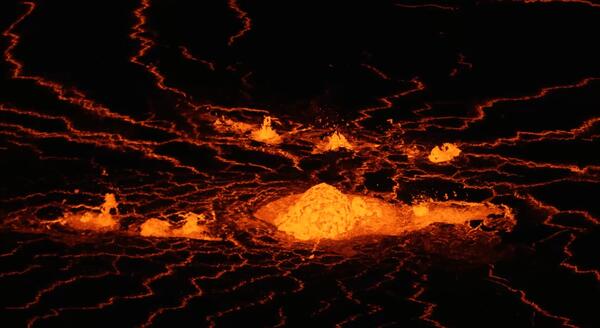
Kīlauea summit eruption in Halema‘uma‘u - June 7, 2023
A summit eruption of Kīlauea volcano, within Halemaʻumaʻu crater, began at approximately 4:44 a.m. on June 7, 2023. Lava is flowing on the crater floor and there are several active vent sources. The eruption at Kīlauea’s summit is occurring within a closed area of Hawai'i Volcanoes National Park and high levels of volcanic gas are the primary hazard of concern.
A summit eruption of Kīlauea volcano, within Halemaʻumaʻu crater, began at approximately 4:44 a.m. on June 7, 2023. Lava is flowing on the crater floor and there are several active vent sources. The eruption at Kīlauea’s summit is occurring within a closed area of Hawai'i Volcanoes National Park and high levels of volcanic gas are the primary hazard of concern.
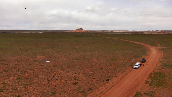
UAS operations near Moab, Utah for carbon sequestration research on public lands
UAS operations near Moab, Utah for carbon sequestration research on public lands
UAS operations near Moab, Utah for carbon sequestration research on public lands
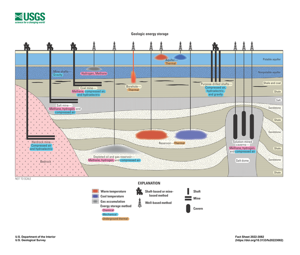
Geologic Energy Storage
Schematic cross section showing examples of chemical, mechanical, and thermal geologic energy storage methods in potential underground settings in a sedimentary basin. This illustration is a higher resolution version of figure 2 of USGS Fact Sheet 2022-3084.
Schematic cross section showing examples of chemical, mechanical, and thermal geologic energy storage methods in potential underground settings in a sedimentary basin. This illustration is a higher resolution version of figure 2 of USGS Fact Sheet 2022-3084.
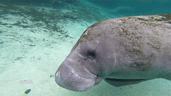
Tummy Rubbing Manatee
An animated GIF of a manatee looking at the camera and rubbing its belly at the same time.
An animated GIF of a manatee looking at the camera and rubbing its belly at the same time.

December 1, 2022 - View of the eruption plume from fissure 3
December 1, 2022 - A view of the eruption plume from fissure 3 on Mauna Loa's Northeast Rift Zone. Geologist for scale on the left. USGS image by J. Schmith.
By
December 1, 2022 - A view of the eruption plume from fissure 3 on Mauna Loa's Northeast Rift Zone. Geologist for scale on the left. USGS image by J. Schmith.
By

Fissure 3 on Mauna Loa's Northeast Rift Zone on Dec. 1, 2022
View of fissure 3 on Mauna Loa's Northeast Rift Zone erupting during the morning of December 1, 2022. Fissure 3 continues to be the dominant of two erupting fissures on Mauna Loa's Northeast Rift Zone.
By
View of fissure 3 on Mauna Loa's Northeast Rift Zone erupting during the morning of December 1, 2022. Fissure 3 continues to be the dominant of two erupting fissures on Mauna Loa's Northeast Rift Zone.
By

Geologists deploy buckets downwind of the erupting fissures to collect samples
December 1, 2022 - USGS Hawaiian Volcano Observatory geologists deploy buckets downwind of the erupting fissures to collect samples. These samples will be analyzed to learn about lava being erupted by Mauna Loa's Northeast Rift Zone.
By
December 1, 2022 - USGS Hawaiian Volcano Observatory geologists deploy buckets downwind of the erupting fissures to collect samples. These samples will be analyzed to learn about lava being erupted by Mauna Loa's Northeast Rift Zone.
By

View of Fissure 3 Erupting on Mauna Loa's Northeast Rift Zone
View of fissure 3 erupting on Mauna Loa's Northeast Rift Zone. View is from approximately 500 meters downrift.
By
View of fissure 3 erupting on Mauna Loa's Northeast Rift Zone. View is from approximately 500 meters downrift.
By
Fissure 3 Mauna Loa - November 30, 2022
This image, taken during an early morning overflight on 30 November 2022, shows Fissure 3, the dominant source of activity. As of 7 a.m. HST, the lava fountains are 20-25 meters in height (65-82 feet) and feed a lava flow moving to the northeast at ~130 meters per hour (0.08 miles per hour).
This image, taken during an early morning overflight on 30 November 2022, shows Fissure 3, the dominant source of activity. As of 7 a.m. HST, the lava fountains are 20-25 meters in height (65-82 feet) and feed a lava flow moving to the northeast at ~130 meters per hour (0.08 miles per hour).

HD Camera Recording Fissure 3 of Mauna Loa (Nov 30, 2022)
Photograph of a high-definition video camera filming fissure 3. Field crews are out today monitoring the eruption of Mauna Loa. Mauna Kea is in the distance behind the fountaining fissure. Taken at about 7:15 AM on November 30, 2022.
Photograph of a high-definition video camera filming fissure 3. Field crews are out today monitoring the eruption of Mauna Loa. Mauna Kea is in the distance behind the fountaining fissure. Taken at about 7:15 AM on November 30, 2022.
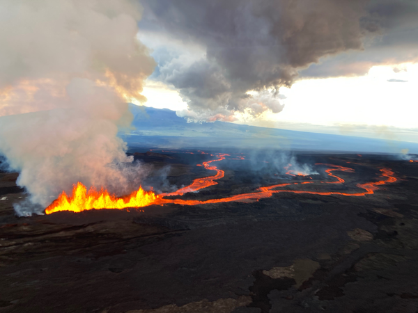
Mauna Loa eruption on November 30, 2022
A field crew was out documenting the location of the front of the flow closest to Saddle Road on Nov. 30, 2022, between 3:00 and 4:00 pm HST. This photo shows the front of the aʻa flow, with a helicopter for scale.
A field crew was out documenting the location of the front of the flow closest to Saddle Road on Nov. 30, 2022, between 3:00 and 4:00 pm HST. This photo shows the front of the aʻa flow, with a helicopter for scale.
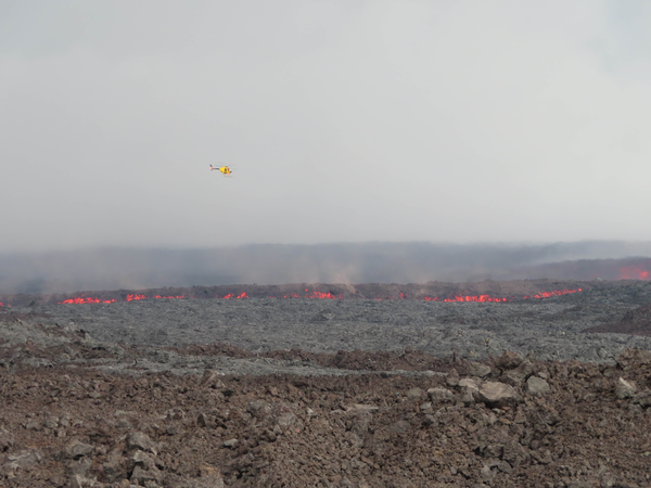
Mauna Loa eruption on November 30, 2022
Photo showing the front of the aʻa flow closest to Saddle Road, taken on Nov. 30, around 3:30 pm HST. The photo was taken looking south to southeastward from the Hilo-Kona Road, approximately 4 miles south of Saddle Road and one mile west of the Mauna Loa Observatory Road.
Photo showing the front of the aʻa flow closest to Saddle Road, taken on Nov. 30, around 3:30 pm HST. The photo was taken looking south to southeastward from the Hilo-Kona Road, approximately 4 miles south of Saddle Road and one mile west of the Mauna Loa Observatory Road.
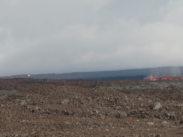