
Yellowstone
Find U.S. Volcano
Current Alerts
Yellowstone
The Yellowstone Plateau volcanic field developed through three volcanic cycles that span two-million years. Two of the eruptions are considered some of the world's largest volcanic events. Yellowstone's youngest eruptions have been lava flows that remain confined to the caldera of present-day Yellowstone National Park. The 77,000 year-old Pitchstone Plateau flow is the volcano's most recent lava.
Quick Facts
Location: Wyoming and Montana
Latitude: 44.615° N
Longitude: 110.6° W
Elevation: 2,805 m / 9,203 f
Volcano type: Caldera
Composition: basalt to rhyolite
Most recent eruption: 70,000 years ago (lava), current hydrothermal explosions
Threat Potential: High*
*based on the National Volcano Early Warning System
Summary
The >2450 km3 (588 mi3) Huckleberry Ridge Tuff erupted about 2.1 million years ago, creating an approximately 75 km (47 mi) wide caldera and thick volcanic deposits. A second eruption cycle concluded with the much smaller Mesa Falls Tuff around 1.3 million years ago. Activity subsequently shifted to the present Yellowstone Plateau and culminated 640,000 years ago with the eruption of the >10003km (240 mi3) Lava Creek Tuff and consequent formation of the 45 x 85 km (28 x 53 mi) caldera. Large volumes of rhyolitic lava flows (approximately 600 km3 (144 mi3) were erupted in the caldera between 180,000 and 70,000 years ago, distributed primarily along two north-south alignments of vents.
No magmatic eruptions have occurred since then, but large hydrothermal explosions have taken place during the Holocene, including from within and near Yellowstone Lake. Uplift and subsidence of the ground surface is centered on two uplifted regions (the Mallard Lake and Sour Creek resurgent domes). Large earthquakes occur just off the plateau along the nearby Teton and Hebgen Lake faults, the latter of which ruptured in 1959 (Ms = 7.5), causing considerable damage to the region. Yellowstone is presently the site of one of the world's largest hydrothermal systems including Earth's largest concentration of geysers.
News
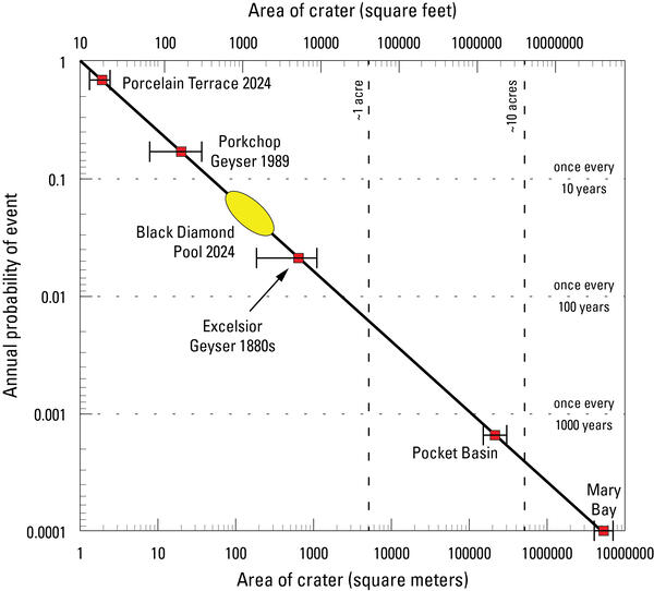
The probability of hydrothermal explosions in Yellowstone
The July 23, 2024, hydrothermal explosion at Biscuit Basin
A small hydrothermal explosion at Norris Geyser Basin
Publications
2018 update to the U.S. Geological Survey national volcanic threat assessment
When erupting, all volcanoes pose a degree of risk to people and infrastructure, however, the risks are not equivalent from one volcano to another because of differences in eruptive style and geographic location. Assessing the relative threats posed by U.S. volcanoes identifies which volcanoes warrant the greatest risk-mitigation efforts by the U.S. Geological Survey and its partners. This update


")

")


")
