
Tarrabool Lake is a seasonal lake in Australia’s Northern Territory. While the lake’s water level fluctuates from year to year, its swampy wetlands and the surrounding tropical forested areas supports an essential habitat for small mammals, reptiles, and a wide variety of bird species.
Multimedia
Images

Tarrabool Lake, Northern Territory
Tarrabool Lake is a seasonal lake in Australia’s Northern Territory. While the lake’s water level fluctuates from year to year, its swampy wetlands and the surrounding tropical forested areas supports an essential habitat for small mammals, reptiles, and a wide variety of bird species.

Landsat Images of the Park Fire, July 2024
The Park Fire north of Sacramento in California forced thousands of residents to evacuate in late July as it spread to over 370,000 acres. The fire started on July 24th. Landsat 8 captured an image of the fire two days later.
The Park Fire north of Sacramento in California forced thousands of residents to evacuate in late July as it spread to over 370,000 acres. The fire started on July 24th. Landsat 8 captured an image of the fire two days later.

Landsat Reveals Cape Cod's Changing Coastlines
Ocean currents, and the sediments they transport, have constantly shifted the Cape Cod barrier islands over time. Some of the abrupt changes, however, can be linked directly to a storm.
Ocean currents, and the sediments they transport, have constantly shifted the Cape Cod barrier islands over time. Some of the abrupt changes, however, can be linked directly to a storm.

Australia has formally joined the United States-led Landsat Next satellite program
Minister for Foreign Affairs, Penny Wong, and U.S. Secretary of State, Antony Blinken, with the signed bilateral statement on the Landsat Next program.
Minister for Foreign Affairs, Penny Wong, and U.S. Secretary of State, Antony Blinken, with the signed bilateral statement on the Landsat Next program.

USGS and Australia formally partner for upcoming Landsat Next satellite mission
Alison Rose, Chief of Space Division, Geoscience Australia, and Darcee Killpack, acting Associate Director, Core Science Systems, United States Geological Survey, signing the Memorandum of Understanding formally operationalizing the Landsat Next partnership.
Alison Rose, Chief of Space Division, Geoscience Australia, and Darcee Killpack, acting Associate Director, Core Science Systems, United States Geological Survey, signing the Memorandum of Understanding formally operationalizing the Landsat Next partnership.

Australia has formally joined the Landsat Next satellite program
Minister for Foreign Affairs, Penny Wong, and U.S. Secretary of State, Antony Blinken, with the signed bilateral statement on the Landsat Next program.
Minister for Foreign Affairs, Penny Wong, and U.S. Secretary of State, Antony Blinken, with the signed bilateral statement on the Landsat Next program.
Videos
")
Landsat Captures Mexico's Trending Drought (Image of the Week)
Prolonged drought has lowered water levels in Laguna Bustillos in Chihuahua State, Mexico, killing thousands of fish.
Prolonged drought has lowered water levels in Laguna Bustillos in Chihuahua State, Mexico, killing thousands of fish.

The Evolution of UAS Platforms at USGS
The Department of the Interior (DOI) and U.S. Geological Survey (USGS) took an interest in uncrewed aircraft system (UAS) technologies in the early 2000s, when UAS were predominantly being used for military applications.
The Department of the Interior (DOI) and U.S. Geological Survey (USGS) took an interest in uncrewed aircraft system (UAS) technologies in the early 2000s, when UAS were predominantly being used for military applications.
")
Record Wildfire in Texas (Image of the Week)
The Smokehouse Creek Fire started about 1 mile north of Stinnett, Texas on February 26th, 2024. Three days later, the fire had consumed over 1 million acres. With a total area of 1,654 square miles, it became the largest fire on record in Texas. That's larger than New York's Long Island.
The Smokehouse Creek Fire started about 1 mile north of Stinnett, Texas on February 26th, 2024. Three days later, the fire had consumed over 1 million acres. With a total area of 1,654 square miles, it became the largest fire on record in Texas. That's larger than New York's Long Island.

UAS Operations for Carbon Sequestration Research on Public Lands near Moab, Utah in May 2023
In support of U.S. Geological Survey (USGS) Southwest Biological Science Center research, the USGS National Uncrewed Systems Office (NUSO) conducted uncrewed aircraft systems (UAS) remote sensing flights near Moab, Utah in May 2023 for multi-scale carbon sequestration research on public lands.
In support of U.S. Geological Survey (USGS) Southwest Biological Science Center research, the USGS National Uncrewed Systems Office (NUSO) conducted uncrewed aircraft systems (UAS) remote sensing flights near Moab, Utah in May 2023 for multi-scale carbon sequestration research on public lands.

Perry Victory and International Peace Memorial Taken by Drone
The NUSO and the National Park Service (NPS) Heritage Document Programs partnered in May 2024 to perform a UAS-based 3D scan of Perry’s Victory and International Peace Memorial.
The NUSO and the National Park Service (NPS) Heritage Document Programs partnered in May 2024 to perform a UAS-based 3D scan of Perry’s Victory and International Peace Memorial.

Image of the Week: A Warm February in Northern Minnesota
Like many lakes in northern Minnesota, Mille Lacs near Brainerd experienced an uncommonly warm winter this year, with lower than average snowfall. Natural color Landsat images from the past ten Februarys reveal a stark change in 2024.
Like many lakes in northern Minnesota, Mille Lacs near Brainerd experienced an uncommonly warm winter this year, with lower than average snowfall. Natural color Landsat images from the past ten Februarys reveal a stark change in 2024.
Audio
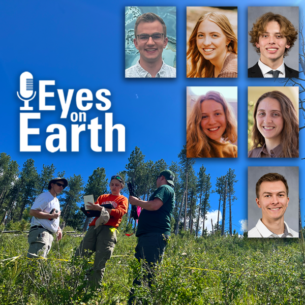
Eyes on Earth Episode 122 – EROS Interns, 2024
In this episode of Eyes on Earth, we talked with some of the interns who worked at EROS this summer. They shared their experiences learning about the cloud, AI, wildland fire research, terrestrial lidar scanning, and more. The common theme among them was recognizing the value of the EROS mission and noticing the passion their co-workers demonstrated in their work.
In this episode of Eyes on Earth, we talked with some of the interns who worked at EROS this summer. They shared their experiences learning about the cloud, AI, wildland fire research, terrestrial lidar scanning, and more. The common theme among them was recognizing the value of the EROS mission and noticing the passion their co-workers demonstrated in their work.

Eyes on Earth Episode 121 – Mapping the Australia Coastline
This episode of Eyes on Earth is the second in a series about how Landsat is helping researchers study coastal changes. The first one was about mapping changes to beaches in California and using Landsat to create models to predict how the coastline may change in the future because of sea level rise and coastal erosion.
This episode of Eyes on Earth is the second in a series about how Landsat is helping researchers study coastal changes. The first one was about mapping changes to beaches in California and using Landsat to create models to predict how the coastline may change in the future because of sea level rise and coastal erosion.

Eyes on Earth Episode 120 – Mapping the California Coastline
In this episode of Eyes on Earth, we begin a series on Landsat’s usefulness in coastal studies. First, we talk with Sean Vitousek, a USGS research oceanographer, about changes to beaches in California and how he is using Landsat and other data to create models that can predict how the coastline may change in the future because of sea level rise and coastal erosion.
In this episode of Eyes on Earth, we begin a series on Landsat’s usefulness in coastal studies. First, we talk with Sean Vitousek, a USGS research oceanographer, about changes to beaches in California and how he is using Landsat and other data to create models that can predict how the coastline may change in the future because of sea level rise and coastal erosion.

Eyes on Earth Episode 119 – Kristi Kline: EROS Career Reflections
In this episode of Eyes on Earth, we talk with Kristi Kline about the constant changes and innovations that have been needed at EROS to keep up with changes in computer tech and data processing. Kline has been a part of helping to implement these changes over the past 27 years and is now retiring at the end of May 2024.
In this episode of Eyes on Earth, we talk with Kristi Kline about the constant changes and innovations that have been needed at EROS to keep up with changes in computer tech and data processing. Kline has been a part of helping to implement these changes over the past 27 years and is now retiring at the end of May 2024.
Eyes on Earth Episode 118 – Preparing for Landsat Next, Part 2
In this episode of Eyes on Earth, we talk with several people involved with the next Landsat mission, targeted for launch around 2030. While that may seem like a ways into the future, it takes a lot of work to prepare for such a big mission.
In this episode of Eyes on Earth, we talk with several people involved with the next Landsat mission, targeted for launch around 2030. While that may seem like a ways into the future, it takes a lot of work to prepare for such a big mission.

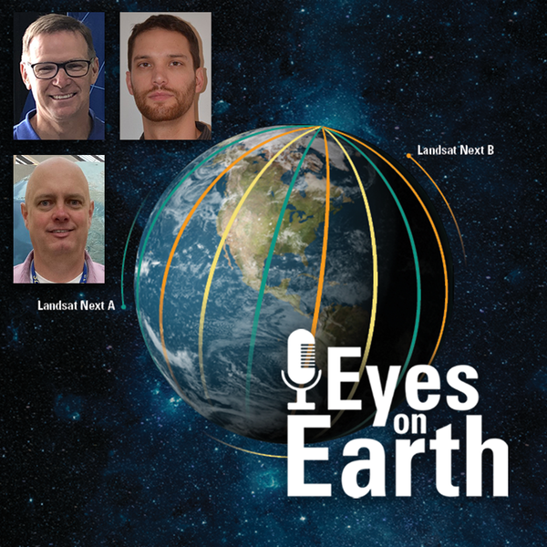
Eyes on Earth Episode 117 – Preparing for Landsat Next, Part 1
In this episode of Eyes on Earth, we talk with several people involved with the next Landsat mission. In Part 1, we’ll hear about how different Landsat Next will be from previous Landsat missions and how its additional spectral bands, higher resolution and 6-day revisit will benefit science and society.
In this episode of Eyes on Earth, we talk with several people involved with the next Landsat mission. In Part 1, we’ll hear about how different Landsat Next will be from previous Landsat missions and how its additional spectral bands, higher resolution and 6-day revisit will benefit science and society.