
Earth Observing Satellites Online Compendium
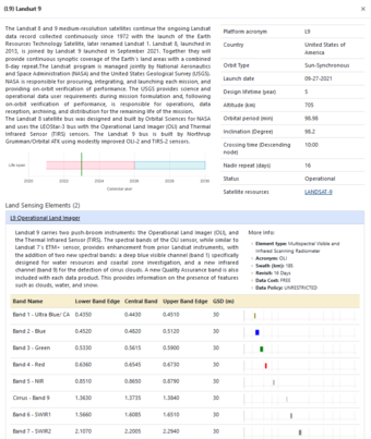
The Joint Agency Commercial Imagery Evaluation (JACIE) Earth Observing Satellites Online Compendium contains details about past, present and future Earth observing satellites and the sensors they carry.
Derived from print versions of Compendiums published in 2019, 2020, and 2022, this resource has been developed and is managed by the Requirements, Capabilities and Analysis for Earth Observation (RCA-EO) team at the USGS Earth Resources Observation and Science (EROS) Center in Sioux Falls, South Dakota.
Visit the Using the Earth Observing Satellites Online Compendium webpage to learn how to best search the tool.
The content of the Compendium is updated weekly. The overall application was last updated February 2024.
Please use this suggested citation when referencing the Compendium:
Clauson, J, Cantrell, S., Vrabel, J., Oeding, J., Ranjitkar, B., Rusten, T., Ramaseri, S., and Casey, K., 2024, Earth Observing Sensing Satellites Online Compendium: U.S. Geological Survey digital data, https://calval.cr.usgs.gov/apps/compendium.
The images below display the countries that have owned and/or operated Earth observing satellites, and the number of satellites launched each year. The data represented in these images are gathered from various sources and are updated regularly by the USGS ECCOE team.

