
Oregon Water Science Center
Welcome to the USGS in Oregon. Our mission is to explore the natural world around us and provide reliable scientific information to help Federal, State, and local agencies, Tribes, and the public make well-informed decisions. Our research is widely used to manage Oregon's water resources for the benefit and safety of people and the environment.
Live Stream Conditions
Live Stream Conditions
See what is happening in streams near you. View real-time stream data for streams around Oregon.
New or Relevant Information
New or Relevant Information
See what the USGS is doing locally.
News
Low-flow periods and trends across the United States
Low-flow periods and trends across the United States
Surface-water extent in the Klamath Marsh
Surface-water extent in the Klamath Marsh
Mapping river channels and floodplains important to spring Chinook Salmon
Mapping river channels and floodplains important to spring Chinook Salmon
Publications
Low-flow period seasonality, trends, and climate linkages across the United States
Low-flow period properties, including timing, magnitude, and duration, influence many key processes for water resource managers and ecosystems. We computed annual low-flow period duration and timing metrics from 1951 to 2020 for 1032 conterminous United States (CONUS) streamgages and analyzed spatial patterns, trends through time, and relationships to climate. Results show northwestern and eastern
Assessment of long-term changes in surface-water extent within Klamath Marsh, south-central Oregon, 1985–2021
The annual maximum extent of surface water in Klamath Marsh has naturally fluctuated in response to periods of wet and dry conditions in the surrounding basin. Field observations during the 2010s indicate that the annual maximum extent of surface water has been declining and the marsh is not responding to hydrologic inputs as it had historically. This report describes the results of a hydrologic e
Integrating depth measurements from gaging stations with image archives for spectrally based remote sensing of river bathymetry
Remote sensing can be an effective tool for mapping river bathymetry, but the need for direct measurements to calibrate image-derived depth estimates impedes broader application of this approach. One way to circumvent the need for field campaigns dedicated to calibration is to capitalize upon existing data. In this study, we introduce a framework for Bathymetric Mapping using Gage Records and Imag
Science
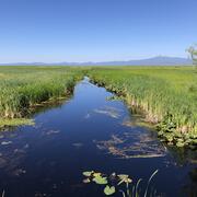
Surface-water extent in the Klamath Marsh
Satellite imagery and the interplay of climate and hydrologic data tell the story of surface-water decline in the Klamath Marsh.
Integrated Water Science Basins: Willamette River
The Willamette River Basin reflects the conflicting water demands between humans and ecosystems—particularly salmon— and the challenge resource managers face throughout the Pacific Northwest.

Upper Klamath Basin Studies and Data Collection
The USGS has been studying the Klamath Basin for decades. The USGS provides unbiased data to Tribal partners and resource managers to aid with complex management and conservation efforts.