
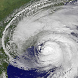
Hurricane Debby Brings Rainfall to Georgia and Coastal Carolinas
Links to South Atlantic Rainfall Maps and U.S. Drought Map
Links to South Atlantic Rainfall Maps and U.S. Drought Map
South Atlantic Water Science Center (SAWSC)
Welcome to USGS South Atlantic Water Science Center's (SAWSC) Website. We offer water information for Georgia, North Carolina, and South Carolina.
Hydrologic Data at SAWSC
Hydrologic Data at SAWSC
We provide current and historical surface-water, groundwater, water quality, water use, and ecological data in various formats (map, graphical, tabular).
Science at SAWSC
Science at SAWSC
The South Atlantic Water Science Center collects high-quality hydrologic data and conducts unbiased, scientifically sound research on Georgia's, North Carolina's, and South Carolina's water resources.
News
U.S. Geological Survey responds to Tropical Storm Debby in South Carolina
U.S. Geological Survey responds to Tropical Storm Debby in South Carolina
Hurricane Debby Makes Landfall, South Atlantic Water Science Center Installs Rapid Deployment Gages (RDG)
Hurricane Debby Makes Landfall, South Atlantic Water Science Center Installs Rapid Deployment Gages (RDG)
Event: Explore USGS Careers in the Southeast 2024
Event: Explore USGS Careers in the Southeast 2024
Publications
Triangle Area Water Supply Monitoring Project, North Carolina
IntroductionRivers and surface-water reservoirs supply drinking water to most residents throughout the Triangle area in North Carolina. These drinking-water supplies may be at risk because of rapid and continued land use change throughout the region. In partnership with the U.S. Geological Survey, several Triangle-area municipalities established a long-term water-quality and streamflow monitoring
Assessment of nutrient load estimation approaches for small urban streams in Durham, North Carolina
This cooperative study between the City of Durham Public Works Department, Stormwater Division and U.S. Geological Survey evaluated whether alternate monitoring strategies that incorporated samples collected across an increased range of streamflows would improve nutrient load estimates for Ellerbe and Sandy Creeks, two small, highly urbanized streams in the City of Durham, North Carolina. Water-qu
Detection of periodic peaks in Karenia brevis concentration consistent with the time-delay logistic equation
The logistic equation models single-species population growth with a sigmoid curve that begins as exponential and ends with an asymptotic approach to a final population determined by natural system carrying capacity. But the population of a natural system often does not stabilize as it approaches carrying capacity. Instead, it exhibits periodic change, sometimes with very large amplitudes. The tim
Science

Manning's Roughness Coefficients for South Carolina Streams
The objective of this project will be to verify channel and flood plain Manning’s roughness coefficients (n) for selected streams in South Carolina. For streams with cross sections that warrant subdivision of the n values, the verification for the channel and flood plain will be performed by subdividing the n values instead of using a composite n value. The n values will be determined for various...
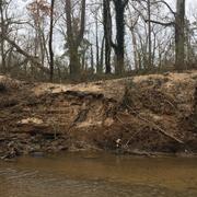
Raleigh Bank Erosion Project
The City of Raleigh partnered with the U.S. Geological Survey (USGS) to assist in assessing streambank erosion hotspots along the City of Raleigh’s stream network to support the City’s efforts of prioritizing future stream mitigation projects. Streambank erosion potential will be assessed using remotely sensed light detection and ranging (lidar) data, field assessments of streambank conditions...
Hurricane Monitoring Information for Georgia, North Carolina, and South Carolina
Hurricane Information for Georgia, North Carolina, and South Carolina.