
Current Research
Idaho's Water Quality
https://www.usgs.gov/centers/idaho-water-science-center/science/water-quality
https://www.usgs.gov/centers/idaho-water-science-center/science/water-quality
Idaho National Laboratory Project Office
Idaho Water Science Center
Water is critical to Idaho's quality of life and economic vitality. We provide reliable, unbiased hydrologic data and scientific studies to help our local, state, tribal, and federal partners effectively manage Idaho's water resources.
Idaho Water Dashboard
Idaho Water Dashboard
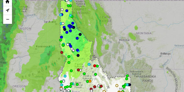
Explore real-time streamflow, groundwater, water-quality, and weather conditions and access data via our interactive map.
News
Wildfires are increasing concentrations of mercury in Pacific Northwest headwater streams
Wildfires are increasing concentrations of mercury in Pacific Northwest headwater streams
Idaho Hydrologic Update, July 2024
Idaho Hydrologic Update, July 2024
Idaho Hydrologic Update, May 2024
Idaho Hydrologic Update, May 2024
Publications
Wildfires influence mercury transport, methylation, and bioaccumulation in headwater streams of the Pacific Northwest
The increasing frequency and severity of wildfires are among the most visible impacts of climate change. However, the effects of wildfires on mercury (Hg) transformations and bioaccumulation in stream ecosystems are poorly understood. We sampled soils, water, sediment, in-stream leaf litter, periphyton, and aquatic invertebrates in 36 burned (one-year post fire) and 21 reference headwater streams
Potential hazards of polycyclic aromatic hydrocarbons in Great Lakes tributaries using water column and porewater passive samplers and sediment wquilibrium partitioning
The potential for polycyclic aromatic hydrocarbon (PAH)-related effects in benthic organisms is commonly estimated from organic carbon-normalized sediment concentrations based on equilibrium partitioning (EqP). Although this approach is useful for screening purposes, it may overestimate PAH bioavailability by orders of magnitude in some sediments, leading to inflated exposure estimates and potenti
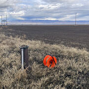
An update of hydrologic conditions and distribution of selected constituents in water, eastern Snake River aquifer and perched groundwater zones, Idaho National Laboratory, Idaho, emphasis 2019–21
Since 1952, wastewater discharged to infiltration ponds (also called “percolation ponds”) and disposal wells at the Idaho National Laboratory (INL) has affected water quality in the eastern Snake River Plain (ESRP) aquifer and perched groundwater zones underlying the INL. The U.S. Geological Survey (USGS), in cooperation with the U.S. Department of Energy (DOE), maintains groundwater-monitoring ne
Science
Characterizing the Water Resources of the Mountain Home Plateau, Southern Idaho
Residents, businesses, agricultural producers, and Mountain Home Air Force Base all rely on the Mountain Home Plateau's groundwater resources. Declining groundwater levels raise concerns about the sustainability of the regional aquifer. The Idaho Department of Water Resources (IDWR) needs updated information about the groundwater resources of the Mountain Home Plateau to help administer water...
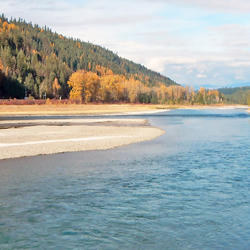
Monitoring Mining Effects in the Kootenai River Watershed
The Kootenai River (Kootenay in Canada) rises from the Canadian Rockies and flows south in an arc through Montana and Idaho before swinging back into British Columbia and the Columbia River. The uplifted sedimentary rocks forming the southern Canadian Rockies have rich coal deposits that have been mined for many decades. The coal beds and associated rock layers are enriched with other minerals as...

Evaluating Spatial and Temporal Fine-Scale Movement of Kootenai River White Sturgeon
The U.S. Fish and Wildlife Service has published a plan for recovering the endangered Kootenai River white sturgeon. This study supports the objectives of that plan by quantifying white sturgeon habitat preference within a recently restored reach of the Kootenai River. Fine-scale acoustic telemetry positioning data will be integrated with quasi-three-dimensional hydraulic model simulations for the...