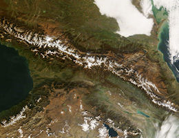
Caucasian Geography
 All Caucasia, which embraces not only the Great Mountains of Caucasus proper but also the country to the north and to the south of the Great Caucasian Range, is designated by the common term "Caucasus". This is a Latinized form of the ancient Greek name for this region "Kaukasos". The Greek term may in turn be traced back to Old Iranian "kap kah" which means "Big Mountain". The ancient nomenclature reflects the historical importance of the area where Europe and Asia converge. Ancient Greeks made the Great Mountain Range the scene of the mythical sufferings of Prometheus, and the Argonauts sought the Golden Fleece in the mysterious land of Colchis on the Black Sea coast, south of the Range. Thus, geographically, the term "Caucasus" represents a definite territory located between the Black and Caspian Seas, a wide isthmus separating these seas and divided by the Great Caucasus Mountain Range into two parts — North Caucasus and South Caucasus.
 East of Kazbek the range narrows and is narrowest south of Vladikarkaz, where it is crossed by the Russian military road to Georgia. This road runs over the Kobi Pass and through the great Davial gorge, one of the greatest mountain chasms in the world. The eastern part of the Caucasus, from Kazbek to the Caspian, is of much more complicated structure; the range widening and including a high plateau crossed by subordinate ranges having an east-northeast and west-southwest direction, though what may be termed the main axis continues its southeast course.
The plains of Caucasia north of the mountains are underlaid by Tertiary and Quaternary strata. The foot hills of the western Caucasus and the plateau of the eastern Caucasus show rocks of Cretaceous and Jurassic age, and nearer the main axis of the range are Palaeozoic formations. The main axis shows schists and gneisses with granite and syenite. Trachyte and similar rocks occur, and some of the peaks, Kazbek, are probably in part of volcanic origin.
The scenery of the Caucasus is wild and gloomy rather than beautiful. The lower slopes are thickly wooded, but there is not the combination of dark forests, beautiful lakes and graceful snow-crowned summits that makes some ranges — for instance the Selkirks in British Columbia — so attractive to the mountain climber.
This varied and rugged range of mountains is covered in many parts with forests of the most luxuriant vegetation, though, as we have said, its wild, sharp peaks pierce beyond the line of perpetual snow: it extends from the Black Sea to the Caspian, and forms nature's boundary between the two continents of Europe and Asia; and on this range, with its numerous branches, offsets and headlands, the name of the Caucasus has been bestowed.
Tradition has chained Prometheus to the highest point of the Caucasus, and laid the scene of the Golden Fleece expedition on the lovely slopes that overhang the Black Sea. The ark of Noah, too, is said to have rested on a peak of one of its branches, but beyond this, both history and tradition are nearly silent concerning this mountain land; and there are, even at this hour, extensive tracts of country untrodden by European foot, and known to us only by the vague and uncertain glimpses afforded by hearsay or imagination.
|
NEWSLETTER
|
| Join the GlobalSecurity.org mailing list |
|
|
|

