
Portal:World
The World Portal


The world is the totality of entities, the whole of reality, or everything that exists. The nature of the world has been conceptualized differently in different fields. Some conceptions see the world as unique while others talk of a "plurality of worlds". Some treat the world as one simple object while others analyze the world as a complex made up of parts.
In scientific cosmology, the world or universe is commonly defined as "[t]he totality of all space and time; all that is, has been, and will be". Theories of modality talk of possible worlds as complete and consistent ways how things could have been. Phenomenology, starting from the horizon of co-given objects present in the periphery of every experience, defines the world as the biggest horizon or the "horizon of all horizons". In philosophy of mind, the world is contrasted with the mind as that which is represented by the mind.
Theology conceptualizes the world in relation to God, for example, as God's creation, as identical to God or as the two being interdependent. In religions, there is a tendency to downgrade the material or sensory world in favor of a spiritual world to be sought through religious practice. A comprehensive representation of the world and our place in it, as is found in religions, is known as a worldview. Cosmogony is the field that studies the origin or creation of the world while eschatology refers to the science or doctrine of the last things or of the end of the world.
In various contexts, the term "world" takes a more restricted meaning associated, for example, with the Earth and all life on it, with humanity as a whole or with an international or intercontinental scope. In this sense, world history refers to the history of humanity as a whole and world politics is the discipline of political science studying issues that transcend nations and continents. Other examples include terms such as "world religion", "world language", "world government", "world war", "world population", "world economy", or "world championship". (Full article...)
Selected articles -
-

The Space Age is a period encompassing the activities related to the space race, space exploration, space technology, and the cultural developments influenced by these events, beginning with the launch of Sputnik 1 on October 4, 1957, and continuing to the present.
This period is characterized by changes in emphasis on particular areas of space exploration and applications. Initially, the United States and the Soviet Union invested unprecedented amounts of resources in breaking records and being first to meet milestones in crewed and uncrewed exploration. The United States established the National Aeronautics and Space Administration (NASA) and the USSR established the Kosmicheskaya programma SSSR to meet these goals. This period of competition gave way to cooperation between those nations and emphasis on scientific research and commercial applications of space-based technology. (Full article...) -
Economic globalization is one of the three main dimensions of globalization commonly found in academic literature, with the two others being political globalization and cultural globalization, as well as the general term of globalization.
Economic globalization refers to the widespread international movement of goods, capital, services, technology and information. It is the increasing economic integration and interdependence of national, regional, and local economies across the world through an intensification of cross-border movement of goods, services, technologies and capital. Economic globalization primarily comprises the globalization of production, finance, markets, technology, organizational regimes, institutions, corporations, and people.
While economic globalization has been expanding since the emergence of trans-national trade, it has grown at an increased rate due to improvements in the efficiency of long-distance transportation, advances in telecommunication, the importance of information rather than physical capital in the modern economy, and by developments in science and technology. The rate of globalization has also increased under the framework of the General Agreement on Tariffs and Trade and the World Trade Organization, in which countries gradually cut down trade barriers and opened up their current accounts and capital accounts. This recent boom has been largely supported by developed economies integrating with developing countries through foreign direct investment, lowering costs of doing business, the reduction of trade barriers, and in many cases cross-border migration. (Full article...) -

The International Telecommunication Union (ITU) is a specialized agency of the United Nations responsible for many matters related to information and communication technologies. It was established on 17 May 1865 as the International Telegraph Union, significantly predating the UN and making it the oldest UN agency. Doreen Bogdan-Martin is the Secretary-General of ITU, the first woman to serve as its head.
The ITU was initially aimed at helping connect telegraphic networks between countries, with its mandate consistently broadening with the advent of new communications technologies; it adopted its current name in 1932 to reflect its expanded responsibilities over radio and the telephone. On 15 November 1947, the ITU entered into an agreement with the newly created United Nations to become a specialized agency within the UN system, which formally entered into force on 1 January 1949. (Full article...) -
Effects of climate change are well documented and growing for Earth's natural environment and human societies. Changes to the climate system include an overall warming trend, changes to precipitation patterns, and more extreme weather. As the climate changes it impacts the natural environment with effects such as more intense forest fires, thawing permafrost, and desertification. These changes impact ecosystems and societies, and can become irreversible once tipping points are crossed. Climate activists are engaged in a range of activities around the world that seek to ameloriate these issues or prevent them from happening.
The effects of climate change vary in timing and location. Up until now the Arctic has warmed faster than most other regions due to climate change feedbacks. Surface air temperatures over land have also increased at about twice the rate they do over the ocean, causing intense heat waves. These temperatures would stabilize if greenhouse gas emissions were brought under control. Ice sheets and oceans absorb the vast majority of excess heat in the atmosphere, delaying effects there but causing them to accelerate and then continue after surface temperatures stabilize. Sea level rise is a particular long term concern as a result. The effects of ocean warming also include marine heatwaves, ocean stratification, deoxygenation, and changes to ocean currents. The ocean is also acidifying as it absorbs carbon dioxide from the atmosphere. (Full article...) -

The astronomical symbol of Earth represents either the four quadrants of the world or the four continents.
Several cosmological and mythological systems portray four corners of the world or four quarters of the world corresponding approximately to the four points of the compass (or the two solstices and two equinoxes). At the center may lie a sacred mountain, garden, world tree, or other beginning-point of creation. Often four rivers run to the four corners of the world, and water or irrigate the four quadrants of Earth. (Full article...) -
This article lists the world's busiest container ports (ports with container terminals that specialize in handling goods transported in intermodal shipping containers), by total number of twenty-foot equivalent units (TEUs) transported through the port. The table lists volume in thousands of TEU per year. The vast majority of containers moved by large, ocean-faring container ships are 20-foot (1 TEU) and 40-foot (2 TEU) ISO-standard shipping containers, with 40-foot units outnumbering 20-foot units to such an extent that the actual number of containers moved is between 55%–60% of the number of TEUs counted. (Full article...)
-
The United Nations uses three definitions for what constitutes a city, as not all cities in all jurisdictions are classified using the same criteria. Cities may be defined as the cities proper, the extent of their urban area, or their metropolitan regions. (Full article...)


General images -
-
 Artist's impression of Earth during the later Archean, the largely cooled planetary crust and water-rich barren surface, marked by volcanoes and continents, features already round microbialites. The Moon, still orbiting Earth much closer than today and still dominating Earth's sky, produced strong tides. (from History of Earth)
 -
 Chloroplasts in the cells of a moss (from History of Earth)
 -
 Artist's rendition of an oxinated fully-frozen Snowball Earth with no remaining liquid surface water. (from History of Earth)
 -
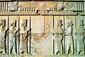 Persepolis, Achaemenid Empire, 6th century BCE
 -
 A reconstruction of Pannotia (550 Ma). (from History of Earth)
 -
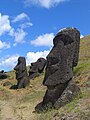
 Machu Picchu, Inca Empire, Peru
 -
 An artist's rendering of a protoplanetary disk (from History of Earth)
 -
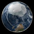 A composite image of Earth, with its different types of surface discernible: Earth's surface dominating Ocean (blue), Africa with lush (green) to dry (brown) land and Earth's polar ice in the form of Antarctic sea ice (grey) covering the Antarctic or Southern Ocean and the Antarctic ice sheet (white) covering Antarctica. (from Earth)
 -
 Fall of the Berlin Wall, 1989
 -
 Satellite time lapse imagery of Earth's rotation showing axis tilt (from Earth)
 -

-

-
 Chennakesava Temple, Belur, India
 -

-
 Empires of the world in 1898
 -
 Earth's history with time-spans of the eons to scale. Mameans "million years ago". (from History of Earth)
 -
-
 COVID-19 pandemic, 2020 (from Human history)
 -
 Great Mosque of Kairouan, Tunisia, founded 670 CE
 -
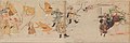 Battle during the 1281 Mongol invasion of Japan
 -
 The replicator in virtually all known life is deoxyribonucleic acid. DNA is far more complex than the original replicator and its replication systems are highly elaborate. (from History of Earth)
 -
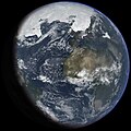
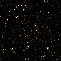 Image of the physical world, captured by the Hubble Space Telescope (from World)
 -
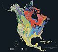 Geologic map of North America, color-coded by age. From most recent to oldest, age is indicated by yellow, green, blue, and red. The reds and pinks indicate rock from the Archean.
 -
 Olmec colossal head, now at the Museo de Antropología de Xalapa
 -
 A composite image of artificial light emissions at night on a map of Earth (from Earth)
 -
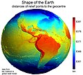 Earth's western hemisphere showing topography relative to Earth's center instead of to mean sea level, as in common topographic maps (from Earth)
 -
 Graph showing range of estimated partial pressure of atmospheric oxygen through geologic time (from History of Earth)
 -
 Tiktaalik, a fish with limb-like fins and a predecessor of tetrapods. Reconstruction from fossils about 375 million years old. (from History of Earth)
 -
 Ming dynasty section, Great Wall of China
 -
 Tracy Caldwell Dyson, a NASA astronaut, observing Earth from the Cupola module at the International Space Station on 11 September 2010 (from Earth)
 -
 "Lucy", the first Australopithecus afarensis skeleton found, was only 1.06 m (3 ft 6 in) tall.
 -
-

-
 Benin Bronze head from Nigeria
 -

-
 Ajloun Castle, Jordan
 -
 First airplane, the Wright Flyer, flew on 17 December 1903.
 -
 A pillar at Göbekli Tepe
 -
 Angkor Wat temple complex, Cambodia, early 12th century
 -
 Dinosaurs were the dominant terrestrial vertebrates throughout most of the Mesozoic (from History of Earth)
 -

-

-

-
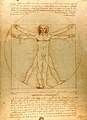 Vitruvian Man by Leonardo da Vinci epitomizes the advances in art and science seen during the Renaissance. (from History of Earth)
 -
 A reconstruction of human history based on fossil data. (from History of Earth)
 -

-
 A computer-generated image mapping the prevalence of artificial satellites and space debris around Earth in geosynchronous and low Earth orbit (from Earth)
 -
 Standing Buddha from Gandhara, 2nd century CE
 -
-
 Lithified stromatolites on the shores of Lake Thetis, Western Australia. Archean stromatolites are the first direct fossil traces of life on Earth. (from History of Earth)
 -
 A banded iron formation from the 3.15 Ga Moodies Group, Barberton Greenstone Belt, South Africa. Red layers represent the times when oxygen was available; gray layers were formed in anoxic circumstances. (from History of Earth)
 -
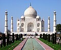 Taj Mahal, Mughal Empire, India
 -
 Shanghai. China urbanized rapidly in the 21st century.
 -
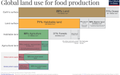 Earth's land use for human agriculture in 2019 (from Earth)
 -
 Great Pyramids of Giza, Egypt
 -
-
 Yggdrasil, an attempt to reconstruct the Norse world tree which connects the heavens, the world, and the underworld. (from World)
 -
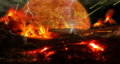 Artist's impression of a Hadean landscape with the relatively newly formed Moon still looming closely over Earth and both bodies sustaining strong volcanism. (from History of Earth)
 -
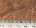 A 580 million year old fossil of Spriggina floundensi, an animal from the Ediacaran period. Such life forms could have been ancestors to the many new forms that originated in the Cambrian Explosion. (from History of Earth)
 -
 Cross-section through a liposome (from History of Earth)
 -
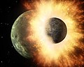 Artist's impression of the enormous collision that probably formed the Moon (from History of Earth)
 -
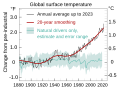 Change in average surface air temperature and drivers for that change. Human activity has caused increased temperatures, with natural forces adding some variability. (from Earth)
 -

-
 A 2012 artistic impression of the early Solar System's protoplanetary disk from which Earth and other Solar System bodies were formed (from Earth)
 -
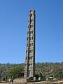 Obelisk of Axum, Ethiopia
 -
 A schematic view of Earth's magnetosphere with solar wind flowing from left to right (from Earth)
 -
 A view of Earth with its global ocean and cloud cover, which dominate Earth's surface and hydrosphere; at Earth's polar regions, its hydrosphere forms larger areas of ice cover. (from Earth)
 -
 Florence, birthplace of the Italian Renaissance
 -
 A map of heat flow from Earth's interior to the surface of Earth's crust, mostly along the oceanic ridges (from Earth)
 -

-
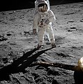
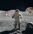 Last Moon landing: Apollo 17 (1972)
 -
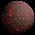 Artist's conception of Hadean Eon Earth, when it was much hotter and inhospitable to all forms of life. (from History of Earth)
 -
 A view of Earth with different layers of its atmosphere visible: the troposphere with its clouds casting shadows, a band of stratospheric blue sky at the horizon, and a line of green airglow of the lower thermosphere around an altitude of 100 km, at the edge of space (from Earth)
 -
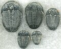 Trilobites first appeared during the Cambrian period and were among the most widespread and diverse groups of Paleozoic organisms. (from History of Earth)
 -
 An artist's impression of ice age Earth at glacial maximum. (from History of Earth)
 -
 Earth's axial tilt causing different angles of seasonal illumination at different orbital positions around the Sun (from Earth)
 -
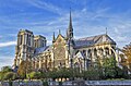 Notre-Dame de Paris, France
 -
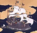 Japanese depiction of a Portuguese carrack. European maritime innovations led to proto-globalization.
 -
 Earth's night-side upper atmosphere appearing from the bottom as bands of afterglow illuminating the troposphere in orange with silhouettes of clouds, and the stratosphere in white and blue. Next the mesosphere (pink area) extends to the orange and faintly green line of the lowest airglow, at about one hundred kilometers at the edge of space and the lower edge of the thermosphere (invisible). Continuing with green and red bands of aurorae stretching over several hundred kilometers. (from Earth)
 -

-
An artist's impression of the Archean, the eon after Earth's formation, featuring round stromatolites, which are early oxygen-producing forms of life from billions of years ago. After the Late Heavy Bombardment, Earth's crust had cooled, its water-rich barren surface is marked by continents and volcanoes, with the Moon still orbiting Earth half as far as it is today, appearing 2.8 times larger and producing strong tides. (from Earth)
-
 An animation of the changing density of productive vegetation on land (low in brown; heavy in dark green) and phytoplankton at the ocean surface (low in purple; high in yellow) (from Earth)
 -
 Pangaea was a supercontinent that existed from about 300 to 180 Ma. The outlines of the modern continents and other landmasses are indicated on this map. (from History of Earth)
 -
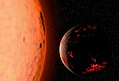
 Pale orange dot, an artist's impression of Early Earth, featuring its tinted orange methane-rich early atmosphere (from Earth)
 -
 Peopling of the world, the Southern Dispersal scenario
 -
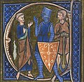 13th-century French historiated initial with the three classes of medieval society: those who prayed (the clergy), those who fought (the knights), and those who worked (the peasantry) (from Human history)
 -
 Artist's conception of Devonian flora (from History of Earth)
 -
The pale orange dot, an artist's impression of the early Earth which might have appeared orange through its hazy methane rich prebiotic second atmosphere. Earth's atmosphere at this stage was somewhat comparable to today's atmosphere of Titan. (from History of Earth)


Megacities of the world -

Chengdu is the capital city of the Chinese province of Sichuan. With a population of 20,937,757 at the 2020 census, it is the fourth most populous city in China, and it is the only city with a population of over 20 million apart from direct-administered municipalities. It is traditionally the hub of Western China.
Chengdu is in central Sichuan. The surrounding Chengdu Plain is known as the "Country of Heaven" and the "Land of Abundance." Its prehistoric settlers included the Sanxingdui culture. The site of Dujiangyan, an ancient irrigation system, is designated as a World Heritage Site. The Jin River flows through the city. Chengdu's culture largely reflects that of its province, Sichuan; in 2011, it was recognized by UNESCO as a city of gastronomy. It is associated with the giant panda, a Chinese national symbol, which inhabits the area of Sichuan; the city is home to the Chengdu Research Base of Giant Panda Breeding. (Full article...)Did you know -

- ... that despite losing his left arm in World War II, Austrian tennis player Hans Redl reached the fourth round at Wimbledon in 1947?
- ... that during the First World War, Adrian Becher received his second Military Cross for leading the defence of a position for five days, despite having been buried by a shell explosion on the first day?
- ... that J. R. R. Tolkien invented Elendil for a time-travel story, but ultimately included the character in his main Middle-earth mythology?
- ... that William Anders took the iconic photograph Earthrise?
- ... that the 1653 hymn "Du, o schönes Weltgebäude", about renouncing the world, contains the stanza "Komm, O Tod, du Schlafes Bruder", which Bach used to conclude his cross-staff cantata?
- ... that Frederick Perceval, 11th Earl of Egmont, was nicknamed "the loneliest boy in the world" by journalists?
- ... that footballer Han Bong-zin trained in the military every day for four years in preparation for the FIFA World Cup?
- ... that Fred Provo was told he would have to have his arm amputated due to a wound sustained in World War II, but refused, recovered, and went on to play in the National Football League?
Countries of the world -

Nauru (/nɑːˈuːruː/ nah-OO-roo or /ˈnaʊruː/ NOW-roo; Nauruan: Naoero), officially the Republic of Nauru (Nauruan: Repubrikin Naoero) and formerly known as Pleasant Island, is an island country and microstate in Micronesia, part of Oceania in the Central Pacific. Its nearest neighbour is Banaba of Kiribati, about 300 km (190 mi) to the east.
It lies northwest of Tuvalu, 1,300 km (810 mi) northeast of the Solomon Islands, east-northeast of Papua New Guinea, southeast of the Federated States of Micronesia and south of the Marshall Islands. With an area of only 21 km2 (8.1 sq mi), Nauru is the third-smallest country in the world, larger than only Vatican City and Monaco, making it the smallest republic and island nation, as well the smallest member state of the Commonwealth of Nations by area. Its population of about 10,800 is the world's third-smallest (not including colonies or overseas territories). Nauru is a member of the United Nations, the Commonwealth of Nations, and the Organization of African, Caribbean, and Pacific States. (Full article...)The Seven Wonders of Portuguese Origin in the World are a list of seven significant landmarks across the world which were built by the Portuguese during the six centuries of the Portuguese Empire (1415-1999). The competition was held in conjunction with the Ministry of Culture of Portugal and the Portuguese Institute for Architectural Heritage.
The objective of the list and competition was to promote the architectural heritage and legacy of the Portuguese across the world. A commission pre-selected 27 notable monuments of Portuguese origin from 16 countries across Asia, Africa, and the Americas. The results of the competition were announced at a ceremony at the Portugal Day celebrations in 2010. (Full article...)Related portals
Protected areas of the world -
-

Network of protected areas in Albania (2020)
Despite being a relatively small country, Albania is exceedingly rich in biodiversity. Its ecosystems and habitats support over 5,550 species of vascular and non-vascular plants and more than 15,600 species of coniferous and non-coniferous evergreens, most of which are threatened at global and European levels. The country has made recent efforts to expand its network of protected areas which now include: 11 national parks, 1 marine park, 718 nature monuments, 23 managed nature reserves, 11 protected landscapes, 4 World Heritage Sites, 4 Ramsar sites and other protected areas of various categories, that when combined, account for 21.36% of the territory. Furthermore, a biosphere reserve, 45 important plant areas and 16 important bird areas are found in the country.
Meanwhile, the central government has proclaimed the Coastline and the Tirana Greenbelt as areas of national importance. (Full article...) -

West Matukituki Valley and the Matukituki River seen from Cascade Saddle in Mount Aspiring National Park
Protected areas of New Zealand are areas that are in some way protected to preserve their environmental, scientific, scenic, historical, cultural or recreational value. There are about 10,000 protected areas, covering about a third of the country. The method and aims of protection vary according to the importance of the resource and whether it is publicly or privately owned.
Nearly 30 percent of New Zealand's land mass is publicly owned with some degree of protection. Most of this land – about 80,000 square kilometres (31,000 sq mi) – is administered by the Department of Conservation. There are 13 national parks, thousands of reserves, 54 conservation parks, and a range of other conservation areas. (Full article...) -
Protected areas of Slovakia are areas that need protection because of their environmental, historical or cultural value to the nation. Protected areas in Slovakia are managed by institutions and organizations governed by the Ministry of the Environment.
Types of protected areas:- National Park (Slovak: Národný park; abbr. NP)
- Protected Landscape Area (Chránená krajinná oblasť; CHKO)
- National Nature Reserve (Národná prírodná rezervácia; NPR)
- Nature Reserve (Prírodná rezervácia; PR)
- National Nature Monument (Národná prírodná pamiatka; NPP)
- Nature Monument (Prírodná pamiatka; PP)
- Protected Site (Chránený areál; CHA)
- Protected Landscape Element (Chránený krajinný prvok; CHKP)
- Protected Bird Area* (Chránené vtáčie územie; CHVÚ) *Technically Special Protection Area (SPA) under the EU Bird's Directive
- Protected Tree (Chránený strom; CHS)
-
There are four categories of protected areas in India, constituted under the Wildlife Protection Act, 1972. Tiger reserves consist of areas under national parks and wildlife sanctuaries. There are 53 tiger reserves in India. the protected areas of India cover 173,629.52 square kilometres (67,038.73 sq mi), roughly 5.28% of the total geographical area of the country. (Full article...)
-
This is a list of protected areas of Romania.
About 5.18% of the area of Romania has a protected status (12,360 km2), including the Danube Delta, which makes half of these areas (2.43% of Romania's area). (Full article...) -
The Protected areas of Kyrgyzstan are regulated by the law on specially protected natural areas of 2 May 2011, last modified on 2 June 2018. In total, they cover 14,761.216 km2 (5,699.337 sq mi) and account for 7.38% of the country's total area (as of 2017). The first protected area in Kyrgyzstan (Issyk-Kul) was established in 1948. According to the Government Decree on Priorities of Conservation of Biological Diversity and the relevant Action Plan for 2014-2024 the target area for the protected areas in Kyrgyzstan is 10 percent of the country’s area by 2024.
The protected areas are subdivided into seven categories: (Full article...) -

Map of protected areas of the Czech Republic: national parks (grey) and protected landscape areas (green)
There are several types of protected areas of the Czech Republic. The main form of landscape protection is delimitation of special protected areas. All the types of protected areas are determined by law. (Full article...) -

Upolu Island, Samoa
This is a list of some protected areas of Samoa which include national parks, reservations, protected nature zones, marine reserves and other areas of significant biodiversity and conservation.
In 1994, Samoa ratified the international and legally binding treaty, the Convention on Biological Diversity to develop national strategies for conservation and sustainable use of biological diversity. In 2010, protected areas in the country cover 5% of land although the government aims to increase protected areas coverage to 15%. (Full article...) -
This is a list of protected areas of Afghanistan.
- Ab-i-Estada Nature Reserve, Ghazni Province
- Ajar Valley Nature Reserve, Bamyan Province
- Bamiyan National Heritage Park, Bamyan Province
- Bamiyan Plateau Protected Landscape, Bamyan Province
- Band-e Amir National Park, Bamyan Province
- Darqad (Takhar) Wildlife Reserve, Takhar Province
- Dasht-i-Nawar Waterfowl Sanctuary, Ghazni Province
- Hamun-i-Puzak Waterfowl Sanctuary, Farah and Nimroz provinces
- Imam Sahib (Kunduz) Wildlife Reserve, Kunduz Province
- Khulm Landmark Protected Area, Balkh Province
- Koh-e Baba (Shah Foladi) Protected Landscape, Bamyan province
- Kol-i-Hashmat Khan Waterfowl Sanctuary, Kabul Province
- Northwest Afghanistan Game Managed Reserve, Herat Province
- Nuristan National Park and Wildlife Reserve, Nuristan Province
- Pamir-i-Buzurg Wildlife Reserve, Badakhshan Province
- Registan Desert Wildlife Managed Reserve, Kandahar Province
- Wakhan National Park, Badakhshan Province
- Zadran National Reserve, Paktia Province
-
This list of protected areas of Quebec includes federally, provincially and municipally administered parks and wildlife reserves in Quebec, the largest province in Canada. (Full article...) -
-
-
This list of protected areas of Manitoba groups the protected areas of Manitoba by the agency that is responsible for their protection. (Full article...)
-
A list of protected areas of Oman:
- Al Wusta Wildlife Reserve
- Ra's Al Hadd Turtle Reserve
- Ad Dimaniyat Islands Reserve
- Al Saleel National Park (As Salil Natural Park)
- Jabal Samhan Nature Reserve
- Al Jabal Al Akhdar Scenic Reserve
- Western Hajer Stars Lights Reserve
- Arabian Oryx Sanctuary
- Al Rustaq Wildlife Reserve
- Al Wusta Wetland Reserve
- Jabal Qahwan Nature Reserve
- Al Sareen Nature Reserve
- Ras al Shajar Nature Reserve
- Al Khuwuair Nature Reserve
- Khawrs of the Salalah Coast Reserve
-
Kentucky's system of 44 state parks has been referred to as "the nation's finest" and experiences more repeat business annually than those of any other U.S. state. The state's diverse geography provides a variety of environments to experience. From mountain lakes to expansive caves to forests teeming with wildlife, park-goers have their choice of attractions, and they are all within a day's drive of each other.
Unless otherwise specified, data in the following lists are taken from Kentucky State Parks by Bill Bailey. (Full article...)


Selected world maps
-
 Only a few of the largest large igneous provinces appear (coloured dark purple) on this geological map, which depicts crustal geologic provinces as seen in seismic refraction data
 -
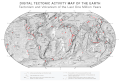 A plate tectonics map with volcano locations indicated with red circles
 -
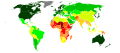 United Nations Human Development Index map by country (2016)
 -
 Mollweide projection of the world
 -
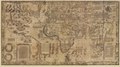 1516 map of the world by Martin Waldseemüller
 -
 Index map from the International Map of the World (1:1,000,000 scale)
 -
 The world map by Gerardus Mercator (1569), the first map in the well-known Mercator projection
 -
 The Goode homolosine projection is a pseudocylindrical, equal-area, composite map projection used for world maps.
 -
 Time zones of the world


World records
- List of Olympic records in athletics
- List of world records in athletics
- List of junior world records in athletics
- List of world records in masters athletics
- List of world youth bests in athletics
- List of IPC world records in athletics
- List of world records in canoeing
- List of world records in chess
- List of cycling records
- List of world records in track cycling
- List of world records in finswimming
- List of world records in juggling
- List of world records in rowing
- List of world records in speed skating
- List of world records in swimming
- List of IPC world records in swimming
- List of world records in Olympic weightlifting
Topics

Continents of Earth | ||||||||
|---|---|---|---|---|---|---|---|---|
| ||||||||
| ||||||||
| ||||||||


| Cenozoic Era (present–66.0 Ma) |
| ||||||||||||
|---|---|---|---|---|---|---|---|---|---|---|---|---|---|
| Mesozoic Era (66.0–252 Ma) |
| ||||||||||||
| Paleozoic Era (252–539 Ma) |
| ||||||||||||
| Proterozoic Eon (539 Ma–2.5 Ga) |
| ||||||||||||
| Archean Eon (2.5–4 Ga) | |||||||||||||
| Hadean Eon (4–4.6 Ga) | |||||||||||||
ka = kiloannum (thousands years ago); Ma = megaannum (millions years ago); Ga = gigaannum (billions years ago). See also: Geologic time scale • | |||||||||||||
| Locations | ||
|---|---|---|
| Related | ||

| |||||||||||||||||||
| |||||||||||||||||||
| |||||||||||||||||||

Economic classification of countries | |||||
|---|---|---|---|---|---|
| Three-World Model | |||||
| Gross domestic product (GDP) |
| ||||
| Gross national income (GNI) | |||||
| Wages | |||||
| Wealth | |||||
| Other national accounts | |||||
| Human development | |||||
| Digital divide | |||||
| Net international investment position (NIIP) | |||||
| Technological |
| ||||
|---|---|---|---|---|---|
| Sociological | |||||
| Ecological |
| ||||
| Biological |
| ||||
| Astronomical | |||||
| Eschatological |
| ||||
| Others |
| ||||
| Fictional | |||||
| Organizations | |||||
Categories

Wikimedia
The following Wikimedia Foundation sister projects provide more on this subject:
-
 Commons
Free media repository -
 Wikibooks
Free textbooks and manuals -
 Wikidata
Free knowledge base -
 Wikinews
Free-content news -
 Wikiquote
Collection of quotations -
 Wikisource
Free-content library -
 Wikispecies
Directory of species -
 Wikiversity
Free learning tools -
 Wikivoyage
Free travel guide -
 Wiktionary
Dictionary and thesaurus


