Arctic Ocean
 The Arctic is a region above 66 degrees and 33 minutes north. Eight coastal countries have territorial and maritime rights. The name Arctic comes from the Greek word "arktikos" meaning "near the bear" or "northern," and that word derives from "arktos," meaning "bear". The name refers either to the constellation Ursa Major, the "Great Bear," which is prominent in the northern celestial sphere, or to the constellation Ursa Minor, the "Little Bear," which contains Polaris, the North (Pole) Star.
Tempting as it may be to view the Arctic through the prism of great-power competition—which undoubtedly would fit with Russia’s quest for recognition as a great power—there is little to suggest that Russia’s military posture in the Arctic is a fundamentally new undertaking, write Eugene Rumer, Richard Sokolsky and Paul Stronski of the Carnegie Endowment for International Peace.
The struggle for the Arctic began in the 20th century, when the Arctic states began to claim their rights to the Arctic territories up to the North Pole. Thus, by the mid-1920s, the Arctic was actually divided between the USA, USSR, Norway, Canada and Denmark on a sectoral basis - the point of the North Pole was the border of the states concerned.
It is generally believed that the dispute over the Arctic "flared up" on August 3, 2007, when the crew of the Mir-1 submarine, which consisted of three people, planted a titanium Russian flag on the seabed over the North Pole. The international reaction following the global spread of the blurry flag photograph was expressed by then Canadian Foreign Minister Peter McKay: “This is not the fifteenth century. You cannot travel around the world, place flags and say, "We are claiming this territory." But the famous flag-planting event was funded by the Swedish pharmaceutical magnate Frederick Paulsen and was organized by the Australian-American group of deep-sea enthusiasts. research. In other words, the move, which angered Canada's foreign minister and focused international media attention on a "new cold war," was unlikely to have been specially prepared for research in support of Russia's claims to the Lomonosov Ridge or as evidence of territorial gains.
Russia considers its 18 percent of the Arctic territory with a border length equal to 20 thousand kilometers. Its continental shelf may contain about a quarter of all offshore hydrocarbon reserves in the world. Currently, 22 percent of all Russian exports are produced in the Arctic region. The largest oil and gas regions are located here - West Siberian, Timan-Pechora and East Siberian. The extraction of rare and precious metals is developed in the Arctic regions. The region produces about 90 percent of nickel and cobalt, 60 percent of copper, 96 percent of platinoids.
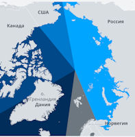
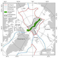
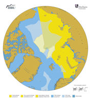
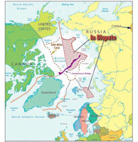
The Convention on the Law of the Sea (Article 76) provides for the possibility of extending the exclusive economic zone beyond 200 miles if the state proves that the ocean floor is a natural extension of its land territory. Bearing in mind this article of the convention, today scientists from three countries - Russia, Denmark and Canada - are trying to collect geological evidence that the Lomonosov Ridge - an underwater mountain range stretching 1,800 km from Siberia through the North Pole to Greenland - belongs to their country. Russian geologists claim, referring to the analysis of samples taken from the bottom of the ocean, that the Lomonosov Ridge is connected with the Siberian continental platform (which means that it is a "continuation" of Russia). The Danes, in turn, believe that the ridge is connected with Greenland.
On December 15, 2014, Denmark applied for as much as 895,000 square kilometers of shelf north of Greenland (for reference, Greenland is an autonomy that is part of Denmark). Considering that the application mentions the entire Lomonosov ridge and the North Pole itself, then little Denmark's appetites are rather big, in a word. Danish Foreign Minister Martin Lidegard announced that Copenhagen is submitting an application to the UN for the recognition of a significant part of the Arctic shelf belonging to Greenland (an autonomous territory of the kingdom). The area of territorial claims is about 895,000 square km - 21 times the area of Denmark itself and includes the North Pole and the entire Lomonosov ridge.
Canada in turn presented its submission to the UN in 2019. Adam Lajeunesse of St Francis Xavier University noted in response that, “There was [some conjecture] that we would sort of do a quid pro quo and stop our claim at about the pole as a means of facilitating a political settlement. But like the Danes, we’ve gone well over the North Pole and are claiming an enormous chunk of the Arctic continental shelf.”
Canadian and Danish scientists launched a joint exploration mission in March 2020 to define the boundaries of the North American continental shelf. They were going to camp on Ward Hunt Island, the northernmost point of Canada, from where the expedition started. From this island, one group of scientists makes flights in a helicopter equipped with sonar. The second group, on a specially equipped DC-3 aircraft with a range of about 800 kilometers, will carry out gravimetric measurements in the Arctic territory, including at the North Pole (gravimetry is the measurement of the slightest fluctuations in gravity to obtain information about the density of rocks at different points on the surface and their geological properties).
Using this method, Canadian and Danish scientists want to get evidence that the North American continental plate, which includes the northern Canadian islands and Greenland (an autonomous province of Denmark), extends far into the center of the Arctic Ocean. This will mean that the continuation of the North American continental platform is the underwater Lomonosov Ridge and the parallel Alpha Ridge, which turns into the Mendeleev Ridge in the east.
It should be noted that in international law there were precedents for the expansion of rights to the continental shelf beyond the boundaries of the 200-mile exclusive economic zone. The UN Commission on the Limits of the Continental Shelf has already legalized Australia's claims to 2.5 million square kilometers of the Antarctic shelf, and Ireland received 56 thousand square kilometers of shelf in the Arctic latitudes. Of course, it is necessary to rely on the fairness of the UN Commission's decision regarding the dispute over the Arctic territories (the Lomonosov Ridge, etc.), taking into account the fact that all decisions in the world community are nevertheless taken with an eye to the balance of military and economic potentials of the parties.
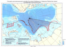
Russia made ambitious territorial claims in the Arctic, through legal channels in compliance with the United Nations (UN) Convention on the Law of the Sea, which Russia has signed and ratified, unlike the United States. On 31 March 2021, the Russian Federation submitted two Addenda to the 2015 partial revised Submission to the Commission on the Limits of the Continental Shelf in respect of the Arctic Ocean. Russia formally enlarged its claim to the seabed in the Arctic Ocean all the way to Canada’s and Greenland’s exclusive economic zones. Notably, Russia did not extended its claim into waters north of Alaska that are known to be part of the U.S. sphere of interests, Russia’s rights to the seabed would begin right outside Canada’s and Greenland’s exclusive economic zones 200 nautical miles from shore. The Russian enlargement significantly increased the overlap between Russia’s claims and the claims of Canada and Denmark. Russia would have exclusive rights to all resources on the seabed, but, importantly, not in the water column, on the surface, or in the airspace above. Also, Russia would command certain rights to regulate traffic in the area in order to protect its resources.
“This is a maximalist submission. You cannot claim any more,” complains Robert Huebert, an Arctic expert at the University of Calgary. “In effect, they’re claiming the entire Arctic Ocean as their continental shelf … they’re claiming the entire Canadian and Danish continental shelf as their continental shelf,” adds Huebert.
The Arctic Ocean is the smallest of the world's five oceans (after the Pacific Ocean, Atlantic Ocean, Indian Ocean, and the Southern Ocean). The Northwest Passage (US and Canada) and Northern Sea Route (Norway and Russia) are two important seasonal waterways. In recent years the polar ice pack has receded in the summer allowing for increased navigation and raising the possibility of future sovereignty and shipping disputes among the six countries bordering the Arctic Ocean (Canada, Denmark (Greenland), Iceland, Norway, Russia, US).
The polar climate is characterized by persistent cold and relatively narrow annual temperature range. Winters are characterized by continuous darkness, cold and stable weather conditions, and clear skies. Summers are characterized by continuous daylight, damp and foggy weather, and weak cyclones with rain or snow. The maximum snow cover in March or April is about 20 to 50 centimeters over the frozen ocean, and lasts about 10 months.
The central surface is covered by a perennial drifting polar icepack that, on average, is about 3 m thick, although pressure ridges may be three times that thickness. The icepack is surrounded by open seas during the summer, but more than doubles in size during the winter and extends to the encircling landmasses. The ocean floor is about 50% continental shelf (highest percentage of any ocean) with the remainder a central basin interrupted by three submarine ridges (Alpha Cordillera, Nansen Cordillera, and Lomonosov Ridge).
There are major surface currents. Two major, slow-moving, wind-driven currents (drift streams) dominate: a clockwise drift pattern in the Beaufort Gyre in the western part of the Arctic Ocean and a nearly straight line Transpolar Drift Stream that moves across the ocean from the New Siberian Islands (Russia) to the Fram Strait (between Greenland and Svalbard). Sea ice that lies close to the center of the gyre can complete a 360 degree circle in about 2 years, while ice on the gyre periphery will complete the same circle in about 7-8 years. Sea ice in the Transpolar Drift crosses the ocean in about 3 years.
The major chokepoint is the southern Chukchi Sea (northern access to the Pacific Ocean via the Bering Strait). This strategic location between North America and Russia is shortest marine link between the extremes of eastern and western Russia. There are floating research stations operated by the US and Russia.
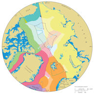
Canada, Russia, the US, Denmark [via Greenland] and Norway are staking claims in the Arctic Ocean, which may contain a quarter of the world's untapped petroleum reserves, and is becoming more accessible due to global warming. Under the Convention on the Law of the Sea, they could acquire rights to Arctic seafloor territory if the areas are linked to their continental shelves. Russia made its claim in 2001, though it will make a resubmission. Canada ratified the Law on the Sea in 2003, so it had to file its claim by 2013. The United States had not ratified the Law of the Sea Convention.
The climate in the Arctic is changing faster than in mid-latitudes. This is shown by increased temperatures, loss of summer sea ice, earlier snow melt, impacts on ecosystems, and increased economic access. Arctic sea ice volume has decreased by 75% since the 1980s. Long-lasting global anthropogenic forcing from carbon dioxide has increased over the previous decades and is anticipated to increase over the next decades. Temperature increases in response to greenhouse gases are amplified in the Arctic through feedback processes associated with shifts in albedo, ocean and land heat storage, and near-surface longwave radiation fluxes.
In response to increased Arctic shipping traffic, on 25 January 2018 the United States and Russian Federation proposed a system of two-way routes for vessels to follow in the Bering Strait and Bering Sea. The nations jointly developed and submitted the proposal to the International Maritime Organization to establish six two-way routes and six precautionary areas. Located in U.S. and Russian Federation territorial waters off the coasts of Alaska and Russia’s Chukotskiy Peninsula, the routes are being recommended to help ships avoid the numerous shoals, reefs and islands outside the routes and to reduce the potential for marine casualties and environmental disasters.
The proposed two-way routes will be voluntary for all domestic and international ships. No additional aids to navigation are being proposed to mark the recommended two-way routes and the routing measures do not limit commercial fishing or subsistence activities.
“Over the past decade, the U.S. and Russia have both observed a steady increase in Arctic shipping activity,” said Mike Sollosi, the chief of the U.S. Coast Guard Navigation Standards Division. Increased commercial and recreational traffic bring the increased risk of maritime casualties, Sollosi said, and the bilateral proposal for routing measures is designed to reduce that risk. “The U.S. Coast Guard is engaging international and interagency partners across borders in developing joint proposals for ship routes in waterways that we share,” he said.
|
NEWSLETTER
|
| Join the GlobalSecurity.org mailing list |
|
|
|


