
Saint-Rustice
Saint-Rustice | |
|---|---|
 Saint-Rustice | |
Location of Saint-Rustice  | |
 Saint-Rustice  Saint-Rustice | |
| Coordinates: 43°48′23″N 1°19′43″E / 43.8064°N 1.3286°E | |
| Country | France |
| Region | Occitania |
| Department | Haute-Garonne |
| Arrondissement | Toulouse |
| Canton | Villemur-sur-Tarn |
| Government | |
| • Mayor (2020–2026) | Edmond Aussel[1] |
| Area 1 | 2.36 km2 (0.91 sq mi) |
| Population (2021)[2] | 430 |
| • Density | 180/km2 (470/sq mi) |
| Time zone | UTC+01:00 (CET) |
| • Summer (DST) | UTC+02:00 (CEST) |
| INSEE/Postal code | 31515 /31620 |
| Elevation | 107–217 m (351–712 ft) (avg. 108 m or 354 ft) |
| 1 French Land Register data, which excludes lakes, ponds, glaciers > 1 km2 (0.386 sq mi or 247 acres) and river estuaries. | |
Saint-Rustice (French pronunciation: [sɛ̃ ʁystis]; Occitan: Sent Rostesi) is a commune in the Haute-Garonne department in southwestern France.
History
Saint-Rustice is famous for its ancient Roman mosaics which were discovered in 1833. The city takes its name from Rusticus, a bishop of Cahors, who was murdered in 630.
Population
| Year | Pop. | ±% |
|---|---|---|
| 1962 | 225 | — |
| 1968 | 230 | +2.2% |
| 1975 | 233 | +1.3% |
| 1982 | 371 | +59.2% |
| 1990 | 394 | +6.2% |
| 1999 | 425 | +7.9% |
| 2008 | 432 | +1.6% |
Sights
-
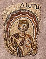 Gallo-Roman mosaic
 -
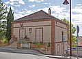 Town Hall
 -
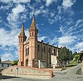 St. Peter Church
 -
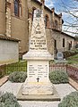 War memorial


See also
References
- ^ "Répertoire national des élus: les maires". data.gouv.fr, Plateforme ouverte des données publiques françaises (in French). 2 December 2020.
- ^ "Populations légales 2021" (in French). The National Institute of Statistics and Economic Studies. 28 December 2023.
Wikimedia Commons has media related to Saint-Rustice.
| Authority control databases: National |
|---|
This Haute-Garonne geographical article is a stub. You can help Wikipedia by expanding it. |