
Saint-Marcel-Paulel
Saint-Marcel-Paulel | |
|---|---|
 The town hall in Saint-Marcel-Paulel | |
 Coat of arms | |
Location of Saint-Marcel-Paulel  | |
 Saint-Marcel-Paulel  Saint-Marcel-Paulel | |
| Coordinates: 43°39′45″N 1°36′20″E / 43.6625°N 1.6056°E | |
| Country | France |
| Region | Occitania |
| Department | Haute-Garonne |
| Arrondissement | Toulouse |
| Canton | Pechbonnieu |
| Government | |
| • Mayor (2020–2026) | Véronique Rabanel[1] |
| Area 1 | 7.1 km2 (2.7 sq mi) |
| Population (2021)[2] | 467 |
| • Density | 66/km2 (170/sq mi) |
| Time zone | UTC+01:00 (CET) |
| • Summer (DST) | UTC+02:00 (CEST) |
| INSEE/Postal code | 31501 /31590 |
| Elevation | 143–230 m (469–755 ft) (avg. 180 m or 590 ft) |
| 1 French Land Register data, which excludes lakes, ponds, glaciers > 1 km2 (0.386 sq mi or 247 acres) and river estuaries. | |
Saint-Marcel-Paulel (French pronunciation: [sɛ̃ maʁsɛl polɛl]; Occitan: Sent Marcèl e Paulèl) is a commune in the Haute-Garonne department in southwestern France.
Population
| Year | Pop. | ±% |
|---|---|---|
| 1962 | 211 | — |
| 1968 | 213 | +0.9% |
| 1975 | 215 | +0.9% |
| 1982 | 277 | +28.8% |
| 1990 | 345 | +24.5% |
| 1999 | 401 | +16.2% |
| 2004 | 427 | +6.5% |
| 2008 | 441 | +3.3% |
| 2009 | 442 | +0.2% |
| 2014 | 404 | −8.6% |
| 2015 | 397 | −1.7% |
| 2018 | 420 | +5.8% |
The inhabitants of the commune are known as Marcellois.
Monuments
-
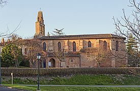 Church Saint-Pierre
 -
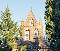 Bell gable
 -
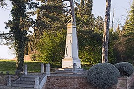 War memorial


See also
References
- ^ "Répertoire national des élus: les maires" (in French). data.gouv.fr, Plateforme ouverte des données publiques françaises. 13 September 2022.
- ^ "Populations légales 2021" (in French). The National Institute of Statistics and Economic Studies. 28 December 2023.
Wikimedia Commons has media related to Saint-Marcel-Paulel.
| Authority control databases: National |
|---|
This Haute-Garonne geographical article is a stub. You can help Wikipedia by expanding it. |