
Saint-Cézert
Saint-Cézert | |
|---|---|
 The village square in Saint-Cézert | |
Location of Saint-Cézert  | |
 Saint-Cézert  Saint-Cézert | |
| Coordinates: 43°46′57″N 1°11′43″E / 43.7825°N 1.1953°E | |
| Country | France |
| Region | Occitania |
| Department | Haute-Garonne |
| Arrondissement | Toulouse |
| Canton | Léguevin |
| Government | |
| • Mayor (2020–2026) | Henri Oliveira Soares[1] |
| Area 1 | 8.94 km2 (3.45 sq mi) |
| Population (2021)[2] | 440 |
| • Density | 49/km2 (130/sq mi) |
| Time zone | UTC+01:00 (CET) |
| • Summer (DST) | UTC+02:00 (CEST) |
| INSEE/Postal code | 31473 /31330 |
| Elevation | 125–173 m (410–568 ft) (avg. 160 m or 520 ft) |
| 1 French Land Register data, which excludes lakes, ponds, glaciers > 1 km2 (0.386 sq mi or 247 acres) and river estuaries. | |
Saint-Cézert (French pronunciation: [sɛ̃ sezɛʁ]; Occitan: Sent Cesèrt) is a commune in the Haute-Garonne department in southwestern France.
Population
| Year | Pop. | ±% |
|---|---|---|
| 1962 | 172 | — |
| 1968 | 221 | +28.5% |
| 1975 | 188 | −14.9% |
| 1982 | 329 | +75.0% |
| 1990 | 402 | +22.2% |
| 1999 | 413 | +2.7% |
| 2008 | 340 | −17.7% |
Sights
-
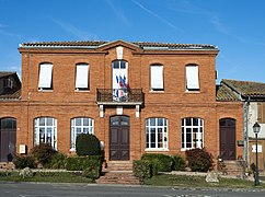 Town hall
 -
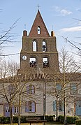 Church


See also
References
- ^ "Répertoire national des élus: les maires". data.gouv.fr, Plateforme ouverte des données publiques françaises (in French). 9 August 2021.
- ^ "Populations légales 2021" (in French). The National Institute of Statistics and Economic Studies. 28 December 2023.
Wikimedia Commons has media related to Saint-Cézert.
| Authority control databases: National |
|---|
This Haute-Garonne geographical article is a stub. You can help Wikipedia by expanding it. |