
Laréole
Laréole | |
|---|---|
 The chateau in Laréole | |
Location of Laréole  | |
 Laréole  Laréole | |
| Coordinates: 43°44′20″N 1°01′23″E / 43.7389°N 1.0231°E | |
| Country | France |
| Region | Occitania |
| Department | Haute-Garonne |
| Arrondissement | Toulouse |
| Canton | Léguevin |
| Intercommunality | Hauts Tolosans |
| Government | |
| • Mayor (2020–2026) | Fabien Gauthe[1] |
| Area 1 | 8.88 km2 (3.43 sq mi) |
| Population (2021)[2] | 160 |
| • Density | 18/km2 (47/sq mi) |
| Time zone | UTC+01:00 (CET) |
| • Summer (DST) | UTC+02:00 (CEST) |
| INSEE/Postal code | 31275 /31480 |
| Elevation | 135–272 m (443–892 ft) (avg. 235 m or 771 ft) |
| 1 French Land Register data, which excludes lakes, ponds, glaciers > 1 km2 (0.386 sq mi or 247 acres) and river estuaries. | |
Laréole (French pronunciation: [laʁeɔl]; Occitan: La Reula) is a commune in the Haute-Garonne department in southwestern France.
Population
| Year | Pop. | ±% |
|---|---|---|
| 1962 | 121 | — |
| 1968 | 152 | +25.6% |
| 1975 | 146 | −3.9% |
| 1982 | 138 | −5.5% |
| 1990 | 114 | −17.4% |
| 1999 | 122 | +7.0% |
| 2008 | 137 | +12.3% |
Monuments
-
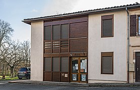 The town hall; The church; The castle
 -
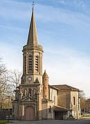 The church Notre-Dame;
 -
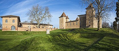 The castle


See also
References
- ^ "Répertoire national des élus: les maires". data.gouv.fr, Plateforme ouverte des données publiques françaises (in French). 2 December 2020.
- ^ "Populations légales 2021" (in French). The National Institute of Statistics and Economic Studies. 28 December 2023.
Wikimedia Commons has media related to Laréole.
| Authority control databases: National |
|---|
This Haute-Garonne geographical article is a stub. You can help Wikipedia by expanding it. |