Aleyrac: Difference between revisions
Appearance
Content deleted Content added
ibx param |
No edit summary |
||
| Line 7: | Line 7: | ||
|coordinates = {{coord|44.4997|4.9389|format=dms|display=inline,title}} |
|coordinates = {{coord|44.4997|4.9389|format=dms|display=inline,title}} |
||
|arrondissement = Nyons |
|arrondissement = Nyons |
||
|intercommunality = |
|intercommunality = [[Communauté de communes Dieulefit-Bourdeaux|Dieulefit-Bourdeaux]] |
||
|mayor = Dominique Arnaud |
|mayor = Dominique Arnaud |
||
|term = 2014-2020 |
|term = 2014-2020 |
||
| Line 14: | Line 14: | ||
|area km2 = 6.65 |
|area km2 = 6.65 |
||
|population = 46 |
|population = 46 |
||
|population date = |
|population date = 2016 |
||
|INSEE = 26003 |
|INSEE = 26003 |
||
|postal code = 26770 |
|postal code = 26770 |
||
Revision as of 14:54, 25 February 2019
Aleyrac | |
|---|---|
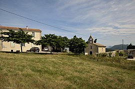
 The town hall and church | |
| Coordinates: 44°29′59″N 4°56′20″E / 44.4997°N 4.9389°E | |
| Country | France |
| Region | Auvergne-Rhône-Alpes |
| Department | Drôme |
| Arrondissement | Nyons |
| Canton | Dieulefit |
| Intercommunality | Dieulefit-Bourdeaux |
| Government | |
| • Mayor (2014-2020) | Dominique Arnaud |
| Area 1 | 6.65 km2 (2.57 sq mi) |
| Population (2016) | 46 |
| • Density | 6.9/km2 (18/sq mi) |
| Time zone | UTC+01:00 (CET) |
| • Summer (DST) | UTC+02:00 (CEST) |
| INSEE/Postal code | 26003 /26770 |
| Elevation | 318–571 m (1,043–1,873 ft) |
| 1 French Land Register data, which excludes lakes, ponds, glaciers > 1 km2 (0.386 sq mi or 247 acres) and river estuaries. | |
Aleyrac is a commune in the Drôme department in southeastern France.
Population
| Year | Pop. | ±% |
|---|---|---|
| 1911 | 70 | — |
| 1962 | 30 | −57.1% |
| 1968 | 32 | +6.7% |
| 1975 | 33 | +3.1% |
| 1982 | 29 | −12.1% |
| 1990 | 39 | +34.5% |
| 1999 | 45 | +15.4% |
| 2008 | 48 | +6.7% |
See also
References
Wikimedia Commons has media related to Aleyrac.


