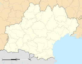
Antichan-de-Frontignes: Difference between revisions
m r2.7.2) (robot Removing: nap:Antichan-de-Frontignes |
mNo edit summary |
||
| (40 intermediate revisions by 22 users not shown) | |||
| Line 1: | Line 1: | ||
{{Use dmy dates|date=August 2023}} |
|||
{{Infobox French commune |
{{Infobox French commune |
||
|name = Antichan-de-Frontignes |
|name = Antichan-de-Frontignes |
||
| |
|commune status = [[Communes of France|Commune]] |
||
| |
|image = Antichan-de-Frontignes General View.JPG |
||
| |
|caption = A general view of Antichan-de-Frontignes |
||
| |
|arrondissement = Saint-Gaudens |
||
|canton = Bagnères-de-Luchon |
|||
|INSEE = 31009 |
|INSEE = 31009 |
||
|postal code = 31510 |
|postal code = 31510 |
||
|mayor = Bernard Dumail<ref>{{cite web|title=Répertoire national des élus: les maires|url=https://www.data.gouv.fr/fr/datasets/r/2876a346-d50c-4911-934e-19ee07b0e503|publisher=data.gouv.fr, Plateforme ouverte des données publiques françaises|date=13 September 2022|language=fr}}</ref> |
|||
|mayor = Bernard Dumail |
|||
|term = |
|term = 2020–2026 |
||
|intercommunality = |
|intercommunality = Pyrénées Haut Garonnaises |
||
| |
|coordinates = {{coord|42.9742|0.6661|format=dms|display=inline,title}} |
||
|latitude = 42.9741666667 |
|||
|elevation m = 600 |
|elevation m = 600 |
||
|elevation min m = 533 |
|elevation min m = 533 |
||
|elevation max m = 1655 |
|elevation max m = 1655 |
||
|area km2 = 4.27 |
|area km2 = 4.27 |
||
|population = |
|population = {{France metadata Wikidata|population_total}} |
||
|population date = |
|population date = {{France metadata Wikidata|population_as_of}} |
||
|population footnotes = {{France metadata Wikidata|population_footnotes}} |
|||
}} |
}} |
||
'''Antichan-de-Frontignes''' is a [[Communes of France|commune]] in the [[Haute-Garonne]] [[Departments of France|department]] in south-western [[France]]. |
'''Antichan-de-Frontignes''' ({{IPA-fr|ɑ̃tiʃɑ̃ də fʁɔ̃tiɲ}}; {{lang-oc|Antishan de Frontinhas}}) is a [[Communes of France|commune]] in the [[Haute-Garonne]] [[Departments of France|department]] in the [[Occitania (administrative region)|Occitanie]] region of south-western [[France]]. |
||
==Geography== |
|||
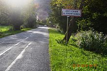
[[File:Antichan-de-Frontignes Entry.JPG|thumb|left|Entry to Antichan-de-Frontignes]] |
|||
Antichan-de-Frontignes is located at the foot of the [[Pyrenees]] in the [[Comminges]] region some 40 km east by south-east of [[Bagnères-de-Bigorre]] and 19 km south by south-west of [[Saint-Gaudens, Haute-Garonne|Saint-Gaudens]]. Access to the commune is by the D618 road which branches from the D331 east of [[Ore, Haute-Garonne|Ore]] and goes to the village then continues north-east by a roundabout route to [[Juzet-d'Izaut]]. There is also a local road going from the D618 north of the village to [[Saint-Pé-d'Ardet]]. Most of the commune is heavily forested however there is some farmland near the village.<ref name=Google>[https://www.google.com/maps/place/Antichan-de-Frontignes,+France/@42.9663376,0.6759192,3420m/data=!3m1!1e3!4m2!3m1!1s0x12a8f6cd990c4841:0x406f69c2f413200?hl=en Google Maps]</ref> |
|||
===Neighbouring communes and villages=== |
|||
{{Geographic location |
|||
|width=auto |
|||
|Centre = Antichan-de-Frontignes |
|||
|North = [[Saint-Pé-d'Ardet]] |
|||
|Northeast = [[Moncaup, Haute-Garonne|Moncaup]] |
|||
|East = [[Arguenos]] |
|||
|Southeast = |
|||
|South = [[Bezins-Garraux]] |
|||
|Southwest = [[Frontignan-de-Comminges]] |
|||
|West = [[Ore, Haute-Garonne|Ore]] |
|||
|Northwest = [[Lourde, Haute-Garonne|Lourde]] |
|||
}} |
|||
<ref name=Google/> |
|||
==Administration== |
|||
{{incomplete list|date=April 2021}} |
|||
'''List of Successive Mayors'''<ref>[http://www.francegenweb.org/mairesgenweb/resultcommune.php?id=25356 List of Mayors of France] {{in lang|fr}}</ref> |
|||
{| class="wikitable" |
|||
|- |
|||
! From !! To !! Name |
|||
|- |
|||
| 2001 || 2026 || Bernard Dumail |
|||
|} |
|||
==Demography== |
|||
The inhabitants of the commune are known as ''Antichanais'' or ''Antichanaises'' in French.<ref>[https://www.habitants.fr/haute-garonne-31 Le nom des habitants du 31 - Haute-Garonne], habitants.fr</ref> |
|||
{{Historical populations |
|||
| align = none |
|||
| cols = 2 |
|||
| percentages = pagr |
|||
| source = EHESS<ref name=ehess>{{Cassini-Ehess|1996|Antichan-de-Frontignes}}</ref> and INSEE<ref name=pophist>[https://www.insee.fr/fr/statistiques/4515315?geo=COM-31009#ancre-POP_T1 Population en historique depuis 1968], INSEE</ref> |
|||
|1793 |241 |
|||
|1800 |250 |
|||
|1806 |242 |
|||
|1821 |288 |
|||
|1831 |349 |
|||
|1836 |336 |
|||
|1841 |335 |
|||
|1846 |330 |
|||
|1851 |333 |
|||
|1856 |320 |
|||
|1861 |318 |
|||
|1866 |364 |
|||
|1872 |309 |
|||
|1876 |324 |
|||
|1881 |293 |
|||
|1886 |286 |
|||
|1891 |281 |
|||
|1896 |274 |
|||
|1901 |258 |
|||
|1906 |282 |
|||
|1911 |262 |
|||
|1921 |241 |
|||
|1926 |238 |
|||
|1931 |244 |
|||
|1936 |240 |
|||
|1946 |112 |
|||
|1954 |103 |
|||
|1962 |96 |
|||
|1968 |92 |
|||
|1975 |71 |
|||
|1982 |75 |
|||
|1990 |73 |
|||
|1999 |84 |
|||
|2007 |82 |
|||
|2012 |91 |
|||
|2017 |157 |
|||
}} |
|||
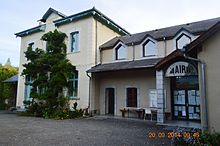
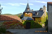
[[File:Antichan-de-Frontignes Mairie.JPG|thumb|The Town Hall and School]] |
|||
[[File:Antichan-de-Frontignes Street.JPG|thumb|A Street in Antichan-de-Frontignes]] |
|||
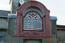
[[File:Antichan-de-Frontignes War Memorial.JPG|thumb|Antichan-de-Frontignes War Memorial]] |
|||
==Sites and monuments== |
|||
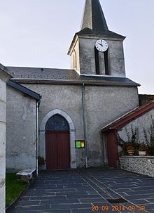
[[File:Antichan-de-Frontignes Church.JPG|thumb|The Church of Notre Dame of the Assumption]] |
|||
*The village is the point of departure for a '''[[hiking trail]]''' which crosses the Col des Ares 4.5 km from the village then continues to the summits of the [[Pic du Gar]] and the Saillant Peak. |
|||
*The '''Church of Notre-Dame of the Assumption''' |
|||
==See also== |
==See also== |
||
[[Communes of the Haute-Garonne department]] |
*[[Communes of the Haute-Garonne department]] |
||
==References== |
|||
{{Haute-Garonne communes}} |
|||
{{Reflist|2}} |
|||
{{DEFAULTSORT:Antichan-De-Frontignes}} |
|||
[[Category:Communes of Haute-Garonne|Antichandefrontignes]] |
|||
==External links== |
|||
*[https://web.archive.org/web/20070311153127/http://www.ign.fr/affiche_rubrique.asp?rbr_id=1087&CommuneId=32101 Antichan-de-Frontignes on the old IGN website] {{in lang|fr}} |
|||
*[http://www.geoportail.gouv.fr/accueil?c=0.6661,42.9742&z=7.92265E-5&l=GEOGRAPHICALGRIDSYSTEMS.MAPS.3D$GEOPORTAIL:OGC:WMTS@aggregate(1)&l=ADMINISTRATIVEUNITS.BOUNDARIES$GEOPORTAIL:OGC:WMTS(1)&permalink=yes Antichan-de-Frontignes on Géoportail], [[Institut géographique national|National Geographic Institute]] (IGN) website {{in lang|fr}} |
|||
*[http://rumsey.geogarage.com/maps/cassinige.html?lat=42.9742&lon=0.6661&zoom=13 ''Antichan-de-Frontignes'' on the 1750 Cassini Map] |
|||
{{Commons category|Antichan-de-Frontignes}} |
|||
{{Haute-Garonne communes}} |
|||
{{authority control}} |
|||
{{HauteGaronne-geo-stub}} |
|||
{{DEFAULTSORT:Antichandefrontignes}} |
|||
[[an:Antishan de Frontinha]] |
|||
[[Category:Communes of Haute-Garonne]] |
|||
[[ca:Antishan de Frontinhan]] |
|||
[[ceb:Antichan-de-Frontignes]] |
|||
[[es:Antichan-de-Frontignes]] |
|||
[[eu:Antichan-de-Frontignes]] |
|||
[[fr:Antichan-de-Frontignes]] |
|||
[[it:Antichan-de-Frontignes]] |
|||
[[la:Antichan-de-Frontignes]] |
|||
[[mg:Antichan-de-Frontignes]] |
|||
[[ms:Antichan-de-Frontignes]] |
|||
[[nl:Antichan-de-Frontignes]] |
|||
[[pl:Antichan-de-Frontignes]] |
|||
[[sr:Антишан де Фронтињ]] |
|||
[[bug:Antichan-de-Frontignes]] |
|||
[[uk:Антішан-де-Фронтінь]] |
|||
[[vi:Antichan-de-Frontignes]] |
|||
[[vo:Antichan-de-Frontignes]] |
|||
[[war:Antichan-de-Frontignes]] |
|||
Revision as of 09:58, 19 January 2024
Antichan-de-Frontignes | |
|---|---|
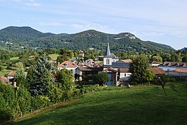 A general view of Antichan-de-Frontignes | |
| Coordinates: 42°58′27″N 0°39′58″E / 42.9742°N 0.6661°E | |
| Country | France |
| Region | Occitania |
| Department | Haute-Garonne |
| Arrondissement | Saint-Gaudens |
| Canton | Bagnères-de-Luchon |
| Intercommunality | Pyrénées Haut Garonnaises |
| Government | |
| • Mayor (2020–2026) | Bernard Dumail[1] |
| Area 1 | 4.27 km2 (1.65 sq mi) |
| Population (2021)[2] | 188 |
| • Density | 44/km2 (110/sq mi) |
| Time zone | UTC+01:00 (CET) |
| • Summer (DST) | UTC+02:00 (CEST) |
| INSEE/Postal code | 31009 /31510 |
| Elevation | 533–1,655 m (1,749–5,430 ft) (avg. 600 m or 2,000 ft) |
| 1 French Land Register data, which excludes lakes, ponds, glaciers > 1 km2 (0.386 sq mi or 247 acres) and river estuaries. | |
Antichan-de-Frontignes (French pronunciation: [ɑ̃tiʃɑ̃ də fʁɔ̃tiɲ]; Occitan: Antishan de Frontinhas) is a commune in the Haute-Garonne department in the Occitanie region of south-western France.
Geography
Antichan-de-Frontignes is located at the foot of the Pyrenees in the Comminges region some 40 km east by south-east of Bagnères-de-Bigorre and 19 km south by south-west of Saint-Gaudens. Access to the commune is by the D618 road which branches from the D331 east of Ore and goes to the village then continues north-east by a roundabout route to Juzet-d'Izaut. There is also a local road going from the D618 north of the village to Saint-Pé-d'Ardet. Most of the commune is heavily forested however there is some farmland near the village.[3]
Neighbouring communes and villages
Administration
List of Successive Mayors[4]
| From | To | Name |
|---|---|---|
| 2001 | 2026 | Bernard Dumail |
Demography
The inhabitants of the commune are known as Antichanais or Antichanaises in French.[5]
|
| ||||||||||||||||||||||||||||||||||||||||||||||||||||||||||||||||||||||||||||||||||||||||||||||||||||||||||||||||||
| Source: EHESS[6] and INSEE[7] | |||||||||||||||||||||||||||||||||||||||||||||||||||||||||||||||||||||||||||||||||||||||||||||||||||||||||||||||||||
Sites and monuments
- The village is the point of departure for a hiking trail which crosses the Col des Ares 4.5 km from the village then continues to the summits of the Pic du Gar and the Saillant Peak.
- The Church of Notre-Dame of the Assumption
See also
References
- ^ "Répertoire national des élus: les maires" (in French). data.gouv.fr, Plateforme ouverte des données publiques françaises. 13 September 2022.
- ^ "Populations légales 2021" (in French). The National Institute of Statistics and Economic Studies. 28 December 2023.
- ^ a b Google Maps
- ^ List of Mayors of France (in French)
- ^ Le nom des habitants du 31 - Haute-Garonne, habitants.fr
- ^ Des villages de Cassini aux communes d'aujourd'hui: Commune data sheet Antichan-de-Frontignes, EHESS (in French).
- ^ Population en historique depuis 1968, INSEE
External links
- Antichan-de-Frontignes on the old IGN website (in French)
- Antichan-de-Frontignes on Géoportail, National Geographic Institute (IGN) website (in French)
- Antichan-de-Frontignes on the 1750 Cassini Map


