


NAVSTAR GLOBAL POSITIONING SYSTEM
NOVELLA on DoD USER EQUIPMENT
LETTER OF FINDINGS
June 30, 1996
FEDSIM Project Number 96061AFD-02
Prepared by:
SCIENCE APPLICATIONS INTERNATIONAL CORPORATION
SPACE AND DEFENSE GROUP
Under Contract to:
FEDERAL SYSTEMS INTEGRATION AND MANAGEMENT CENTER FEDERAL OFFICE SYSTEMS CENTER
Prepared for:
THE JOINT PROGRAM OFFICE
NAVSTAR GLOBAL POSITIONING SYSTEM
(SMC/CZL)
2435 Vela Way, Suite 163
Los Angeles Air Force Base, CA 90245-5500
NOVELLA ON DoD GPS USER EQUIPMENT
Table of Contents
Preface 1
1.0 Executive Summary 2
2.0 Background 2
2.1 Opportunities for Technology Exploitation 2
2.2 Proven System Performance 3
2.3 GPS JPO Direction 4
2.3.1 Mission 4
2.3.2 Responsibilities 4
2.3.2.1 Acquisition 6
2.3.2.2 Joint Service/Allied Representation 7
2.3.2.3 Foreign Military Sales (FMS) 7
2.3.3 Roles 8
3.0 Current Products, Projects and Capabilities 9
3.1 Products/Trends 9
3.1.1 Receivers for Integrations 12
3.1.1.1 3A/MAGR 12
3.1.1.2 3S Receiver 14
3.1.1.3 2-Channel Receiver 14
3.1.1.4 Embedded GPS Inertial Navigation System (EGI) 14
3.1.1.5 GPS VME Receiver Card (GVRC) 14
3.1.2 Portable/Handhelds 15
3.1.2.1 Manpack 15
3.1.2.2 Small Lightweight GPS Receiver 16
3.1.2.3 Precision Lightweight GPS Receiver 16
3.1.3 Security Devices 17
3.1.4 Antenna Systems 17
3.1.4.1 Fixed Reception Pattern Antennas 17
3.1.4.2 Controlled Reception Pattern Antennas 18
3.1.4.3 Antenna Electronics 18
3.1.4.4 Handheld Receiver Antennas 19
3.1.4.5 Antenna Systems Under Development 19
3.1.5 Specialty Receivers 19
3.1.5.1 Special Operations Lightweight GPS Receiver (SOLGR) 19
3.1.5.2 Survey GPS Receiver (SGR) 20
3.1.5.3 Timing GPS Receiver (TGR) 20
3.1.6 GPS Receiver Applications Module 20
3.1.7 Control Display Unit (CDU) 21
3.2 Logistics/Supportability 22
3.2.1 Current Capabilities 22
3.2.2 Integrated Logistics Support Objectives 22
3.2.3 User Equipment Consignment 22
3.3 Test and Evaluation 22
3.3.1 History 22
3.3.2 Test and Evaluation Center of Expertise 23
3.3.3 Test Responsibilities 23
3.3.4 Status 23
3.4 Integration 24
3.4.1 Responsibilities 25
3.4.2 Integration Status 26
3.4.2.1 Air Force 28
3.4.2.2 Navy 28
3.4.2.3 Army 28
3.4.3 Installations 29
3.4.3.1 Aircraft Receiver Configuration Plan 29
3.4.4 Project 2000 29
4.0 Evolving Requirements and Implementation 30
4.1 Performance Areas 32
4.1.1 Security 33
4.1.2 Accuracy 33
4.1.3 Integrity 34
4.1.4 Survivability 35
4.2 Advanced Technology Initiatives 35
4.2.1 Integrity Monitoring 35
4.2.1.1 Receiver Autonomous Integrity Monitor 35
4.2.1.2 GPS Integrity Channel 36
4.2.2 Differential GPS 36
4.2.2.1 Employment Concepts 37
4.2.2.2 DGPS Performance 38
4.2.2.3 Planned Systems 38
5.0 Future Scan 40
5.1 Scenario/Environment 40
5.2 Future JPO Roles 41
5.2.1 Security 41
5.2.2 Influencing Technology Development 41
5.3 Upgrades/Pre Planned Product Improvements (P3I) 42
5.3.1 Receivers 42
5.3.2 Antenna Systems 43
6.0 Conclusion 43
Appendix A Table of Acronyms 45
Appendix B Glossary of Terms 48
Index 54
List of Figures
|
Figure # |
Name |
Page |
|
2-1 |
Civil Use of GPS vs. DoD |
3 |
|
2-2 |
Evolution of GPS JPO Responsibilities |
5 |
|
2-3 |
DoD Versus Commercial GPS Requirements |
6 |
|
2-4 |
Spectrum of GPS Acquisition Support Functions |
9 |
|
3-1 |
GPS User Equipment Technology Evolution |
11 |
|
3-2 |
DoD UE Family Tree |
12 |
|
3-3 |
3A Receiver |
13 |
|
3-4 |
MAGR |
13 |
|
3-5 |
3S Receiver |
14 |
|
3-6 |
GPS VME Receiver Card |
15 |
|
3-7 |
Most Recent Generation of Portable GPS Receivers |
15 |
|
3-8 |
Manpack |
16 |
|
3-9 |
PLGR |
17 |
|
3-10 |
FRPA-4 |
18 |
|
3-11 |
CRPA |
18 |
|
3-12 |
The AE-1 and the AE-4 |
19 |
|
3-13 |
GRAM |
20 |
|
3-14 |
CDU |
21 |
|
3-15 |
Nominal GPS Integration Cycle |
24 |
|
3-16 |
GPS Integrations to Meet Project 2000 (Retrofit only) |
30 |
|
4-1 |
Receiver Autonomous Integrity Monitoring (RAIM) |
36 |
|
4-2 |
Differential GPS |
37 |
|
4-3 |
Relative Navigation Concept |
38 |
List of Tables
|
Table # |
Name |
Page |
|
2-1 |
GPS Force Enhancements Demonstrated during Desert Storm |
4 |
|
2-2 |
User Requirements Forecast |
6 |
|
2-3 |
GPS JPO User Equipment Roles |
8 |
|
3-1 |
Past JPO User Equipment Buys |
10 |
|
3-2 |
Projected JPO User Equipment Buys |
10 |
|
3-3 |
GPS Avionics vs. Host Platform Matrix |
29 |
|
3-4 |
GPS Integrations Overview |
30 |
|
4-1 |
Performance Areas vs. GPS Segments and Augmentations |
32 |
|
4-2 |
DGPS Performance vs. Selected DoD Requirements |
34 |
Preface
The Global Positioning System (GPS) Joint Program Office (JPO) has published a number of documents about GPS over the years; all have addressed the technical aspects of the system. Now that the system is mature and recognized as a world utility, predictable parochial interests and pressures from its broad population of users (from within and without the Department of Defense (DoD)) are influencing policy and programmatic maturation. The time has come to document and explain the programmatic aspects of the DoD User Equipment Acquisition Program, its past, present and forecasted future. The goal is to offer a background and framework for policy and decision makers upon which to base informed decisions pertaining to DoD's GPS User Equipment and its utility to the U.S. and Allied Military Services. Additionally, the JPO intends this Novella to be an informative communication with its current and prospective customers, both within DoD and in the worldwide civil community.
Note:
This document has, by design, a very large and diverse target population of readers. Many may already be familiar with the terms and technologies addressed, many may not. Consequently, this Novella was written to explain the DoD GPS User Equipment Program in as simple a fashion as possible, which is not as succinctly as would be appropriate for those with recent affiliation with GPS. Conversely, there are sections of this document that provide more technical detail and references than some readers may need or appreciate. Efforts were made to begin sections and paragraphs with simple descriptions, making the transition to more detail as necessary. The reader's consideration is solicited. A Table of Contents, Table of Acronyms, Glossary of Terms, and an Index are provided for completeness and assistance to those of varied familiarity with the topics presented.
NOVELLA ON
DoD GPS USER EQUIPMENT
1.0 Executive Summary. GPS is a World Utility. The GPS Joint Program Office, as the system acquisition manager, is the recognized Center of Expertise; one important mission is to satisfy the user equipment (UE) requirements of the DoD and our Allied counterparts. Preserving the force enhancement and military advantage benefits of GPS to the military Services is a primary goal as the JPO plans and implements improvements in its products.
Subsequent to production of the initial suite of GPS receivers (known as "user equipment"), the JPO undertook several initiatives to support expanding requirements for improved performance. Ready availability of commercial sets that met most of the military's requirements allowed the JPO to make use of non-developmental item (NDI) acquisition procedures to satisfy these needs quickly and economically. The timing of the initiative to acquire improved handheld receivers allowed rapid response to Desert Storm requirements, making substantial contributions to the Allied victory, while demonstrating the force enhancement value of GPS. This, in turn, awakened the users to the extraordinary utility of GPS in support of their missions.
Currently, the JPO is aggressively undertaking efforts to forecast future GPS UE requirements, and is taking steps to expediently improve existing and add requisite new UE capabilities to meet evolving military needs. Consideration of civil needs in the system's management and capability improvement planning is also taking place. To support this objective, the Department of Transportation (DOT) has representation at both the Air Force Space Command (AFSPC) and the JPO. Other key efforts focus on increasing the design life of receivers, decreasing life-cycle costs, enhancing security measures, and reducing equipment size and weight while improving performance in an evolving battlefield scenario.
2.0 Background. The Office of the Secretary of Defense (OSD) has recognized the GPS program as both the largest avionics procurement and one of the most successful acquisition programs in the history of DoD.
2.1 Opportunities for Technology Exploitation. GPS has quickly become very popular in the civilian sector -- it provides a quantum leap in accuracy of position, navigation, and time compared to previously available systems. Civil sector use of GPS almost immediately surpassed that of DoD; this occurred while the system was still under development. As the commercial world's understanding of the system and its capabilities increased, new applications arose rapidly, and the civil user community grew exponentially. New ideas and techniques became available as new technology was applied to GPS hardware and software to reduce receiver cost, size, weight, and power usage, while greatly increasing functionality. As improved GPS equipment became available at lower cost, new users and new applications fed the increasing growth rate. Additional new and expanded applications are evolving as this is being written, making it clear that the present and future civil sector market for quantities of GPS equipment are much greater than that of the DoD market. Figure 2-1 provides a notional comparison over time of the numbers of civil versus DoD users of GPS.

Figure 2-1: Civil Use of GPS vs. DoD
Rapidly expanding civilian use has resulted in huge leaps forward in available technology along with an expanding list of features and applications. Civil sector users funded the majority of the Research and Development (R&D) performed on the newest GPS sets. The JPO has been able to use this fact to considerable advantage for DoD, using the NDI process to shorten acquisition schedules, reduce direct costs, transition to the latest technology, and enhance usefulness of receivers procured by including newly developed features.
2.2 Proven System Performance. The availability of GPS to support land-based, aerial and seaborne combat operations in the trackless, featureless desert made a major contribution to the Allied forces' victory in Operation Desert Storm. The utility and force-enhancement qualities of the system were amply demonstrated during that conflict, with documented (and in many cases quantifiable) results in those areas listed in Table 2-1.
|
Improved Position Accuracy |
Accurate Weapon Placement |
|
|
|
|
|
|
|
|
|
|
|
|
|
|
|
Enhanced Systems Performance |
Provided Time Synchronization |
|
|
|
|
|
|
|
|
|
|
|
|
|
|
Table 2-1: GPS Force Enhancements Demonstrated during Desert Storm
2.3 GPS JPO Direction. Congressional and OSD policy declarations designate the GPS JPO as the central DoD agency for the development and procurement of GPS UE. The common underlying rationale is cost savings and security assurance. Specific objectives for concentrating development and acquisition of GPS UE at the GPS JPO have included:
- to procure GPS UE in economical quantities,
- to preclude duplication of GPS UE development efforts and associated costs,
- to benefit from lessons learned on existing GPS UE designs,
- to develop GPS UE systematically to take advantage of emerging technologies,
- to reduce GPS UE life cycle costs,
- to maximize logistics economies through multi-service commonality, and
- to ensure GPS security requirements are satisfied.
Section 3.0 provides information on current products, capabilities, and initiatives within the JPO to ensure that the above objectives are realized.
2.3.1 Mission. PMD 4075 (32) Program Management Directive for the NAVSTAR Global Positioning System states the mission of the UE Segment is to "[d]evelop, acquire, sustain, and procure GPS UE to satisfy validated and funded multi-Service requirements."
2.3.2 Responsibilities. At its inception, the GPS JPO was seen as a normal Systems Program Office (SPO) which would be responsible for taking this major system through each of its developmental and production milestones. UE would consist of a family of receivers with as much commonality as possible, to support integrations into aircraft and aboard ships, along with a modest number of sets for portable use. The system would undergo the normal transition (Program Management Responsibility Transfer -- PMRT) for long-range support. Then the JPO would be reduced in size to a small office responsible for Engineering Change Proposals (ECPs) and the like. With the implementation of Integrated Weapon Systems Management (IWSM), PMRT was eliminated and the GPS JPO became responsible for "cradle-to-grave" management of the system; thus the organizational elements supporting sustainment of UE (located at Robins Air Force Base (AFB)) and the Control Segment (located at Peterson AFB) were added to the JPO line organization.
Over time, the demand for GPS sets and the applications within DoD have grown at a surprising rate. Further, the unexpected popularity of GPS within the civil sector has provided the means to rapidly satisfy the military user's demands for more features and reduced size and cost via the NDI process. Given the requirement and the funding, an NDI procurement can begin deliveries from within a few weeks (as was done with the Small Lightweight GPS Receiver (SLGR) for Desert Storm) up to two to three years depending on the urgency of the need and the range of minor modifications that are required of the commercial item. This is a major improvement over the standard acquisition process typically requiring ten to fifteen years, and one which is not commonly afforded most other military equipment procurement programs because of the uniqueness of the item required. (That is, the item is generally not available in the commercial marketplace.) The total quantity of GPS UE initially expected to be required is now recognized as less than one-fifth of today's military needs (in spite of reduced force structure).
As GPS becomes increasingly an integral part of almost all electronic systems (providing precise location/navigation and time/timing), future requirements are expected to exceed 200,000 military GPS users. GPS receivers will become smaller and smaller. Many receivers will be fully integrated into some larger unit, all but invisible to the user. Thus the role of the GPS JPO has evolved gradually over the past 20-plus years, with today's activity equally as demanding as it was during the peak years leading to a production decision. The JPO's need for a competent and fully capable staff remains very much the same. It is expected that this need will continue for some time to come, with an eventual reduction in staff size becoming appropriate when GPS UE transitions to receiver software embedded into larger systems with a small antenna. Figure 2-2 depicts some of the more visible functions for which the JPO is responsible today.

Figure 2-2: Evolution of GPS JPO Responsibilities
2.3.2.1 Acquisition. Due to significant use within the civil sector and its growing dependence on GPS, the new developments resulting from the rapidly growing and innovative non-DoD market have allowed UE acquisitions to exploit advancing technology with minimal development costs. Contrary to the relationship normally encountered between military and commercial item requirements, there is considerable commonality between military GPS requirements and civil sector GPS requirements as shown in the Venn diagram (Figure 2-3) below.

Figure 2-3: DoD Versus Commercial GPS Requirements
One of the significant differences between DoD GPS receivers and their civil-use counterparts is their access to the Precise Positioning Service (PPS) resulting in accuracies specified at £ 16 meters in three dimensions (Spherical Error of Probability - SEP); this is known as Selective Availability (SA). GPS receivers also have the ability to receive and to decode encrypted signals meant exclusively for military use. Civil users are only guaranteed 100 meters accuracy with the Standard Positioning Service (SPS). Encryption of the satellite signals for authorized users also affords protection against signal interference (known as Anti-Jam (A-J)) and emulation with intent to induce errors (known as Anti-Spoofing (A-S)).
The majority of improvements desired in GPS UE are common to both the DoD and the civil sector. Thus the commercial world's efforts to satisfy the constantly growing demand for "better, faster, cheaper" fits very nicely with DoD's needs for improved UE. Table 2-2, shown below, lists the generic improvements being sought by GPS users. Those listed at the bottom (shaded background) are specific to DoD and are generally subject to the need for a greater investment by DoD if future requirements are to be met.
|
|
|
|
|
|
|
|
|
|
|
|
|
|
|
|
|
|
|
|
*Also has civil interest, but is DoD controlled
Table 2-2: User Requirements Forecast
The DoD realizes a significant benefit from investments made by the civil sector to produce UE which is not only better than the old item, but also has new capabilities as well; further, the combination of competition and maturing technology operates to drive down the cost of GPS UE. Thus, the JPO has been able to use NDI procedures for all recent UE acquisition projects, reducing the time required to reach production and driving the cost much lower than originally anticipated. This process also provides another useful feature, as in some cases it's cheaper and faster to simply buy a new and improved product rather than modify existing equipment.
2.3.2.2 Joint Service/Allied Representation. The JPO has consistently maintained working relationships with all GPS military users in all Services as well as most of the North American Treaty Organization (NATO) member nations and Australia; many have been represented on the JPO staff. Through its close working relationships with each of the Services, the JPO has managed to ensure commonality and standardization across 14,000-plus aircraft, all ground vehicles, ships and submarines, and more than 50,000 handheld receivers for United States Forces and Foreign Military Sales (FMS). By accommodating all the Services' varying requirements, as well as those from our Allies, significant economies of scale were achieved.

Congress has directed DoD to configure all aircraft with GPS by the end of Fiscal Year (FY) 2000 (see Section 3.4.4); this mandate would be difficult to achieve without the JPO's cross-Service coordinated development, procurement, test and evaluation, and integration support.
2.3.2.3 Foreign Military Sales (FMS). Another JPO task is to incorporate (to the extent feasible) requirements of allied nations' military forces in UE development; this is affected for each new procurement or by ECP when necessary. The GPS JPO provides GPS acquisition services for our Allies. To perform these services effectively, the FMS Integrated Product Team (IPT) was formed. Requests for UE for FMS must be reviewed with an understanding of UE and how it will be implemented and used by the FMS customer. Having local access to various functional areas and their expertise within the JPO enables requests for FMS to be responded to appropriately and within a short period of time.
Following the special procedures required for processing FMS equipment orders (cases), requirements are consolidated from various user requests in order to obtain price breaks from larger quantity orders on established contracts with the various producers of GPS equipment. The goal is to provide FMS customers with expeditious one-stop shopping that can include either contracted or organic logistics support. FMS procurements can take advantage of the GPS Depots offering fast and economical turn-around for repair items with continuous repair capability. If necessary, hardware and software upgrades can be implemented organically.
The JPO FMS IPT can also assist in arranging training for FMS users through the various US Military Services and vendors that provide training support. In its capacity as the manager for the system's security (access/control of keys and algorithms necessary for the increased accuracy and other non-military capabilities), the JPO ensures GPS security procedures are appropriately complied with in keeping with the customer nation's authorized access to GPS security functions.
2.3.3 Roles. In 1991, UE passed from Limited Rate Initial Production (LRIP) into Full Rate Production (FRP). Commensurate with this milestone, the JPO developed the UE road map. This plan addressed the changing acquisition environment in terms of market forces, demand for products and services, customer base, declining budgets, rapidly advancing technology, and evolving requirements. One of the principle outcomes of the road map development, which was fully coordinated and endorsed throughout DoD and by OSD, was a codification of new roles the JPO was being called upon to fulfill. Table 2-3 depicts these roles and related responsibilities for GPS UE acquisition; it also represents the services available to the JPO's current and prospective customers; the other systems program managers that plan to incorporate or interface with GPS.
|
Roles |
Responsibilities |
|
Central Procurement Agency GPS Common User Equipment |
|
|
Technology Manager GPS-Related Technologies (Exclusively DoD and GPS Common Embedded UE) |
|
|
Technology Consultant All DoD Non-JPO UE Developments & Procurements (Unique) |
|
|
Development Monitor Technologies with Potential Application to GPS |
|
Table 2-3: GPS JPO User Equipment Roles
In the early 1990s, it was noted that a strong interest to incorporate GPS from the non-avionics systems managers within the DoD was emerging. This new class of customers required different products and support from the JPO than is normally expected from a more traditional weapon system acquisition manager. Also, there was the problem of systems acquisition managers developing/procuring GPS UE without JPO involvement despite OSD policy and direction to the contrary. Proliferation of non-standard GPS hardware, software, and integration schemes was a growing concern for reasons of security, interoperability, and economics. Aggressive marketing by the GPS industry exacerbated this situation.
Figure 2-4 illustrates the spectrum of GPS acquisition support functions identified by the JPO as requisite to reducing the proliferation trend (expected to get worse without JPO involvement and support).

Figure 2-4: Spectrum of GPS Acquisition Support Functions
Providing support that will reduce program risks (cost, schedule, technical) is recognized as an important incentive for non-avionics programs to coordinate with the JPO on their GPS initiatives. To this end, the services and resources (referenced in Table 2-3) are offered by the JPO; support products include a "shopping list" of easily integratable common UE and devices, specifications, Interface Control Documents (ICDs), guidelines, lessons-learned, functional test and certification, and technical/security compliance expertise.
3.0 Current Products, Projects and Capabilities
3.1 Products/Trends. The initial concept was for a family of GPS UE which shared some common hardware and software elements. The progress of technology (faster, smaller, lighter, cheaper), development of new techniques and applications for GPS, the Gulf War, and rapid expansion of civil use of the system have resulted in a strong demand for receivers.
Total past and projected JPO User Equipment buys across the Services and Foreign Military Sales exceeds 164,000 receivers. This total is broken out by customer and year in Tables 3-1 and 3-2.

Table 3-1: Past JPO User Equipment Buys

Table 3-2: Projected JPO User Equipment Buys
UE technology evolution has rapidly progressed from relatively large, heavy, and power-demanding "boxes" with limited capabilities to smaller, more capable devices (handheld-size units and embedded cards/modules), and is expected to ultimately transition to embedded software (plus antenna hardware for signal input) as technology advances in electronic miniaturization mature. This evolution is captured graphically in Figure 3-1.

Figure 3-1: GPS User Equipment Technology Evolution
Initial JPO developments and procurements were exclusively Line Replaceable Units (LRUs), or "boxes," which included the 3A receiver for high-dynamic aircraft applications, the 3S receiver for shipboard applications, and the Manpack for low-dynamic portable applications. These were followed by the smaller and lighter Miniaturized Airborne GPS Receivers (MAGR) for high- and medium-dynamic aircraft, and the Precision Lightweight GPS Receiver (PLGR) for hand-held portability as well as installation in selected platforms. Antenna systems in LRU configurations included the Fixed Reception Pattern Antenna (FRPA), the larger/heavier Controlled Reception Pattern Antenna (CRPA), and the Antenna AE-1/AE-4 (Antenna Electronics) devices. The GPS Receiver Applications Module (GRAM) and Selective-Availability/Anti-Spoof Module (SAASM) initiatives are the next rungs on this evolutionary ladder. Greater detail on these and other JPO programs is provided in the following paragraphs.
Figure 3-2 illustrates the DoD UE "Family Tree." It provides an overview of the progressions and transitions which each of the several categories of UE have undergone and are expected to undergo in the foreseeable future. It also illustrates the gradual transition from the use of traditional developmental procurement methods to the use of the current procedure which emphasizes use of NDI acquisitions. The acronyms and nomenclature associated with these products are explained in the subsequent sections.

Figure 3-2: DoD UE Family Tree
3.1.1 Receivers for Integrations.
3.1.1.1 3A/MAGR. Most of the current DoD aircraft is scheduled for integration with GPS JPO-procured 3A and MAGR. These receivers are fully mil-qualified and have undergone extensive developmental and qualification testing.
Although the 3A receiver (represented in Figure 3-3) was developed in 1985, it continues to perform well in the field; the 3A receiver has only received a modest upgrade and is considered to be "older technology." It has five channels to receive and process satellites; the larger the number of correlators, the faster the receiver computes the first fix and updates position. The Time to First Fix (TTFF) is important to the speed or dynamics of the host platform. The three primary functional shortcomings of the 3A receiver are that: 1) it is not field reprogrammable (in other words it must be returned to a depot for upgrade), 2) it does not implement an enhanced anti-spoofing function (recognition and avoidance of deception - intentional or unintentional signal interference), and 3) it is large, heavy and contains many outdated/obsolete components. The depot at Warner Robins-Air Logistics Command (ALC) provides sustainment support for the 3A receivers, and will continue in that role for the foreseeable future.

Figure 3-3: 3A Receiver
The MAGR, pictured in Figure 3-4, was developed in 1990 as the GPS JPO's answer to most of the 3A's shortfalls (anti-spoofing improvements are awaiting ECP). The MAGR is less expensive (2/3 cost of the 3A), smaller (1/3 the size/weight of the 3A), more reliable, and field reprogrammable. This receiver has the same number of channels as the 3A (5 channels). An NDI procurement approach took advantage of a commercially-developed product (Rockwell-Collins 3M receiver) and advancing microelectronics technology.

Figure 3-4: MAGR
Both the 3A and MAGR are being considered for upgrade/enhancement programs (discussed in Section 5.3); form, fit, and platform interface of both receivers would be retained to preclude impact to existing integrations.
3.1.1.2 3S Receiver. The 3S receiver, represented in Figure 3-5, is significantly larger than the 3A. However, it is very similar functionally to the 3A. It has five channels and contains features that enhance its ability to support shipboard requirements for Navy surface ships and submarines, as well as a small number of Army vessels.

Figure 3-5: 3S Receiver
3.1.1.3 2-Channel Receiver. The 2-Channel receiver was part of the initial suite of GPS UE which used several circuit cards in common with the 3A, but was housed in a smaller, lighter weight box. Use of two channels (compared with five in the 3A) suited its intended application as a medium dynamics receiver for integration into light aircraft and helicopters. Only a small number were procured, as newer receivers quickly became available that outperformed the 2-Channel in every desirable category. These receivers are still being used and supported. However, there are no plans to upgrade or reprocure them.
3.1.1.4 Embedded GPS Inertial Navigation System (EGI). The EGI is a modern navigation device which combines a GPS receiver card with an inertial navigation system card in an integrated, single unit of modest size and weight. This receiver is being procured by the Air Force's Aeronautical Systems Center (ASC), with the GPS JPO acting as GPS technology consultant and managing the Qualification Test and Evaluation (QT&E) program. The EGI is undergoing QT&E at this time and is being integrated into aircraft (including helicopters) where there are weight/space constraints or inertial navigation systems (INSs) are being replaced and economics is a factor.
3.1.1.5 GPS Versa Modula Eurocard (VME) Receiver Card (GVRC). The GVRC, illustrated in Figure 3-6, is a card assembly which will replace the GPS 3S receiver as part of the Navy's Navigation Sensor System Interface (NAVSSI) for shipboard and submarine GPS installations. The GVRC will provide replacement GPS capability in a single, comparatively low cost card that will capitalize on commercial GPS technology advancements using a Versa Modula Eurocard (VME) form factor. (Note: The form factor relates to the shape of the card and how it communicates with its host installation - a "rack" or "bus"; VME is a very common form factor in both commercial and DoD computer systems.) The GVRC is being procured by the JPO as an NDI acquisition.

Figure 3-6: GPS VME Receiver Card
3.1.2 Portable/Handhelds. The DoD product line for portable GPS receivers began with the Manpack. The SLGR and PLGR (Figure 3-7) followed.

Figure 3-7: Most Recent Generation of Portable GPS Receivers
3.1.2.1 Manpack. Figure 3-8 is a representation of the Manpack. This one-channel receiver was also part of the initial suite of GPS UE, and shared some circuit cards with the 3A and 2-Channel receivers. It was intended to support portable applications and provided excellent accuracy, but was large (about the size of an ammunition box), heavy (17 pounds), and had a very limited battery life. Until handheld-sized receivers were commercially developed, the Manpack was a desirable complement to ground and special operations forces. As with the 2-Channel receiver, only a small number were procured up until the time that the handheld receivers became available.

Figure 3-8: Manpack
3.1.2.2 Small Lightweight GPS Receiver. Six thousand SLGRs were procured during the early 1990s to satisfy immediate and urgent demands for a miniaturized version of the Manpack. The sets procured using NDI procedures were commercially available 1-, 2-, 3-, and 5-channel receivers which operated using only the Standard Positioning Service signal (they cannot decode the Precise Positioning Service signal which provides enhanced protection and accuracy for authorized users). Their small size, limited battery drain, and low cost (at the expense of PPS-accuracy) were highly desirable to satisfy the urgent needs of mobile military units. Selective Availability was turned off for this operation. Their availability for use in Desert Storm made a major contribution to US/UN Forces' operations and proved the value of GPS in supporting modern warfare.
3.1.2.3 Precision Lightweight GPS Receiver. The PLGR was acquired to fill a need for a miniaturized handheld receiver equivalent in size to the SLGR, but capable of receiving the more accurate PPS signal in addition to incorporating other required features. The PLGR is illustrated in Figure 3-9. It was procured in 1993 using NDI procedures, and its production continues. Advancing GPS technology combined with competition to yield an unexpectedly low cost that resulted in a high demand for this very capable receiver. In addition to extensive handheld and ground-mobile use, the PLGR is being used for other medium dynamics applications.
The Enhanced PLGR (sometimes referred to as EPLGR) is also being procured with the performance objective of lower power usage; longer battery life is estimated to save $25M in battery procurements. It incorporates Differential GPS (DGPS -- explained in Section 4.2.2) and a number of changes that include other data interfaces and forty-three new user interfaces and display type functions.

Figure 3-9: PLGR
3.1.3 Security Devices. Security devices are incorporated into DoD receivers to allow access to the PPS and SA. They perform the basic cryptographic functions for GPS UE; to include the generation of Y-Code and taking out the effects of Selective Availability. The GPS JPO manages access and security design approval for all security devices. The family of GPS security devices includes the Auxiliary Output Chip (AOC), Precise Positioning Service Security Module (PPS-SM), Selective Availability Anti-Spoofing Module, and SAASM Code Block (SCB).
3.1.4 Antenna Systems
3.1.4.1 Fixed Reception Pattern Antennas. FRPAs have been developed for aircraft and shipboard use with GPS receivers. These comprise a single element, omni-directional antenna to receive GPS satellite signals from about five to ten degrees above the horizon and up. The FRPA-3 is used for aircraft applications, the FRPA-GP (a FRPA-3 mounted on a ground plane) is used for shipboard applications, and the FRPA-4 (Figure 3-10) is used with the Manpack.

Figure 3-10: FRPA-4
3.1.4.2 Controlled Reception Pattern Antenna. The CRPA-2 has been developed for aircraft use where there is a requirement to provide Anti-Jamming protection. This is a multi-element antenna, which when used with the AE-1/AE-1A, has the capability to form nulls in the antenna reception pattern. This reduces the effectiveness of jamming signals. A CRPA is shown in Figure 3-11 below.

Figure 3-11: CRPA
3.1.4.3 Antenna Electronics. AEs are used for three basic purposes: to amplify the incoming GPS signal to support longer cable runs to the GPS receiver; to convert the incoming GPS signal to the required Intermediate Frequency (IF); and to process adaptively the signal received from a CRPA to reduce the effectiveness of any received jamming signals (AE-1/AE-1A only). Current models are the AE-1/AE-1A, which operates with the CRPA-2, and the AE-4, which is used with the FRPA-3 and FRPA-GP. The AE-1 and the AE-4 are shown in Figure 3-12. The AE-1A will have the same form-factor and look similar to the AE-1.


Figure 3-12: The AE-1 and the AE-4
3.1.4.4 Handheld Receiver Antennas. Handheld GPS receivers use integral fixed reception pattern antennas. Some handheld sets are equipped with an antenna which can be rotated to allow optimal reception, allowing variation in receiver orientation. Others have a built-in antenna which requires that the handheld receiver be properly positioned for optimal signal reception. All handhelds can be used with a remote antenna for vehicular installations.
3.1.4.5 Antenna Systems Under Development. An acquisition is ongoing to provide a modernized version of the AE-1/CRPA-2, entitled the GPS Antenna System (GAS-1). A future acquisition will procure the AE/CRPA-F. This antenna system will incorporate state-of-the-art electronics and signal processing techniques to considerably improve the A-J capability of this type of system.
3.1.5 Specialty Receivers
3.1.5.1 Special Operations Lightweight GPS Receiver (SOLGR). The SOLGR is a self-contained, integrally waterproof, single frequency, PPS capable, hand-held GPS receiver with a revised display, improved battery life and improved software to enable fast/unprotected Time-to-First-Fix and Time-to-Second-Fix (TTSF) performance. This is important for conservation of battery life and reduction of personnel exposure time while attempting to determine one's position without signal masking from trees/buildings/terrain. The SOLGR allows the user to create sub-modes of operation, tailor the sequence of navigation screen displays associated with each sub-mode, and define a sub-mode specific default. Additionally, the SOLGR allows marked point and history file entries, auto leg advance on routes, reversing of routes, and select or deselect of specific satellites.
Contract efforts for the SOLGR are underway. Limited rate initial production has been initiated. Follow-on Operational Test and Evaluation (FOT&E) is scheduled for FY-97.
3.1.5.2 Survey GPS Receiver (SGR). The SGR will provide very precise location of roving SGRs relative to a base (reference) station, using transmitted data for real-time results, or through post-processing techniques. Commercial development efforts have resulted in hardware and software procedures which provide centimeter-level accuracy for baselines of moderate length. The SGR procurement initiative, if sponsored by the Army, will require modification of commercial receivers to incorporate a full P(Y)-Code (Precise Positioning Service tracking capability. The Army is assessing a similar system being procured by the Marine Corps to determine if the U.S. Marine Corps (USMC) receiver can meet Army requirements. The SGR is discussed here as a potential procurement to provide continuity to this document.
3.1.5.3 Timing GPS Receiver (TGR). The TGR specification was for a receiver that would provide a very precise time and timing signal needed to support other systems. An initial NDI procurement resulted in a set which failed to meet user requirements for certification for operational testing; an alternate receiver (SPS only) has subsequently been evaluated as an interim solution to satisfy the user's (Defense Information Systems Agency - DISA) needs. The TGR is discussed here for historical purposes only.
3.1.6 GPS Receiver Applications Module. The GRAM (Figure 3-13) represents a different approach to supporting future needs for a state-of-the-art, highly capable PPS GPS "engine" (a commercial term meaning full GPS processing capability in a small package). The JPO has jointly developed with industry a standard to be used by manufacturers who plan to incorporate GPS into any future military system (includes aircraft, shipboard, ground-based, or munitions equipment applications). JPO certification of compliance with the core standards will be required prior to incorporation of a GRAM into any DoD system. GRAM configurations will use an Open Systems Architecture (OSA) approach which allows system components to be added, replaced or eliminated without redesigning the entire system. GRAM will incorporate SAASM when this security device becomes available and approved.

Figure 3-13: GRAM
GRAMs are to be considered members of the family of common DoD UE not requiring OSD authorization for procurement and use. This will streamline the acquisition process for a DoD Systems Program Office to embed or implement GPS into their systems. The GRAM standard was developed jointly with industry and complies with the DoD initiative to use industry standards.
The goals of the GRAM program are to: a) ensure security, interoperability, and interchangability, b) maintain a number of competitive industry sources for PPS GPS modules for cost reasons, c) reduce proliferation of non-standard interfaces, definitions, functions and performance metrics, d) provide technical definitions that form basis of a JPO receiver card certification, and e) provide a technically expedient and cost effective host for future capability upgrades (discussed in Section 5.3).
The GRAM Standard provides form, interface, and performance requirements, a set of baseline functions, and optional additional functions which can be specified if required by the system. It provides a precise common set of GPS semantics and definitions. Functions are segregated as "minimum and optional additional." At least three types of cards are specified in terms of form-factor: "Modified Standard Electronic Module (MOD SEM), VME, and Weapon." Minimum environmental requirements, mechanical and electrical characteristics, and data messages are included. Additionally, the GRAM Standard defines certification test requirements and provides guidelines for embedding GRAMs in host systems.
3.1.7 Control Display Unit (CDU). The JPO has procured Standard Control Display Units (Std CDU) for use with Navy shipboard receivers and a few aircraft types. These units are for displaying GPS data to the user, but do not provide any computational function. Also, they do not interface with any other avionics equipment besides the GPS receiver. Figure 3-14 displays a CDU.

Figure 3-14: CDU
The Navy has procured, independent of the other Services, the Control Display Navigation Unit (CDNU) for use on various aircraft. The CDNU not only serves as a display of GPS data, but also as a multipurpose display of other sensor information. The CDNU is a controller for GPS and other navigation equipment, as well as communication radio equipment. Additionally, the CDNU includes processing capability to drive aircraft flight instruments based on navigation sensor data, and provides area navigation computations.
3.2 Logistics/Supportability
3.2.1 Current Capabilities. UE sustainment is critical in supporting the GPS user community. Currently three depots (Robins AFB, Tobyhanna Army Depot, and North Island Navy Depot) are providing sustainment to the existing standard baseline of equipment which is used in the field. The current depot level of support provides a continuing process for organic repair capability. It also affords an avenue for the standardization of all GPS equipment, and ensures the configuration of UE equipment remains consistent with security requirements and future upgrades. Other approved GPS equipment is maintained by contractor logistics support which is postured for the same level of responsiveness on security and expected modifications.
3.2.2 Integrated Logistics Support Objectives. Reduced life cycle cost is the primary logistics support objective of the GPS JPO and its Logistics Support Organization at the Air Logistics Center at Warner-Robins AFB. Centralization of tri-Service GPS procurements allows the opportunity to cohesively manage the configuration control and security aspects of UE.
3.2.3 User Equipment Consignment. Since 1991, the GPS JPO has been transferring management of full-rate UE production contracts to its logistics support group (CZW) at Warner-Robins, Georgia. Currently in consideration is the further consignment (transition) of the GPS UE procurement functions to this Air Logistics Center; this means that new procurement contracts for UE and associated equipment would be prepared, awarded, and managed by CZW. The consignment process is anticipated to be a two year phased approach, commencing early in FY 97 and finishing by FY 99. Under IWSM, the GPS Program Director retains responsibility for the entire system from cradle to grave; the decision to transfer the GPS (Program Element) and Designated Acquisition Commander (DAC) authority are not part of this plan.
3.3 Test and Evaluation
3.3.1 History. UE Test and Evaluation (T&E) has adapted to changes in the nature of UE acquisition that have occurred since the first GPS UE was developed and fielded. Early testing was largely developmental in nature, supporting the first GPS user sets, such as the Manpack for land users and 3A and 3S receivers for airborne and shipboard applications. Testing requirements resulted in an initial build-up of extensive laboratory and field test capabilities. Over the last decade the JPO has developed Memoranda of Understanding with test agencies from all Services to be cost effective and reduce redundancy. T&E personnel are well trained and experienced in the idiosyncrasies of UE testing (the military aspects of which are not well understood anywhere else). In recent years, the JPO's T&E capability has adjusted to allow it to effectively support NDI acquisitions. The resulting T&E capability is an asset which ensures that military GPS UE is capable of performing as required and provides all users enhanced operations in peacetime and in combat on a modern battlefield.
3.3.2 Test and Evaluation Center of Expertise. The JPO acts as a central resource for the coordination of GPS T&E. Members of the DoD test community supporting the JPO include the 46th Test Group Holloman AFB, NM; NRaD, Warminster PA; USAWSMR-EPG, Ft Huachuca, AZ; NRL, Washington DC; NAWC-AD, Patuxent River, MD; NISE-West, San Diego, CA; and USACECOM, Ft Monmouth, NJ. The primary goal of the T&E Center of Expertise (COE) is to establish and maintain a GPS test capability in order to support test requirements of all GPS JPO UE acquisition and test programs, and to provide assistance to other DoD customers with their GPS test requirements. Over the past ten years the JPO has worked closely with this same team in the development of unique GPS testing capabilities. Centralized coordination of GPS UE testing has avoided a proliferation of test capabilities and the dilution of testing experience.
3.3.3 Test Responsibilities. The JPO T&E Division supports three levels of testing: 1) JPO-sponsored UE acquisitions, 2) UE acquisitions or test programs sponsored by DoD agencies other than the JPO, 3) and non-DoD test programs requiring assistance or consultation. The T&E Division responsibilities involve: (a) membership in a program IPT to coordinate and advise an acquisition Program Manager in the area of test; (b) development and/or approval of all test planning documents; (c) selection and coordination with required test agencies; (d) preparation of test cost estimation and schedules; (e) monitoring of all test conduct, data capture, reduction, and analysis; (f) assistance in resolution of observed deficiencies; and (g) consolidation of test reports and briefings into one JPO package. JPO T&E in any military program which includes GPS is necessary to minimize program risk and insure that full effectiveness of GPS is realized and that battlefield vulnerabilities are understood and protected against. JPO T&E ensures that requirements as defined in the Operational Requirements Document (ORD) and any other directed studies and threats defined in the System Threat Analysis Report (STAR) are evaluated during the acquisition phase.
3.3.4 Status. The JPO's T&E Division currently advises in several non-JPO acquisitions and manages the T&E of all ongoing JPO acquisitions, the ECPs to existing fielded GPS UE, and one ASC acquisition. In response to inquiries from military users, as well as USAF Scientific Advisory Board and Defense Science Board recommendations on GPS vulnerabilities, it is supporting several characterizations (a test term for defining how the equipment operates) of fielded UE to determine its effectiveness in an electronic warfare (EW) environment. This testing identifies EW vulnerabilities, proposes hardware and software solutions for existing equipment, and supports the development of new capabilities for future UE. As part of this vulnerability characterization, the JPO has learned a great deal about techniques which could adversely affect both civil and military receivers in a hostile EW environment, in addition to understanding the effects of interference from radar and communication transmitters. These techniques provide the foundation for systems which may be employed in the future to affect the use of GPS by non-US/Allied forces on the battlefield. In this regard, T&E is working with operational forces to plan for application of EW lessons-learned to future exercise scenarios.
3.4 Integration. Integration is the incorporation of one system into (or with) another system(s) in a fashion that they operate together. Ensuring the intended performance of each system both independently and in combination without negatively affecting one another is the design and test objective.
GPS is the largest avionics procurement and installation program in the history of DoD. When completed, GPS will have been integrated and installed in over 18,000 aircraft (over 100 different Type/Model/Series) plus a majority of other weapon systems (435 ships, 35,000 vehicles, numerous weapons). Integrating GPS into aircraft systems, whether as a modification to an existing integration scheme or as a part of new system, is a technically challenging, time consuming and costly effort. Figure 3-15 illustrates the nominal time involved in incorporating any major changes to an aircraft systems integration.

Figure 3-15: Nominal GPS Integration Cycle
The first step in the process involves planning; determination of what the test objectives are and how they are to be conducted. Schedules and costs are forecasted. In addition, the requisite test resources, facilities, and equipment are identified. All is documented in Test Plans and Memoranda of Agreement (MOAs). MOAs are necessary to define responsibilities when a number of agencies/laboratories are involved, as is the case for the GPS UE program working with many aircraft systems managers across all the U.S. and Allied Services.
The UE to be tested must be provided by the manufacturer either as part of the procurement process (e.g., a bid-sample for evaluation preliminary to a contract award) or after contract award. They can be early production models or mature equipment. Synchronization of UE deliveries with the planned test schedules is important to preclude holding up expensive test operations or total platform development programs; this can have numerous costly contractual implications to the host aircraft system.
The integration study, design, and test process is iterative; many cycles may be involved until the system performance objectives are achieved and "safe for flight" is certified. Following this is the actual flight testing of the system. This ensures that the performance in all aspects of the system's operational environment is adequately evaluated. It can take from 2.5 to 7 years to get to the actual modification of fleet aircraft and installation of GPS.
Adding to these challenges is the Congressional direction to have GPS installed on all DoD aircraft by the next century (Project 2000). This section will 1) detail the integration and installation responsibilities of the JPO and supporting agencies, 2) provide a status of DoD integrations by Service, and 3) review the installation schedule being implemented to comply with the Project 2000 mandate.
3.4.1 Responsibilities. JPO integration support responsibilities are detailed in the GPS Program Management Directive (PMD). In general, the GPS UE integration branch, SMC/CZUI, provides technical and programmatic support to over thirty United States Air Force (USAF) GPS integration programs. The 46th Test Group Avionics Integration Element at Holloman AFB, NM augments the JPO with expertise in GPS/Inertial Navigation System (INS) integration schemes, avionics architectures, and future requirements. Additionally, CZUI is staffed with Army and Navy representatives who provide technical support to their respective Service's GPS integration programs. Support is also provided to Foreign Military Sales programs such as the F-16 C/D Mid-Life Upgrade and the NATO E-3 Airborne Warning and Control System (AWACS) programs.
CZUI (along with the previously mentioned organizations) performs the following specific responsibilities:
a. Develop and update the USAF GPS Integration Guide (GIG), the Air Force's primary guidance on how to implement GPS for navigation in the National Airspace. This document correlates Federal Aviation Administration (FAA), Radio Technical Commission for Aeronautics (RTCA) Inc., and technical information to assist USAF GPS integrators in meeting the future airspace requirements contained in the Joint Chiefs of Staff (JCS) Master Navigation Plan.
b. Convene a "Compliance Board" to review aircraft GPS integrations with respect to the USAF GIG and operational requirements. The Compliance Board includes members from SMC/CZUI (Chair), the Air Force Flight Standards Agency, the 46th Test Group, and Major Commands (MAJCOMs). The board provides MAJCOMs with a written report on the suitability of the proposed GPS avionics design to meet operational requirements.
c. Maintain the "GPS Project 2000" plan, the funding and schedule requirements to integrate all USAF aircraft with GPS by the end of Fiscal Year 2000 per Congressional directive. This product is used by the Air Staff to identify funding "disconnects" and to re-direct excess funds.
d. Prepare GPS integration studies for selected aircraft.
e. Act as the single focal point for all DoD GPS UE quantity requirements. In support of this effort, CZUI compiles and maintains a database that tracks procurement, delivery and installation data for all Army, Navy, Air Force and FMS GPS programs.
f. Conduct GPS cost trade studies (e.g., a cost/performance/ schedule trade study in support of the AMC's initiative to procure commercial/NDI GPS UE for the C-141, C-5 and KC-135).
In addition to the direct integration support provided by the JPO to the host platform managers, the JPO acts as the single interface to the Air Force Air Staff for each aircraft System Program Office on integration issues.
While maintaining technical and programmatic representation within CZUI for assisting in the above functions, the Navy manages the details of their integrations primarily through the Navy GPS Program Office (PMW/PMA-187) at the Space and Naval Warfare Systems Command (SPAWAR) in Washington D.C. They work directly with the Naval Air Systems Command (NAVAIR) aircraft platform managers.
3.4.2 Integration Status. Most USAF aircraft GPS integration studies are now complete. To date, the JPO and the 46th Test Group have completed GPS integration studies for the C-12, C-20, C-21, C-22, C-26, C-27, T-1, T-43, E-9, TH-53, EC-18, and H-1. Additional studies are planned for the F-16 C/D Block 30 and the F-15A-D. Both of these aircraft are expected to integrate the Embedded GPS/INS unit. Most USAF GPS integration programs are in the design and test phase. Of these, all Air Combat Command (ACC) assets (F-15E, B-1, B-2, E-3, etc.) are scheduled to integrate common/standard GPS UE (RCVR 3A, MAGR, or EGI). Also, studies for Civil Reserve Air Fleet (CRAF) remain to be completed.
Aircraft managed by the Contractor Logistics Support Division (KC-10, C-9, C-12, etc.) at Oklahoma City Air Logistics Center (OC-ALC) require Technical Standard Order (TSO) compliant GPS UE to meet unique FAA certification requirements. Current common/standard military GPS UE do not meet these requirements. In this role, the GPS JPO has supported an OC-ALC initiative to procure commercially available PPS-capable receivers (a Multi-function Control Display Unit with an embedded GPS receiver card). Per agreement with Air Staff and the Office of the Assistant Secretary of Defense, Command, Control, and Intelligence (OASD/C3I), the GPS receiver card procured will be compatible for future retrofit with the GRAM and SAASM. The KC-10 program, the lead Contractor Logistics Support (CLS) GPS integration effort, has already procured some of this equipment for trial installation and test purposes. If this equipment performs satisfactorily, it is expected to become the common equipment for the remainder of the CLS aircraft.
Air Mobility Command (AMC) directed the C-5 and C-141 System Program Directors (SPDs) to procure and install non-standard commercial GPS UE similar to that selected by the KC-10. The primary goal was to reduce integration costs and accelerate the modification. A subordinate objective was to achieve a common suite of GPS hardware across the AMC transport/tanker fleet. Efforts to meet the "common equipment" goal have been hampered by the lack of justification to go "sole source" for the procurement of this equipment. It is therefore probable that there will be up to three different types of the Control-Display Unit GPS combinations across the KC-10, C-141, and C-5 fleets. This will likely add to the logistics, support, and cost issues addressed in other sections of this document.
The Navy has completed their program of integrating the 3S receiver into approximately 435 ships and submarines, and has experienced significant benefits to the fleet operations through the use of GPS. By breaking the integration design into several standard integration "categories," based on the required interfaces, the design effort was efficient, and installs followed rapidly as units came off of the production line. The next phase for shipboard applications will be to implement newer technology GPS via the GPS VME Receiver Card within the Navigation Sensor System Integration suite as a replacement to the 3S receiver, which will improve integrity and anti-jam capabilities of the system as well as reduce space and maintenance requirements.
Navy aircraft were also broken down into several common "categories" of integrations, depending on the type of on-board avionics with which the GPS receiver will be interfacing. Each category may contain several types of platforms, with one selected as the lead platform. Once the design and test is completed on a lead platform of that particular "category" integration, platform-unique issues can be worked quickly for efficient introduction into the specific aircraft. In-flight Operational Testing (OT) is conducted on all aircraft types that have GPS integrated with an onboard mission computer. For other aircraft integrations, where the GPS is either stand-alone or the receiver is controlled solely via a Control Display Navigation Unit, only the lead platform of that "category" will be required to undergo OT, and the rest of the platforms within that "category" integration will be approved for operational use "by similarity." The Navy aircraft will be using either the Receiver 3A, MAGR, or EGI units on all combat aircraft. For some non-combat aircraft (trainers, utility, CLS) the Navy is investigating the use of commercial GPS receivers. For CLS platforms, the strategy is initially to install a TSO compliant C/A code receiver and have the GPS integration FAA certified prior to the year 2000 in order to maintain the total platform FAA certification for flight in the National Airspace and meet the Congressional directive. Additionally, as interim combat capability, should the need arise, the Navy will install stand-alone P(Y)-code receivers until industry can provide TSO compliant P(Y)-code receivers.
The U.S. Marines' basic approach is to install PLGR GPS receivers, or at least a PLGR mount, on all vehicles. Approximately 2,050 tanks and land assault vehicles are currently scheduled for receiver installations. This number does not cover all vehicles, but the mounts in all of the vehicles facilitates easy portability from vehicle to vehicle to accommodate operational requirements. The Marines also own River-Assault Craft and High Mobility Manned Vehicles (HMMV) that will be equipped with PLGRs.
3.4.2.1 Air Force. GPS is being integrated into over forty different USAF aircraft. Most integration programs are currently in the design and test phase. Integrations are complete for the EF/F-111, MC-130, AC-130, MH-60, MH-53, U-2, and RC-135. Installations are ongoing on the B-52G, EC-130, and C-130 aircraft retrofit programs. In addition, the F-16 C/D, C-17, E-8, B-2, C-130, and MH-60G in-line production aircraft are receiving GPS on the production line. To date, approximately 16 percent of the USAF fleet is equipped with GPS. By the end of FY00, 91 percent of the fleet will have GPS. Recent increases in force structure and realignment of the T-38 trainer aircraft GPS modification with another avionics upgrade account for the remaining 9 percent.
3.4.2.2 Navy. GPS is installed on all Navy ships and submarines. In addition, fifty-three different Navy aircraft types are being equipped with GPS. The majority of integrations are in the design and development phase; approximately 20 percent are in the test phase. The following aircraft are now undergoing installations: HH-65A, HU-25A, SH-60F, HH-60H, E-2C, E-6A, ES-3A, SH-60B, MH-53E, RP-3D, and EP-3E. By the end of FY00, 95 percent of naval aircraft will have GPS installed, with the remaining 5 percent being mostly non-combat aircraft.
3.4.2.3 Army. GPS is already integrated on the EH-60A, CH-47, MH-47, MH-60, VH-60, RC-12, and RU-21 aircraft. Other rotary wing aircraft, such as the UH-60, AH-64, and OH-58D, will use an embedded GPS card (GRAM or other) in their navigation systems. Stand alone airborne GPS receivers will be used on older Army aircraft, such as the UH-1, OH-58A/C and AH-1. By the end of FY00, 89 percent of Army aircraft will be equipped with GPS.
GPS is being installed on Army water craft and a wide variety of land vehicles. Larger water craft will use equipment that is common with Navy vessels. Most Army vehicles, including the Bradley Fighting Vehicle and Abrams M1A1 tank, will use the PLGR. Other vehicles and land-based systems will have GPS integrated into their existing navigation equipment (notably the Ground Based Common Sensor (GBCS), Breacher Automatic Depth Control System, Patriot Launcher, Paladin 105 mm Howitzer Modular Azimuth Positioning System (MAPS), Multiple Launch Rocket System (MLRS), and Battlefield Combat Identification System (BCIS). Other integrations/installations include the Forward Area Armored Support Vehicle (FAASV) and Nuclear, Biological, Chemical (NBC) Defense System.
GPS is being integrated on a variety of missile systems as well. Full electronic integration will provide highly accurate navigation information to systems such as Army Tactical Missile System (ATACMS) and Theater High Altitude Air Defense (THAAD).
3.4.3 Installations. This section addresses platform configurations, integration timetables, and installation schedules.
3.4.3.1 Aircraft Receiver Configuration Plan. Table 3-3 is a snapshot of platforms versus receivers planned for installation. Changes in installation plans occur frequently due to DoD adjustments to force-levels and funding perturbations.

Table 3-3: GPS Avionics vs. Host Platform Matrix
3.4.4 Project 2000. In 1993, Congress directed that all DoD aircraft, ships, armored vehicles, and indirect fire weapon systems be equipped with GPS by September 30, 2000. The military Services have undertaken aggressive measures to meet this mandate. Figure 3-16 and Table 3-4 provide an overview of the number of installations (current and projected) and the percentages completed/to be complete.

Figure 3-16: GPS Integrations to Meet Project 2000 (Retrofit only)
|
CATEGORY |
TOTAL FLEET |
% COMPLETE MID-95 |
% COMPLETE BY FY 2000 |
|||
|
USAF AIRCRAFT |
5,800 |
16% |
91% |
|||
|
NAVY AIRCRAFT |
3612 |
15% |
95%* |
|||
|
*Note: 5% remaining are largely non-combat aircraft |
||||||
|
SHIPS/SUBS |
435 |
100% |
100% |
|||
|
ARMY AIRCRAFT |
8,666 |
28% |
89% |
|||
|
VEHICLES |
35,033 |
14% |
80% |
|||
|
WEAPONS |
1,535 |
7% |
52% |
|||
Table 3-4. GPS Integrations Overview
4.0 Evolving Requirements and Implementation. GPS will be the backbone for new-technology aircraft and weapons systems; non-traditional integrations and absorption into systems at the module or even software level will be required in many cases. The number of military and civilian users is increasing dramatically, with rapid development of new applications by an expanding GPS industrial base. The JPO is aggressively undertaking efforts to meet the requirements of the following military-related applications:
- a precision approach and landing capability, which requires greater accuracy and reliability (integrity),
- improved UE resistance to electromagnetic interference, jamming, and deception,
- improved technical performance and enhanced security, and
- new, more capable UE (receivers, antennas, and related components) which are smaller, that last longer, and are less expensive than existing systems.
Military UE must be compatible with over one hundred military aircraft and numerous ships, submarines, and surface vehicles. UE must be integrated fully with host vehicle data busses and navigation systems such as Inertial Navigation Systems, fire control radars, and flight instruments. UE for naval applications must meet unique maritime requirements. Applications in ground vehicles range from stand-alone installations for vehicle navigation to full integration with host vehicle combat systems. Infantry and special operations forces require small, lightweight GPS units. These units must provide full functionality and be durable enough to survive the battlefield environment. Man-portable UE provides the basis for integration of ground forces into the concepts of the "digital battlefield" and "situational awareness."
Military equipment is required to meet stringent environmental standards such as those for explosive atmosphere, shock, acceleration, temperature, and altitude. Aircraft systems must also continue to function under extreme aircraft dynamics such as high speed and rapid turn and roll rates. While military receivers provide certain levels of EW protection, specially designed aircraft antenna systems must provide additional protection in high jamming environments.
GPS is necessary to meet the requirements of the Army's Force XXI Battlefield Digitization and Battlefield Combat Identification System. Army unique requirements for UE include Night Vision Goggle compatibility, use of common reference systems (Military Grid Reference System (MGRS) and Universal Transverse Mercator (UTM)), and field reprogrammable software.
Both the civil and military aviation communities are rapidly moving to make GPS the primary external navigation aid. The Federal Radio Navigation Plan and the JCS Master Navigation Plan call for the systematic phase out of existing terrestrial navigation aids over the next ten to fifteen years. Thus, GPS will perform the functions now provided by current navigation systems such as VOR/DME, TACAN, ILS, and OMEGA for flight in the National, Oceanic, and International airspace systems; an environment our DoD aircraft must also operate in.
AFSPC's System Operational Requirements Document (SORD) specifies the requisite performance of GPS. Since the system's conception, it has been required to provide authorized users with a position accuracy of 16 meters SEP, velocity accuracy of 0.1 meters/second and a time transfer accuracy of 100 nanoseconds. These systems also must provide protection from electromagnetic interference (anti-jam) and false GPS signals (anti-spoofing). An SPS signal for non-authorized civilian users has been providing positioning within 100 meters and time within 340 nanoseconds when SA is turned on.
New and evolving requirements are assessed to determine the most cost effective mix of technical approaches that can be implemented, considering technologies available, cross-segment implementation approaches, future life-cycle-costs, and schedule criticality. Other factors that influence the choice of solutions include inter-agency (DOT/DoD) and international cooperation, availability of service to adversaries, and political considerations. Modifications to the Space, Control, and UE Segments as well as other systems that augment GPS are considered for improving system performance (as illustrated in Table 4-1). Limited opportunities exist for major system changes, particularly when they involve satellite block upgrades which require many years to implement by satellite replenishment on demand (only when an operating satellite fails). The more expedient approach is by one-time user equipment retrofits and/or new user equipment acquisitions. The following discussion will focus on the UE with occasional references to the other segments when appropriate.

Table 4-1: Performance Areas vs. GPS Segments and Augmentations
4.1 Performance Areas. GPS UE requirements are evolving and being redefined to meet the increasing needs of the users, both DoD and non-DoD. These requirements fall into four general categories of performance areas: security, accuracy, integrity, and survivability. Specific technical approaches being considered/developed to improve performance in these areas are, in some cases, distributive (addressing multiple areas). Many requirements are closely related (i.e. accuracy and integrity). The mix of requirements drives the solution; how you meet one will impact how you meet the other. The candidate technical initiatives (solutions) are discussed individually in Section 5.2.
4.1.1 Security. Protecting the classified keys, data, and software algorithms is a primary security objective. Keeping the UE unclassified when keyed to minimize security handling procedures is also important. To improve security and to ensure that these objectives are implemented and improved upon in current and new types of UE, the JPO is currently working with the National Security Agency (NSA) to develop the Selective-Availability/Anti-Spoof Module. The SAASM will replace existing security devices known as Auxiliary Output Chips and PPS Security Modules.
4.1.2 Accuracy. System accuracy (PPS) is currently better (<10 m SEP) than its requirements specification (£ 16 m 3-D). Near-term control segment improvements (1997-1998) could offer a limited additional capability (<7 m SEP); this would require minor software modifications to current UE. These modifications include the addition of Defense Mapping Agency (DMA) monitor stations, upgrades to the Master Control Station (MCS) Kalman filter, improved monitor station atomic clocks, and the broadcast of` satellite clock and ephemeris corrections in spare bits of the navigation message. Planned improvements to the Space Segment offer both mid-term and long-term benefits; the full newest generation of GPS satellites (Block-IIR constellation to be deployed by 2003) will give a comparable additional capability (<7 m SEP) with no UE modifications. This is due to the autonomous navigation (Auto-Nav) feature being implemented where the system's clock states (timing) are improved, reducing dependence on ground control broadcast of clock offsets. Additionally, the future generation of satellites (Block-IIF) are being specified to perform at least to Block-IIR levels of accuracy. The present UE design is the limiting factor for three to four meter accuracy without augmentation or differential solutions. As shown in Table 4-2, UE-induced error is expected to be the primary contribution to the system error budget in the future; with a perfect signal-in-space, the current UE specified performance limits system accuracy to 7 m SEP. Thus, full system potential cannot be met without an evolution of the UE.
Candidate UE modifications include: 1) tracking/processing all satellites in view rather than just five to take advantage of satellite geometry, 2) additional signal processing techniques (e.g., carrier phase smoothing of code measurements to lower noise in ranging measurements), 3) improved environmental measurement which will reduce ionospheric noise (for more frequent L1-L2 difference carrier-aided filtering), and 4) refinement of the UE environmental (tropospheric) model using measured and stored meteorological data.
Differential GPS, explained in Section 4.2.2, is a proven technique to achieve these higher accuracy levels by broadcasting corrections from a reference station to either local or wide areas (via line-of-sight or satellite data link). Modifications to existing UE are required. The exact requirement and the implementation plan are currently in progress.
Communication Satellite (COMSAT) Augmented GPS (CAG) was a proposed approach of augmenting the constellation through the piggybacking of GPS payloads onto host DoD geosynchronous satellites. The prime host under consideration was the Defense Satellite Communications System (DSCS) spacecraft that would broadcast both a DoD and non-DoD signal. A number of factors caused the FAA to choose the Wide Area Augmentation System (WAAS) approach (explained in the next paragraph). Potential impacts to the DSCS mission life and launch schedule were considerations.
The FAA is implementing a DGPS-based system known as the WAAS (addressed technically in Section 4.2.2.3). Like the CAG concept, WAAS operates with several host geosynchronous satellites and a ground monitoring and control network. Unlike CAG, the ground network for WAAS would be significantly larger to compensate for having access to only SPS (and not PPS) signals. Also different is the unencrypted signal which FAA plans to transmit over the WAAS.
Policy and Standards for WAAS are still being refined. However, its requirements are coming into focus per Table 4-2.
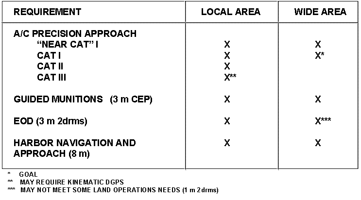
Table 4-2: DGPS Performance vs. Selected DoD Requirements
4.1.3 Integrity. To serve as a primary external navigation aid, UE must provide flight crews with integrity information. Integrity is defined as the ability of a radionavigation system to provide timely warnings to a user (pilot) to determine when the system should not be used for navigation to support the mission or phase of operation. For example, if a particular satellite falls below its performance threshold, the user needs either to not depend on GPS or to exclude that satellite's signal for determination of position. (Integrity = warning = safety & system confidence) Currently, GPS does not provide sufficient integrity for aviation operations in the National Airspace (NAS); as previously pointed out, GPS is scheduled to replace existing ground-based radionavigation systems. Precision guided munitions may also require integrity monitoring to avoid collateral damage and/or fratricide. Although GPS integrity requirements are not completely defined, it is anticipated that a warning and isolation function will be needed.
If GPS is to be employed as a supplemental (to other navigation systems) means of navigation, the DoD requirement is to provide the pilot with only a warning of below-specification performance. When GPS is to be employed as the primary means of navigation, warning plus continued availability of service by exclusion of the out-of-tolerance satellite is desired. Providing detection (warning) leads to service elimination; providing detection and exclusion allows service continuation.
4.1.4 Survivability. This performance area relates to the system's ability to continue to support the user in the face of unwanted electronic interference, intended or otherwise. An ongoing initiative is to continue to improve survivability performance to mitigate electronic interference. The technical focus is being applied to new electronic filters and modified antenna systems.
4.2 Advanced Technology Initiatives. As stated previously, the technical approaches being considered, in a number of instances, have applicability to more than one performance area; as an example, both integrity and accuracy can be improved with the implementation of DGPS.
To ensure mutually beneficial coordination of effort and sharing of resource application, the JPO has established close working relationships with other government agencies and laboratories at the forefront of the advanced technology community. The following are specific technology initiatives dealing with the integrity and accuracy performance areas:
4.2.1 Integrity Monitoring. There are two candidate technical solutions to integrity monitoring: Receiver Autonomous Integrity Monitoring (RAIM) and GPS Integrity Channel (GIC).
4.2.1.1 Receiver Autonomous Integrity Monitor. As the name implies, RAIM is an assessment of satellite(s) health (signals in/out of tolerance) which is performed within the receiver, depending solely on the GPS signals available without augmentation from another system. Figure 4-1 illustrates how the analysis is performed in the software. The receiver computes the position solution using a set of four satellite signals; in this case, with five satellites being tracked, five solutions can be developed. If there is an out-of-tolerance satellite, it is statistically predicted by comparing the solutions. If the system is designed to exclude the "bad" satellite, the tracking of at least six satellites would be necessary. The more satellites a receiver tracks, the more robust the solution. PPS RAIM is approximately 100 times better than SPS RAIM. Compliance with FAA TSO-C129 requires future implementation of RAIM for operations in the National Airspace; a number of commercially available receivers developed for civil aviation have been certified.

Figure 4-1: Receiver Autonomous Integrity Monitoring (RAIM)
4.2.1.2 GPS Integrity Channel. GIC is a technique that essentially employs a separate satellite health message (data block) transmitted from a separate system. Examples include DGPS (local-area and/or wide-area) communications satellites. Modifications to UE would be required to receive, interpret, and act on these messages. WAAS is planning to transmit a GIC message, thus supporting improved accuracy and integrity.
4.2.2 Differential GPS. Current Differential GPS techniques are based on measuring SPS signals from reference receiver(s) with known positions (benchmarks), calculating the errors (whether SA induced or not), and transmitting the corrections for UE to receive and apply to their position solutions. Figure 4-2 illustrates this approach; note that DGPS also corrects integrity problems.

Figure 4-2: Differential GPS
The satellite signals (carrier) transmit information (code). The reference receiver measures the range to satellites using one or both of the code-phase and carrier-phase of the signals. Measurements are compared to an estimate based on the true reference receiver position. Satellite clock and position (ephemeris) errors are almost eliminated. Values are differenced to create a range correction. Corrections are broadcast to users via a line-of-sight data link, pseudolite (a ground-based transmitter emulating a satellite), or communications satellite. The corrections are then applied by the UE.
4.2.2.1 Employment Concepts. Employment concepts for DGPS vary with the geometry and dynamic requirements of the application. They fall into two general categories: Local Area (LADGPS) and Wide Area (WADGPS).
Local-Area systems can provide airfield or theater-of-operations coverage and are typically ground-based and more accurate than WADGPS due to the limiting of the area for corrections determination; corrections include clock (timing) and ephemeris (satellite position) for those satellites in view and ionosphere (environmental) induced errors. The standard technique for determination of corrections employs the GPS code phase of the L1 (un-encrypted) signal. An order of magnitude better accuracy can be achieved by determination of corrections using the carrier phase of either/both the L1 and L2 (encrypted) signals; note that removal of Selective Availability effects is not necessary when comparing phase differences of the carrier signal, though it does simplify the computations required. This technique is known as Kinematic DGPS and supports applications requiring sub-meter accuracy (e.g., surveying, precision approach/landing, etc.). Accuracy performance improvement is addressed in the next section.
LADGPS can also be employed as a relative navigation system, illustrated in Figure 4-3. This approach is accomplished without utilization of a surveyed reference station (benchmark). The concept relies on all local users referencing a common set of reference corrections (gridlock). Application to naval operations are significant in that there is not the option or opportunity to survey a baseline position as a constant reference.

Figure 4-3: Relative Navigation Concept
Wide-area systems are typically space-based for the broadcast of correction signals over large areas. Pseudorange and regional ionospheric corrections are provided to the users with SPS applications; enroute navigation in the National Airspace is an example. GPS Satellite Vehicle (SV) clock and ephemeris corrections can be provided to PPS users. Section 4.2.2.3 addresses the FAA's WADGPS program known as WAAS.
4.2.2.2 DGPS Performance. DGPS performance varies based on the concept employed. Local area DGPS accuracies range from 1 to 4 meters SEP for relative navigation systems to < 20 centimeters for kinematic systems (Precision Approach applications). WADGPS offers 3 to 5 meters SEP due to its larger coverage area (regional instead of local ionospheric corrections (SPS) and satellite clock/ephemeris corrections).
The primary performance factor for LADGPS is the user's distance from a monitor station. WADGPS performance is primarily dependent on the number and geometry of monitor stations, and the quality of ionospheric corrections (SPS systems). WADGPS accuracy differs from LADGPS in that it is independent of the user's location; thus errors that are related to location and relation to where the error calculations are determined are only approximated.
4.2.2.3 Planned Systems. There are currently no DoD procurement plans for differential augmentation systems in direct support of mission areas; however, studies and tests are being conducted and evaluated. The DGPS-based Time/Space/Position Information (TSPI) system is being employed in DoD range instrumentation applications. Also, the Joint Direct Attack Munition (JDAM) SPO is considering a PPS-based WADGPS system as part of their Edge High Gear Program. The PLGR, the SOLGR, and a DMA survey receiver (all based on commercial off-the-shelf equipment), have SPS DGPS processing capabilities.
Drawbacks to DoD dependence on augmentation systems for increased accuracy include: 1) the requirement for modifications to both aircraft (need a data link for DGPS corrections) and UE, 2) the performance improvement from unencrypted DGPS cannot be guaranteed, 3) the vulnerability of DGPS stations in a combat theater, and 4) the possible reduction of operational flexibility at the expense of base-station placement. It is anticipated that once requirements coalesce, the DoD will implement the local and/or wide-area Y-code differential systems.
A number of DOT systems have been planned and are in varying stages of implementation. They include the FAA's Wide Area Augmentation System and Local Area Augmentation System (LAAS), and the Coast Guard's LAGPS (Intercoastal Waterway) System.
WAAS, planned for implementation in 1997, is intended to satisfy aviation requirements for enroute through Category I precision approaches. It will operate with several host geosynchronous satellites, a network broadcasting GPS-like Coarse Acquisition (C/A)-code ranging signals and 250 bps data message to provide DGPS corrections and integrity messages. A ground monitoring and control network is being developed that will be significantly larger than the GPS control network to compensate for only having access to SPS (and not PPS) signals. It should be noted that the unencrypted signal which FAA plans to transmit over the WAAS makes the system unsuitable for DoD combat operations due to susceptibility to jamming and spoofing.
LAAS is another differential augmentation system being planned for the 1997 time frame and beyond. It is a matrix of local area differential systems using ground-based pseudolites. LAAS is intended to support Category I through Category III precision approach services in addition to surface navigation, depending on the specific requirements of each location. Field DGPS reference stations would consist of reference receiver(s) and datalink hardware. Kinematic (carrier phase tracking) DGPS is a candidate employment technique. LAAS is to work independently of the WAAS, but provide for seamless transition between the two systems.
The US Coast Guard is fielding a ground-based LADGPS system for navigation throughout the Intracoastal Waterway System. Sixty-one sites are being implemented. Expansion of this system to cover the over-land areas of the United States is a potential future system upgrade.
5.0 Future Scan. Recognizing the adage "organizations that fail to plan - plan to fail," the JPO has devoted considerable effort to develop, maintain, and implement its own Strategic Plan. As part of this ongoing activity, an assessment of the future of GPS was conducted. Highlights of this assessment and its impacts on the JPO's mission and customers are addressed in this section.
5.1 Scenario/Environment. The future of GPS was assessed over two time periods. The first period spans the next five years. During this time, the civil (non-DoD) demand for, and dependence on, GPS will continue to expand the commercial market exponentially. This, in turn, will increase the slope of the current trend line of market-driven improvements to complementary technologies and manufacturing processes. The end result to DoD customers is, with minimal future DoD investment, continued improvements to system performance, unit costs, size, weight, power requirements, reliability, etc. New applications will proliferate, increasing the JPO's customer base. As a result of recommendations made by several studies commissioned at high levels of government and a Presidential Decision Directive (dated 29 March 96), the JPO will be coordinating closely with and responding to the DOT and other federal agencies representing civil, national, and international users. Greater cooperative government investment for developing and fielding commonly used GPS technologies and systems will be the by-product of this alliance. A new funding management system will be required that allows a streamlined method of pooling and dispersing investment and sustainment funds; this is necessary to expeditiously address new requirements from non-DoD customers.
The JPO will continue in its role as the Center of GPS Expertise, acting as a clearinghouse for all basic GPS architecture technologies and influencing policy with sound technical assessments. It will be necessary for the JPO to continue to proactively anticipate and address the issues and needs of both the DoD and non-DoD community. It will also be necessary to influence the development of technology and performance improvements before formal requirements exist.
Non-traditional integration of GPS is anticipated following the technology trends of information systems (integrated networks and software systems, etc.). GPS is becoming the backbone of the newest technology aircraft and weapons architectures; systems are being designed around and are dependent upon GPS capabilities. User equipment will become more complex in order to address emergent vulnerabilities, a factor and trend not unique to the DoD.
Looking into the future ten years hence, we see DoD's influence over GPS reducing in terms of policy, utility, and augmentations. Security and preservation of military advantage will remain important objectives. However, policy inputs will be received from the international community and will need to be addressed.
UE will be absorbed into other systems; this lends emphasis to current JPO efforts to engineer GPS to complement open system architectures. There will be even greater emphasis on electronic interference issues, with anti-jamming and denial technologies at the forefront of new and continued development.
5.2 Future JPO Roles. A re-alignment of policy and oversight at the national level will take place in recognition of the growing dependence on GPS as a worldwide utility. There will be a need for greater cooperative government investment for developing and fielding commonly used GPS technologies and systems (addressing issues/needs of non-DoD community). Forecasted GPS roles for the JPO are to:
- remain the central expert and clearinghouse for all basic GPS architecture technologies.
- expand JPO's role by representing civil, national, and international users.
- transition reprocurement, production, and sustainment functions to the supporting ALC (Sustainment of future UE will benefit significantly from increased reliability and maintainability.).
- maintain and update the GRAM standard, and control and distribute the SAASM specification; maintain a listing of approved vendors for GRAM and SAASM.
- continue to procure handheld units for all Services as new requirements are identified and new versions/applications evolve.
- continue as the center of expertise for GPS testing; continue to assist users with integration problems.
5.2.1 Security. Security will continue to be important in maintaining GPS as a force multiplier for US military forces, although the future widespread availability of differential systems may reduce the advantage enjoyed today. Future JPO security responsibilities will include to:
- refine technical approaches that will maintain the required degree of security; additional capabilities/enhancements will focus on security and survivability.
- monitor and participate in threat assessments.
- manage UE complexity to offset vulnerabilities, with emphasis on the capability to survive in a modern electronic warfare environment.
- remain the author and publisher of all GPS-specific security requirements documents.
5.2.2 Influencing Technology Development. There will continue to be an explosion of new applications necessitating continuing emphasis on the JPO's role as technology manager and consultant in order to accommodate new customers and products to satisfy new requirements and applications. In this role, the JPO will:
- coordinate closely with all GPS users to determine future UE requirements with enough advance notice to allow timely acquisition,
- coordinate closely with GPS UE manufacturers and R&D laboratories to stay abreast of the latest technological developments that may have an application to future GPS UE requirements, and
- support and participate in technology transfer to the private/commercial sector.
5.3 Upgrades/Pre-Planned Product Improvements (P3I). The employment of GPS will be integral to all DoD operations. Theater-wide integrated systems will rely not only on GPS's accurate positioning service, but also on its precision time output. Command, control, and communications will be exploiting GPS. Adversary use and dependence on GPS and other space-based navigation systems (e.g., Russia's GLONASS) will significantly increase. Maintaining GPS military utility in high electronic warfare environments will remain an important technical objective.
5.3.1 Receivers. A form, fit, and function-plus replacement for the first generation of GPS Receiver 3As and MAGRs is being planned; these receivers will be the 3AU and MAGRU (U = Upgrade). A follow-on handheld receiver is also planned for procurement. Direct P(Y)-code acquisition, integrity, field re-programmability, and enhanced anti-spoofing are the primary new capabilities planned for implementation. The Advanced Concept Technology Demonstration (ACTD) program will produce thirty 3AUs, thirty RF version MAGRUs, thirty IF version MAGRUs, and one hundred PLGRs. Follow-on production and replacement and retrofit of current UE will be decided based on the evaluation results of the capability demonstration.
Incorporation of these changes into receivers is being planned to avoid impacting integrations; the objective is for full backward-compatibility of the new LRUs to existing platform installations. Direct P(Y)-code acquisition implementation will be transparent to the host platform. Platform managers, at their own discretion, can take advantage of any advanced features that require integration modifications.
The next generation handheld receiver planned for procurement is the Defense Advanced GPS Receiver (DAGR). The DAGR procurement will ensure that there will be no production gap after the last PLGRs are delivered under the current contract (option IV). DAGR will also incorporate all mandated NAVWAR initiatives. Complementing the above listed advanced capabilities is a doubled battery life. It is expected to be an NDI acquisition, based on the new laws in the Federal Acquisition Streamlining Act. The quantity requirements could be well over 100,000.
In the area of specialty receivers, the Air Force and Navy have a requirement for a very small, flight suit/survival vest-portable GPS receiver and communications device to be used as an aid to downed aircrews and other isolated personnel. The Combat Survivor/Evader Locator (CSEL) system is under contract to Rockwell International, Autonetics and Missile Systems Division, Anaheim, CA and is currently in the Engineering/Manufacturing Development (EMD) phase of development. The CSEL system contains a space-based, a ground-based, and a UE segment. The UE Segment consists of Hand-held Radios (HHRs) and associated life support equipment. Thirty EMD HHRs are being built for pre-production developmental testing (DT) and OT which will occur in the April to June 1997 time frame. The initial production decision is scheduled for July 1997. Deliveries of the HHRs are expected throughout 1998 and 1999. The JPO is the lead acquisition organization for this program. A requirement for an interim CSEL-like device is presently in OT&E. The Hook-112 Program, a PRC-112 with GPS appliqué, made by Motorola Corporation, is expected to be fielded in late 1996.
A-J enhancements cross the boundary between receivers and antenna systems. The actual implementation approach remains to be determined and may be dependent on its intended application. Future A-J activities include integration and test of the filter designs in a GPS receiver (MAGR or 3A), integration and test of the A-J Multi-Chip Module (MCM) in a GPS receiver, A-J feasibility studies of filters' effectivity against jammers, and hardware development of beam forming and null steering antenna electronics.
5.3.2 Antenna Systems. In order to meet emerging anti-jam requirements, anti-jam antennas and antenna electronics will be acquired in two-steps: an interim non-developmental item acquisition to complete the GPS Project 2000 schedule, and a development acquisition based upon the results of an ongoing study, user determination of capabilities, and need date.
The GPS Antenna System (GAS-1) acquisition is the interim acquisition that will complete aircraft integrations in order to meet the Project 2000 mandate. Approximately 1,400 antenna electronics units and 800 antenna units will be acquired via an NDI acquisition. The acquisition will take advantage of current technology to improve anti-jam performance, reduce unit price, and improve reliability over current antennas. The interim system presents a low risk approach to the Project 2000 schedule. The contract will be issued in the last quarter of FY96. Deliveries will begin in late FY97.
Planning has begun for the next generation anti-jam antenna systems or electronics, the AE-F. The process leading to requirements documentation and scheduling of required funding has been initiated. In FY98, a development contract will be issued if user requirements and funding are in place. The contract is expected to be based on the anti-jam requirements for combat aircraft. Production of the AE-F is planned for competition in FY00. AE-Fs will then replace the older antennae (AE-1, AE-1A and GAS-1).
6.0 Conclusion. GPS's future is bright. Its precision accuracy has had a pervasive impact on navigation and has enabled the DoD and FAA to begin phasing out old, expensive, less-capable navigation systems. The DOT (with DoD collaboration) has begun work on developing a nationwide system, based on GPS, the Wide Area Augmentation System. It will provide the accuracy and safety necessary for GPS to be used as a primary means of navigation, enabling precision approach and landing based only on GPS. Additionally, GPS's time transfer capability has allowed global synchronization of electronic systems, facilitating secure communications, electronic warfare, and advanced target-locating techniques. One of the JPO's greatest challenges is to devise a dual-use strategy that allows economic exploitation of GPS technology while preserving the military advantages of the GPS system.
Predictions that affect the GPS program include greater DoD/Industry/International cooperation, increased competition for development and production resources, greater emphasis on productivity and streamlining, and an increased number of GPS JPO sponsored Government/Industry teaming initiatives.
Appendix A Table of Acronyms
|
3AU |
3A Upgrade (Receiver) |
|
ACC |
Air Combat Command |
|
ACTD |
Advanced Concept Technology Demonstration |
|
AE |
Antenna Electronics |
|
AE-F |
Anti-jam Antenna Systems or Electronics |
|
AFB |
Air Force Base |
|
AFSPC |
Air Force Space Command |
|
A-J |
Anti- Jam |
|
ALC |
Air Logistics Command |
|
AMC |
Air Mobility Command |
|
AOC |
Auxiliary Output Chip |
|
A-S |
Anti-Spoof |
|
ASC |
Aeronautical Systems Command |
|
ASD (C3I) |
Assistant Secretary for Defense for C3I |
|
ATACMS |
Army Tactical Missile System |
|
Auto-Nav |
Autonomous Navigation |
|
AWACS |
Airborne Warning and Control System |
|
BCIS |
Battlefield Combat Identification System |
|
C3I |
Command, Control, Communications & Intelligence |
|
C/A |
Coarse Acquisition |
|
CAG |
COMSAT Augmented GPS |
|
CDNU |
Control Display Navigation Unit |
|
CDU |
Control Display Unit |
|
CLS |
Contractor Logistics Support |
|
COE |
Center of Expertise |
|
COMSAT |
Communication Satellite |
|
CRAF |
Civil Reserve Air Fleet |
|
CREP |
Commercial Receiver Evaluation Program |
|
CRPA |
Controlled Reception Pattern Antenna |
|
CSEL |
Combat Survivor/Evader Locator |
|
CZW |
JPO's Logistics Support Group |
|
DAC |
Designated Acquisition Commander |
|
DAGR |
Defense Advanced GPS Receiver |
|
DGPS |
Differential GPS |
|
DISA |
Defense Information Systems Agency |
|
DMA |
Defense Mapping Agency |
|
DoD |
Department of Defense |
|
DOT |
Department of Transportation |
|
DSCS |
Defense Satellite Communications System |
|
DT |
Developmental Testing |
|
ECP |
Engineering Change Proposal |
|
EDT |
Engineering Development Test |
|
EGI |
Embedded GPS Inertial |
|
EMD |
Engineering/Manufacturing Development |
|
EPLGR |
Enhanced PLGR |
|
EW |
Electronic Warfare |
|
FAA |
Federal Aviation Administration |
|
FAASV |
Forward Area Armored Support Vehicle |
|
FMS |
Foreign Military Sales |
|
FOT&E |
Follow-On Operational Test and Evaluation |
|
FRP |
Full Rate Production |
|
FRPA |
Fixed Reception Pattern Antenna |
|
FY |
Fiscal Year |
|
GAS-1 |
GPS Antenna System |
|
GBCS |
Ground Based Common Sensor |
|
GIC |
GPS Integrity Channel |
|
GIG |
GPS Integration Guide |
|
GPS |
Global Positioning System |
|
GRAM |
GPS Receiver Applications Module |
|
GVRC |
GPS VME Receiver Card |
|
HHRs |
Hand-held Radios |
|
HMMV |
High Mobility Manned Vehicles |
|
ICD |
Interface Control Documents |
|
IF |
Intermediate Frequency |
|
ILS |
Integrated Logistics Support |
|
INS |
Inertial Navigation System |
|
IOT&E |
Initial Operational Test and Evaluation |
|
IPT |
Integrated Product Team |
|
IWSM |
Integrated Weapon Systems Management |
|
JCS |
Joint Chiefs of Staff |
|
JDAM |
Joint Direct Attack Munitions |
|
JPO |
Joint Program Office |
|
LAAS |
Local Area Augmentation System |
|
LADGPS |
Local Area Differential GPS |
|
LRIP |
Limited Rate Initial Production |
|
LRU |
Line Replaceable Unit |
|
m |
meter |
|
MAGR |
Miniaturized Aircraft GPS Receiver |
|
MAGRU |
MAGR Upgrade (receiver) |
|
MAJCOM |
Major Command |
|
MAPS |
Modular Azimuth Positioning System |
|
MCM |
Multi-Chip Module |
|
MCS |
Master Control Station |
|
MGRS |
Military Grid Reference System |
|
MLRS |
Multiple Launch Rocket System |
|
MOA |
Memoranda of Agreement |
|
MOD-SEM |
Modified Standard Electric Module |
|
NAPA |
National Academy of Public Administration |
|
NAVAIR |
Naval Air Systems Command |
|
NAS |
National Airspace |
|
NATO |
North Atlantic Treaty Organization |
|
NAVSSI |
Navigation Sensor System Interface |
|
NBC |
Nuclear, Biological, Chemical |
|
NDI |
Nondevelopmental Item |
|
NSA |
National SecurityAgency |
|
OASD |
Office of the Assistant Secretary of Defense |
|
OC-ALC |
Oklahoma City Air Logistics Center |
|
ORD |
Operational Requirements Document |
|
OSA |
Open Systems Architecture |
|
OSD |
Office of the Secretary of Defense |
|
OT |
Operational Testing |
|
OT&E |
Operational Test and Evaluation |
|
P3I |
Pre-Planned Product Improvement |
|
PLGR |
Precision Lightweight GPS Receiver |
|
PMD |
Program Management Directive |
|
PMRT |
Program Management Responsibility Transfer |
|
PPS |
Precise Positioning Service |
|
PPS-SM |
Precise Positioning Service - Security Module |
|
QT&E |
Qualification Test & Evaluation |
|
R&D |
Research & Development |
|
RAIM |
Receiver Antonymous Integrity Monitoring |
|
RTCA |
Radio Technical Commission for Aeronautics |
|
SA |
Selective Availability |
|
SAASM |
Selective Availability Anti-Spoof Module |
|
SCB |
SAASM Code Block |
|
SEP |
Spherical Error of Probability |
|
SGR |
Survey GPS Receiver |
|
SLGR |
Small Lightweight GPS Receiver |
|
SOLGR |
Special Operations Lightweight GPS Receiver |
|
SORD |
System Operational Requirements Document |
|
SPAWAR |
Space and Naval Warfare Systems Command |
|
SPD |
System Program Director |
|
SPO |
Systems Program Office |
|
SPS |
Standard Positioning Service |
|
STAR |
System Threat Analysis Report T |
|
Std-CDU |
Standard Control Display Unit |
|
SV(s) |
Satellite Vehicle |
|
T&E |
Test & Evaluation |
|
TACAN |
Tactical Air Navigation |
|
TGR |
Timing GPS Receiver |
|
THAAD |
Theater High Altitude Air Defense |
|
TSO |
Technical Standard Order |
|
TSPI |
Time/Space/Position Information |
|
TTFF |
Time-To-First-Fix |
|
TTSF |
Time-To-Subsequent-Fix |
|
UE |
User Equipment |
|
USAF |
United States Air Force |
|
USMC |
United States Marine Corps |
|
UTM |
Universal Transverse Mercator |
|
VME |
Versa Modula Eurocard |
|
WAAS |
Wide Area Augmentation System |
|
WADGPS |
Wide Area Differential GPS |
Appendix B Glossary of Terms
|
TERM |
DEFINITION/EXPLANATION |
3AU |
Future Upgrade to the Receiver 3A airborne GPS receiver. |
All-in-view satellite tracking |
The ability of a GPS receiver to simultaneously track all satellites within line-of-sight view of it's location. |
Almanac data |
Information stored in a GPS receiver containing satellite orbit data which aids in locating and tracking satellites when the receiver is first turned on. |
Antenna Electronics (AE) |
That unit which down converts the GPS RF signal received at the antenna to an intermediate frequency (IF) signal for input to the GPS receiver; also amplifies the signal. May also act as the null/beam steering device when used with a Controlled Reception Pattern Antenna. |
Anti-Spoofing (A-S) |
The satellite cryptographically modifies its plain text P-code signal into a cipher text code called Y-code to protect against spoofing. |
Auxiliary Output Chip (AOC) |
A security device used to generate internal Y-codes for correlation with the satellite-transmitted Y-codes to provide anti-spoofing protection. |
Avionics |
The general term applied to electronics boxes for aircraft applications. |
Carrier phase tracking |
A technique used to obtain phase information from the carrier signal; phase shifts (Doppler) indicate motion. |
Category I approach |
Precision approach term specifying minimum descent to 200 ft above the ground with as little as 1/2 mile visibility. |
Category II approach |
Precision approach term specifying minimum descent to 100 ft above the ground with as little as 1/4 mile visibility. |
Category III approach |
Precision approach term specifying minimum descent to 0 ft. with 0 miles visibility. |
Combat Survivor Evader Locator (CSEL) |
Aviator handheld survival radio capable of voice communication as well as short burst transmission of GPS position to aid Search and Rescue (SAR) efforts. |
Contractor Logistics Support |
Post-production/warranty hardware and software support handled by a civilian contractor, may or may not be manufacturer of the equipment. |
Control Segment |
Master Control Station in Colorado Springs, CO. and system of worldwide monitor stations, responsible for tracking and communication with satellites. MCS predicts satellite ephemeris and clock parameters, performs periodic uploads to satellites for transmission to users via the satellite navigation message. |
Controlled Reception Pattern Antenna (CRPA) |
A GPS antenna that is physically/electronically divided into multiple reception elements whose reception characteristics may be controlled by an antenna electronics unit. Effects of electromagnetic interference/jamming can be minimized on a directional basis to optimize satellite signal reception. |
Correlators |
Receiver circuitry designed to match up the received satellite signal with an internally-generated "replica" signal center frequency at the same phase to determine the "pseudorange" from the satellite. |
Cryptographic Keys |
Special digital codes which enable DoD receivers to receive and decode the PPS military signal. |
Differential GPS (DGPS) |
Reference stations provide correction signal to users based on difference between known reference position and GPS calculated position. |
Digital Battlefield |
Overall battlefield "picture" in digital format for display and use within digital processing equipment. |
Direct P(Y) code acquisition |
Locking onto the P(Y)-code of the satellite signal directly without having to find the coarse acquisition (C/A) code first. |
Embedded GPS Receiver |
A GPS receiver card or module embedded into and integrated with a different type of digital electronic box such as an inertial guidance system. |
Encrypted signal |
A signal which requires the receiver to be loaded with crypto "keys" in order to decode the signal. |
Engineering Change Proposals (ECP) |
Contractual means of implementing hardware and software changes to the design. |
Ephemeris data |
Specific satellite position information contained within the navigation message from each satellite; different from Almanac data which is data on the entire constellation available from each satellite. |
Federal Radio Navigation Plan |
Department of Transportation plan for implementation of radio navigation assets. |
Fixed Reception Pattern Antenna (FRPA) |
GPS antenna for receiving the RF signal from the satellites. This antenna has no nulling or beam steering capability. The output is fed into a downconverter (may be within the GPS receiver, or a separate component) for conversion to IF signal input to the GPS receiver. |
GPS Receiver Applications Module (GRAM) |
A GPS Joint Program Office module that will provide a standard GPS engine (standard functionality) for multi-application use within future navigation equipment, either in embedded or stand-alone applications. |
GPS VME Receiver Card (GVRC) |
Navy initiated GPS receiver card in a VME architecture as replacement to 3S receiver; will be embedded into shipboard navigation equipment. |
Group B equipment |
Line replaceable Units such as GPS receiver, antenna, antenna electronics, mounts, display units, etc. |
Hook-112 |
Interim program to update existing PRC-112 survival radios to include the capability to transmit GPS position. (see CSEL) |
Inertial Navigation System (INS) |
Navigation box which senses platform accelerations to measure velocity and derive position. |
Instrument Landing System (ILS) |
Ground-based precision approach system which provides precise azimuth and glide slope information for display on aircraft flight instruments; the microwave landing system (MLS) and GPS (augmented) can provide this also |
Integrated Product Team (IPT) |
Team of personnel of various disciplines established to be self-sufficient in accomplishing a particular process. At the JPO, projects are broken into IPTs. Some personnel may be members of multiple IPTs. |
Integrated Weapon Systems Management (IWSM) |
Air Force initiative to provide "cradle-to-grave" management and responsibility throughout the life-cycle for a weapon system by one program office. |
Integration |
Integration is the incorporation of one system into (or with) another in a fashion that they operate together. |
Integrity |
The ability of a radionavigation system to provide timely warnings to enable a user to determine when the system should not be used for navigation to support the mission or phase of operation. |
Integrity Monitoring |
The ability of the user to monitor the integrity of the GPS system and identify lack of integrity, and, if required, to isolate bad information. |
Interface Control Document (ICD) |
Defines the digital interface between systems/subsystems to enable cross communication. |
Intermediate Frequency (IF) Receiver |
A GPS receiver that requires an IF input; requires an external downconverter (antenna electronics) unit to convert the RF received at the antenna into a usable IF signal. |
Ionospheric delay |
Delay attributed to the refraction (bending) of RF signals from the satellites passing through the ionosphere. |
Integrated Software Support Facility (ISF) |
GPS organic software support facility at Warner-Robins-ALC; maintains, repairs, upgrades and develops GPS UE software. |
Jamming |
Intentional denial of the GPS signal by "drowning out" the satellite signals with artificial transmissions. |
JCS Master Navigation Plan |
Implements DoD Positioning and Navigation policy, validates Pos/Nav requirements, compares requirements to existing technology, identifies performance shortfalls, highlights needed research and development, and provides long-term projections of anticipated capabilities. |
Kalman Filter |
A mathematical tool that sorts out information and weights the relative contributions of measurements compared with its assumed model of the process; a recursive estimator that produces the minimum covariance estimate of the state vector in a least squares sense. |
Kinematic DGPS |
The technique employing determination of corrections using the carrier phase of either/both the L1 and L2 (encrypted) signals; offers an order of magnitude better accuracy than code-phase corrections determination. |
L1 |
One of the two L-band frequencies GPS broadcasts its signals on; 1575.42 Mhz. |
L2 |
One of the two L-band frequencies GPS broadcasts its signals on; 1227.6 MHz. |
Life-cycle cost |
The entire cost of a system from development, through production, and post-production logistics support. |
Line Replaceable Unit (LRU) |
An electronic box that is replaceable on the flight line by organizational maintenance personnel. |
Local-Area Differential GPS (LADGPS) |
Differential corrections provided by a locally positioned reference station. Limited to users within line-of-sight of the same satellites as the reference station. |
LRU Configurations |
The "set" of boxes that make up the GPS suite of a particular platform; i.e., receiver, antenna, antenna electronics. |
MAGRU |
Future upgrade to the Miniaturized Airborne GPS Receiver, inserting advanced technologies to improve performance and security. |
Manpack |
Original single-channel GPS receiver for use by ground personnel. Contained in a backpack for transport by unit navigator. Later replaced by newer, smaller, lighter, better handheld units. |
Miniaturized Airborne GPS Receiver (MAGR) |
Airborne improvement to the original Receiver 3A for use in high-dynamic platforms. Newer technology provided similar performance in approximately 1/3 the size and weight. Included reprogrammable capability. |
MOD SEM circuit card |
A modified version of the standard SEM form factor of circuit card; SEM is common to most avionics. |
Multipath |
The phenomenon of receiving the satellite signal multiple times due to time delays associated with reflection off of surroundings, such as buildings, terrain, etc.; responsible for the "ghosts" on your TV when using rabbit ears; can cause error in GPS position calculations. |
National Airspace (NAS) |
That airspace controlled by FAA for use by aircraft for enroute, approach, departure, and terminal operations. |
Navigation Sensor System Interface (NAVSSI) |
Navy shipboard system which consolidates inputs from multiple navigation and weapon systems to provide total battlefield situation awareness. |
Noise resolution |
The ability of a receiver to distinguish the satellite navigation signal from spurious noise sources. |
Non-Developmental Item procurement (NDI) |
Procurement of a system by the DoD that has already been developed for commercial/other use. Requires little or no development effort to adapt to the new requirement. |
Omega |
A radionavigation system; groundbased, large area. |
Operational Testing (OT) |
Testing by independent service agencies to assess the operational effectiveness and suitability of a weapon system. |
Organic Logistics Support |
Logistics support by a government agency, such as the Air Logistics Center at Warner-Robins AFB, GA; distinct from Contractor Logistics Support (CLS). |
P(Y)-code |
The Y-code is the P-code encrypted to protect against spoofing and can only be accessed by authorized users. |
PLGR mount |
A permanently attached bracket that a PLGR may be easily "plugged into" for use on a vehicle rather than handheld. |
Precise Positioning Service (PPS) |
Service available to authorized users that provides accuracy of £ 16 meters SEP position and 100 nanoseconds time transfer accuracy. |
Precise Positioning Service Security Module (PPS-SM) |
A tamper-resistant security device engineered to prevent reverse engineering; also provides secure storage for the GPS key. |
Precision Lightweight GPS Receiver (PLGR) |
The first DoD-procured handheld receiver with the capability of receiving the military PPS signal. |
Project 2000 |
The Air Force project to comply with congressional mandate to install GPS into all appropriate weapon systems by the end of fiscal year 2000 (30 Sep 2000). The mandate eliminates any further funding for any weapon system that has not complied. |
Pseudolites |
A ground-based transmitter emulating a satellite; used for testing, range applications and as reference stations in DGPS systems. |
Pseudorange |
Range measurements between the GPS receiver and the individual satellites, uncorrected for receiver clock bias. |
Radio Frequency (RF) Receiver |
A GPS receiver that accepts the GPS RF signal directly from the GPS antenna rather than from an antenna electronics downconversion to IF. The receiver performs an internal downconversion. |
Receiver Autonomous Integrity Monitoring (RAIM) |
A software algorithm that performs an assessment of satellite(s) health (signals in/out of tolerance) done within the receiver; depending solely on the GPS signals available without augmentation from another system. |
Receiver Channels |
Independent processing of different satellite signals and performance of various internal "housekeeping" functions. The more channels a receiver has available, the more satellites it may track simultaneously, and may have channels dedicated to other functions, such as RAIM, satellite selection, etc. |
Relative Navigation |
Navigation based on platform positions relative to each other rather than an absolute geographical position. |
Retrofit integration |
Post-production integration into an existing platform design. |
Reverse Engineering |
The ability to determine the hardware and/or software design, based on known inputs and outputs of various components. In essence, the process of working backwards from "solution" to design. |
Security Devices |
Devices that are incorporated into DoD receivers in order to allow access to the PPS and SA; they perform the basic cryptographic functions for GPS UE to include the generation of Y-Code and removing the effects of Selective Availability. |
Selective Availability (SA) |
The introduction of errors in the satellite ephemeris parameters along with encrypted correction parameters which allow certain users to remove the effects of those errors. |
Selective-Availability/Anti-Spoof Module (SAASM) |
A state-of-the-art microelectronics module that incorporates all aspects of selective availability (PPS-SM functions), anti-spoofing (AOC function) and supports workable electronic keying. |
Situational Awareness |
Maintaining the "big picture" of the battlefield situation via multiple sensor inputs. |
Small Lightweight GPS Receiver (SLGR) |
A handheld receiver procured on an emergency basis to fulfill Desert Storm requirements for handheld receivers not yet available through normal development; provided C/A code tracking only. |
Sole-source procurement |
A procurement that does not follow the normal "competition" process. Usually requires an official waiver based on "Justification and Approval" documentation. |
Spherical Error Probable (SEP) |
The 3-dimensional positioning accuracy to the 50th percentile probability level. |
Spoofing |
The intentional deception of a GPS receiver by a simulated satellite signal designed to produce an error in the navigation solution. |
Stand-alone GPS |
A GPS receiver that is not integrated with any other navigation or weapon system. The output is only derived by GPS signals. |
Standard Positioning Service (SPS) |
Service available to all users that provides accuracy of £ 100 meters (95%) horizontal position during peacetime and 337 nanoseconds time transfer accuracy. |
Tactical Air Navigation (TACAN) |
TACAN is a ground-based UHF radionavigation system which provides a pilot with relative bearing and distance to a beacon on the ground, ship, or to specially equipped aircraft. This system is planned for phase-out and replacement by GPS as the primary tactical navigation system for the military services ashore and afloat. |
Tropospheric delay |
Delay attributed to the refraction (bending) of RF signals from the satellites as a result of travel through the troposphere. |
Versa Modula Eurocard (VME) |
VME is a very common form factor in both commercial and DoD computer systems (form factor relates to the shape of the card and how it communicates with its host installation - a "rack" or "bus"). |
Variable Omni Range/Distance Measuring Equipment (VOR/DME) |
An older ground- based navigation aids that provide the pilot with relative bearing and distance to beacons on the ground. The VOR/DME stations within CONUS define the Air Route Traffic Control system of National Airspace airways. |
Wide-Area Differential GPS (WADGPS) |
Differential corrections provided by space-based transmitters over a wide area. |
INDEX
|
NEWSLETTER
|
| Join the GlobalSecurity.org mailing list |
|
|
|