

Notes for the December 1995 Baseline GBS Link Calculation
1. The baseline link calculation is based on an implementation that the Government believes is achievable. The Government is receptive to:
• A different balance of uplink and downlink performance that leads to the same composite performance.
• A different composite performance with attenant programmatic benefits (e.g. in throughput, risk, or cost).
Contractors presenting variations from the baseline link should provide the technical data that supports the viability of their design. Contractors presenting an alternate level of performance should detail both the programmatic benefit(s) expected and the positive and negative trade factors relative to the baseline and the rationale for the contractor’s trade conclusions.
2. The government’s link calculation is structured to end with the margin available to counter atmospheric losses. (An iteration process adjusts receive antenna temperature so that the receive terminal G/T corresponds to the atmospheric loss margin at the end of the link calculation.) The atmospheric loss margin, the satellite locations, and the link elevation angle are inputs to a computer program which iterates the link performance over that portion of the earth’s surface visible to each satellite. Using Crane’s model for rain attenuation and the NASA Propagation Handbook for gaseous attenuation, the program calculates the downlink availability at each point. The effect of uplink availability, if significant, can be included. The program output is a world map color-coded to show link availability, supplemented by a legend that shows the percentage of the earth’s surface in each availability band.
3. The technical tiger team supporting the judgments presented in the attached link budget consisted of representatives from:
Aerospace Corporation
Lincoln Labs
Mitre
Stanford Telecom
26 March 1996
1 GBS Link Calculation Downlink Comments
2 December 1995 baseline Details
3
4 Frequency, GHz 20.7 mid band
5 Bit Rate, Mbps 24.0
6
7 Transmitter power,W 120
8 Transmit antenna diameter, in 26
9 Transmit antenna efficiency 0.6
10 Transmit antenna peak gain, dB 40.9
11 3 dB beamwidth, deg 1.5
12 Pointing error, deg 0.10
13 Beam edge vs peak gain, dB 3.0 chosen to get =>500 nmi spot
14 Transmit beamwidth, deg 1.5
15 Beam diameter, nmi 511 at nadir, without pointing loss
16 Transmit pointing loss, dB 0.8 from lines 11 and 12
17 Transmit line & muxing loss, dB 2.0
18 EIRP at edge of beam, dBW 55.8 combine lines 7, 10, 13, 16, 17
19 EIRP at peak of beam, dBW 59.7 reference only; edge EIRP used in following lines
20 Space loss, dB -210.7 20 deg elevation
21 Other losses, dB 0.5 polarization mismatch & ground pointing
22 Ground G/T, dB/K 12.5 18” antenna; antenna temperature matches loss in line 31
23 Bandwidth, dB-Hz 73.8 from line 5
24 Boltzmann, dB/Hz-K -228.6
25 Available Eb/No, dB 11.9 combine lines 18, 20-24
26 Required Eb/No, dB 5.0 includes coding gain and implementation loss
27 Degradation due to uplink, dB 0.0 uplink ~20 dB stronger
28 Interference degradation, dB 0.4 due to other satellites’ downlinks
29 Total margin, dB 6.5
30 Program Manager’s margin, dB 1.0 government reserve
31 Margin for atmospheric loss, dB 5.5 gaseous plus rain
Uplink
Sketch
36 Frequency, GHz 30.5 mid band
37 EIRP, dBW ~93 per transponder
38 Atmospheric loss, dB ~30 unavailability ~0.1X downlink
39 Satellite G/T, dB/K ~25 narrow rcv beam reduces jamming vulnerability
40 Required Eb/No, dB ~26 negligible degradation to composite Eb/No
Notes for the December 95 Strawman GBS GLIMPSE plot
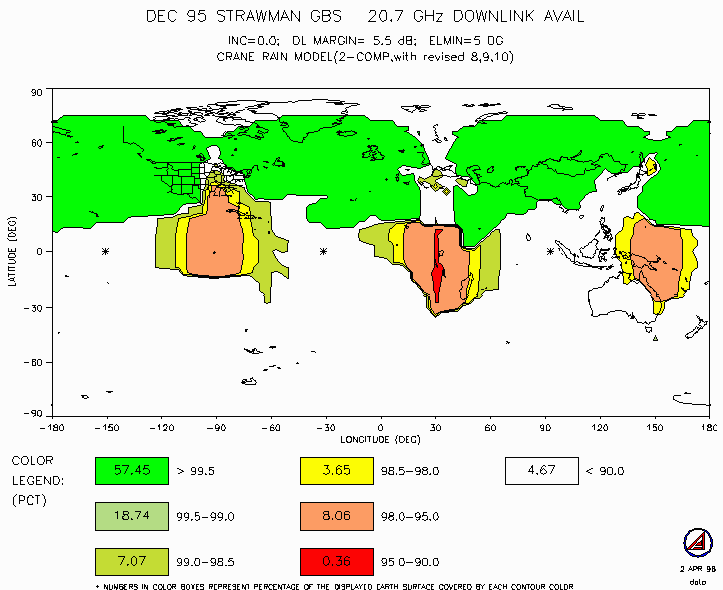
1. This global plot is generated by performing a geographic point-by-point calculation of the annual average availability loss caused by gaseous and rain attenuation on a 3x3 Deg grid of the earth. Necessary inputs to the model include:
a) Transmit frequency (we use center of band)
b) Transmitting satellite locations
c) Receive terminal beamwidth
d) Link margin available for overcoming atmospheric losses as calculated by or reconciled with the link budget procedures presented in the Baseline GBS Link Calculation above. This link margin can be quoted for any (specific) elevation angle, but using a 20 Deg elevation angle is preferred for consistency.
2. The GLIMPSE model takes the inputs defined above the calculates the difference in range and elevation angle from the reference geometry for each point on the earth. It then uses Crane’s model for rain attenuation and the NASA Propagation Handbook for gaseous attenuation to calculate the availability variation based on atmospheric attenuation.
3. The Crane model used in GLIMPSE was reviewed and updated based upon inputs from a technical tiger team consisting of representatives from:
Aerospace Corporation
Lincoln Labs
Mitre
Stanford Telecom
Notes for the plot of “Neighboring Ka-Band Sats”
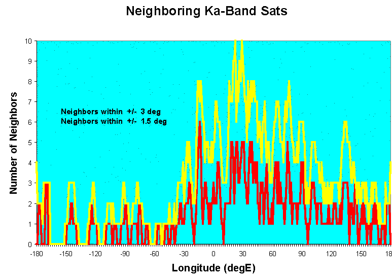
1. This plot shows the number of neighboring satellites at Ka-band, based on ITU filings as of November 1995, in geosynchronous orbit using a sliding window stepped in increments of 1.0 Deg longitude. The red curve gives the number of satellites within 1.5 Deg of the indicated longitude, and the yellow curve the number within 3.0 Deg. These values were suggested by the Joint Spectrum Center as representing rules of thumb on the difficulty of achieving satisfactory coordination with the county having filed for the neighboring satellite slot. Within 1.5 degrees coordination is unlikely. Between 1.5 and 3.0 degrees coordination may be possible, but may result in significant operational constraints being imposed.
|
NEWSLETTER
|
| Join the GlobalSecurity.org mailing list |
|
|
|