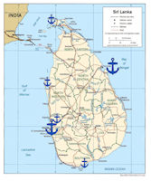
Sri Lanka Navy - Bases
 The navy maintaine major bases in Colombo and Trincomalee, with secondary bases at Karainagar (Jaffna District, NW of Jaffna), Welisara (inland at Ragama in Colombo District, 10 km from Colombo), Tangalla (aka Tangalle, in Hambantota District, at the Southern end of the island), and Kalpitiya (Puttalam District).
The purpose of the Small Boat Concept was to counter the Sea Tigers with large numbers of small high-speed, heavily armed inshore patrol craft (IPC). The boats were organized into Rapid Action Boat Squadrons (RABS) totaling 25 to 30 craft. The squadrons were stationed in high-threat locations along the northern and eastern coast to enable them to rapidly respond to and interdict Sea Tiger units at sea.
Naval camps were set up along the northern and eastern coast to provide bases for the RABS and land-based radar systems. The radars proved to be an essential element of the SLN’s ability to defeat the Sea Tigers. In 2006, small land-based radar stations were set up along the coast from Point Pedro in the north to Trincomalee in the east. The only area not covered was an LTTE stronghold between Chundikkulam and Mullaittivu. In November 2007, the United States provided Sri Lanka with a radar-based maritime surveillance system.
Sri Lanka has 3 main commercial harbours viz, Colombo in the West, Galle in the South and Trincomalee in the North East. Colombo and Galle are man made while Trincomalee commands a large natural and a wide body of sheltered water. It is 10 times larger than the Port of Colombo.
Sri Lanka is an extension of the south Indian plateau. It is separated from India by Palk Strait (20 statute miles (32 km) wide at its narrowest) and by the Gulf of Mannar. Mannar Island, off Sri Lanka's northwest coast, and the nearby shallows known as Adam's Bridge virtually connect the island to the mainland. Sri Lanka's greatest length is 270 statute miles (435 km) and its widest point is 140 statute miles (225 km).
Sri Lanka has three main topographical regions: the mountains, the coastal plain and the coast. The mountains in the south central section rise to jagged peaks 7000 to 8000 ft (2100-2400 m) high. Highest is Pidurutalagala (Mount Pedro) at 8291 ft (2527 m). Best known of the peaks is Sri Pada (Adam's Peak), 7360 ft (2243 m), a landmark that was familiar to ancient navigators. A coastal plain in the island's southern section broadens into an extensive flat, dry region north of the mountains. The coasts are rimmed by sandy beaches. The force of the surf is diminished by coral reefs, sand banks and shoals. The only great natural harbor is at Trincomalee on Koddiyar Bay on the northeast coast.
China is building a $1 billion commercial port facility on the southern coast of Sri Lanka that might also support Chinese naval operations. Ever since Sri Lanka agreed to the plan, in March 2007, China gave it all the aid, arms and diplomatic support it needed to defeat the Tigers, without worrying about the West. The Hambantota Harbor and international commercial airport developments are expected to transform Sri Lanka into a global mega hub, on par with the United States Pacific Coast, the United States Atlantic Coast, European, and Far Eastern mega hubs. When completed, the port will have approximately ten times the capacity of Singapore or Rotterdam, and will be the only major commercial shipping hub between Singapore and Fujairah. This isparticularly important as over 45 percent of the world’s trade transits within 10 miles of this port, so international shipping companies will incur no deviation costs to bring a ship into this port.
Sri Lanka’s Ports, especially the Port of Colombo and the new Mahinda Rajapaksa Port in Hambantota (Magampura) are strategically located. Equipped with state of the art facilities, these Ports can provide economic advantage for businesses in the region, especially for those in India. The objective of Sri Lanka’s post-conflict development plan is to utilise Sri Lanka’s strategic geographic location effectively and develop Sri Lanka as a shipping, aviation, commercial, energy and knowledge hub serving as a link between East and West.


|
NEWSLETTER
|
| Join the GlobalSecurity.org mailing list |
|
|
|

