Palau - Geography
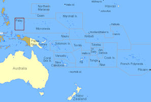
 Palau, part of the Caroline Islands group, is the westernmost archipelago in Oceania, located 741 km east of Mindanao in the southern Philippines and about 1,300 km southwest of Guam.
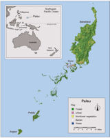
Palau stretches over 700 km of ocean from about 2 to 8 degrees north latitude and 131 to 135 degrees east longitude. It is about 500 miles equidistant from the Philippines to the west and from Papua New Guinea to the south. It consists of more than 340 islands, of which only 9 are inhabited. These are, from Northeast to Southwest: Kayangel, Babeldaob, Koror, Peliliu, Angaur, Sonsorol, Pulo Anna, Hatohobei, and Helen Reef.
The archipelago consists of a clustered island group (including Babeldaob, Koror, Peleiu, Angaur, Kayangel, Ngeruangel, and the Rock Islands) and six isolated islands (Helen Reef, Tobi, Merir, Pulo Anna, Sonsorol, and Fana) that lie approximately 340 to 600 km to the southwest (Figure FAS-4). Babeldaob, the second largest island in Micronesia after Guam, is the biggest island in the Palauan chain; however, the country’s capital and greatest population is located on Koror. The volcanic island of Babeldaob and its reefs are separated from Koror and the southern islands of the group by a deep (30 to 40 m), east-west pass called Toachel El Mid.
Babeldaob is the largest island, making up 80 percent of the total land area. Babeldaob Island consists of ten states, namely, Airai, Aimeliik, Ngeremlengui, Ngerchelong, Ngchesar, Melekeok, Ngiwal, Ngaraard, Ngardmau and Ngatpang States. Including the states in Babeldaob, there are altogether 16 States in Palau.
Palau covers 458 sq. km. (about 190 sq. mi.) in eight main islands plus more than 250 islets. The surrounding sea area is very large, including an exclusive economic zone extending over 237,850 square miles. Palau’s distance to major cities in nautical miles: Guam (722 miles), Hong Kong (1,739 miles), Honolulu (4,449 miles), Manila (528 miles), San Francisco (5,751 miles), Shanghai (1,679), Sydney (3,319), and Tokyo (1,890 miles). The Palau Island is 9 hours ahead of Greenwich Mean Time. Palau is in the same time zone as Japan.
The capital of Palau is located in Koror with a land area of 7.1 square miles where two thirds of the population resides. Koror lies just south of Micronesia’s second largest island, Bebeldaob, which contains 153 square miles of undulating forests, grasslands, rivers, waterfalls, wetlands, mangroves and some of the most beautiful stretches of beaches.
Palau is currently about 82 percent forested, which includes agroforest and secondary forest vegetation. About 2 percent of the landscape was classified as urban land and about 14 percent was classified as nonforest vegetation including savanna and agricultural lands. The area for land cover estimates totaled 110,028 acres. Trends suggest there may be some areas of Babeldaob where nonforest vegetation has reverted to forest. On Peleliu and Koror, it appears that forest land is being converted to urban and nonforest vegetation uses.
Palau is well known for its tremendous diversity and concentration of both terrestrial and marine life along the network of coral reefs and the chain of more than 300 raised limestone and volcanic islands. Throughout the year the climate is hot, tropical and humid. Rainfall averages 3700-mm per year, ranging from 3150 to 4400-mm, with February to April the driest and the mean daily temperature is 27°C with a mean diurnal range of 7°C. Freshwater is limited, with only one sustained stream flow on the large volcanic island of Babeldaob. Freshwater lenses are also found beneath some of the atolls. Palau has a flora that is richer than any other area of Micronesia, with a large number of endemic species, the combined result of proximity to Asia and isolation.
The tremendous marine diversity is supported by the convergence of oceanic currents and the filtering and nutrient effects of the dense terrestrial forests. The topography of the four volcanic islands is marked by steep slopes and rolling hills, with mangroves often found on coastal flats. The limestone coral islands or “Rock Islands” support a diversity of tree species on often surprisingly shallow soils deposited in the recesses of the rugged karstic topography. The highest point in Palau is the approximately 700-foot-tall Mount Ngerchelchuus on Babeldaob.
Most of the islands are of volcanic origin, and others are of raised limestone. Palau has numerous island and reef types, including volcanic islands, atolls, raised limestone islands, and low coral islands. A barrier reef surrounds much of the main island cluster, from the northern tip of Babeldaob down to the southern lagoon, merging into the fringing reef with Peleliu in the south. Palau has the most diverse coral fauna of Micronesia and the highest density of tropical marine habitats of comparable geographic areas around the world.
Palau has already done a great deal toward limiting the impacts of tourists on reef resources. Mooring buoys, laws preventing the collection of corals, and diving tour operator education help conserve the culturally and economically important reef resources. The largest direct impact on some reef sites is now the volume of divers with varying levels of training. Increased sedimentation is another major threat to coral reef ecosystems worldwide .
The Pacific Ocean evolved from the Panthalassic Ocean that was first formed ca 750 Ma with the rifting apart of Rodinia. By 160 Ma, the first ocean floor ascribed to the current Pacific plate was produced to the west of a spreading centre in the central Pacific, ultimately growing to become the largest oceanic plate on the Earth. The current Nazca, Cocos and Juan de Fuca (Gorda) plates were initially one plate, produced to the east of the original spreading centre before becoming split into three. The islands of the Pacific have originated as: linear chains of volcanic islands on the above plates either by mantle plume or propagating fracture origin, atolls, uplifted coralline reefs, fragments of continental crust, obducted portions of adjoining lithospheric plates and islands resulting from subduction along convergent plate margins.
There is a great diversity of landforms and substrates for such a small area as Palau. The archipelago can be subdivided into four geological types. The volcanic islands Babeldaob, Ngerekebesang (also known as Arakabesan, Meiuns or Meyungs), Ngemelachel (or Malakal) and the western part of Oreor (or Koror) comprise most of the land area. Seven reefs and atoll islands are located north and northeast of Belilou (or Peleliu). The southwestern islands are a combination of low platform islands and atolls, while the 300 central and southern islands form steep coralline limestone rock islands. Substantial phosphate reserves were mined during the German and Japanese administrations.
The main island of Babeldaob (78% of the total land area) comprises in part old-weathered continental rocks that have been the source of some gold. Between 50 and 27 Ma, the Kyushu–Palau Ridge was a very active volcanic arc formed above the westward subducting Pacific plate. High-magnesium boninites and island arc tholeites were produced during Late Eocene time by rapid magma production. The Kyushu–Palau Ridge subsequently split off from the Bonin Islands ca 30 Ma, by sea-floor spreading of the Parece Vela basin. In Palau, the volcanics are dated between 37.7 and 20.1 Ma. They are in turn overlain by Mid-Oligocene limestone oozes, indicative of subsequent subsidence. Rotation of the PS plate gradually led to a convergent plate boundary with the Caroline plate to the southeast, with subsequent uplift of the islands raising Miocene limestones to 220m asl, forming a limestone cap with surrounding raised coral platforms and reefs. A 4000-year-old limestone on Oreor has been subsequently uplifted 2m, i.e. current average rate of uplift is 0.5mmyr-1.
|
NEWSLETTER
|
| Join the GlobalSecurity.org mailing list |
|
|
|


