Boundaries and Boundary Disputes
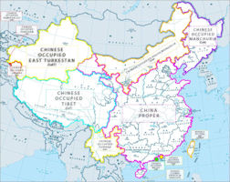
Beijing has since 2000 resolved territorial disputes by demarcating boundaries with Kazakhstan, Kyrgyzstan, Russia, Tajikistan, and Vietnam. Land boundary negotiations continue with Bhutan and India. China established a maritime boundary with Vietnam in the Gulf of Tonkin in 2000 but has no maritime boundaries in the Yellow Sea, East China Sea, and South China Sea, where it lays competing claims to islands and waters.
China's borders, more than 20,000 kilometers of land frontier shared with nearly all the nations of mainland East Asia, were disputed at a number of points. In the western sector, China claimed portions of the 41,000-square-kilometer Pamir Mountains area, a region of soaring mountain peaks and glacial valleys where the borders of Afghanistan, Pakistan, the Soviet Union, and China meet in Central Asia. North and east of this region, some sections of the border remained undemarcated at the end of the Cold War.
The China-Burma border issue was settled October 1, 1960, by the signing of the Sino-Burmese Boundary Treaty. The first joint inspection of the border was completed successfully in June 1986.
The 6,542-kilometer frontier with the Soviet Union had been a source of continual friction. In 1954 China published maps showing substantial portions of Soviet Siberian territory as its own. In the northeast, border friction with the Soviet Union produced a tense situation in remote regions of Nei Monggol Autonomous Region (Inner Mongolia) and Heilongjiang Province along segments of the Ergun He (Argun River), Heilong Jiang (Amur River), and Wusuli Jiang (Ussuri River). Each side had massed troops and had exchanged charges of border provocation in this area. In a September 1986 speech in Vladivostok, Soviet leader Mikhail S. Gorbachev offered the Chinese a more conciliatory position on Sino-Soviet border rivers. In 1987 the two sides resumed border talks that had been broken off after the 1979 Soviet invasion of Afghanistan.
In the early 1990s, relations got a boost from China's interest in renewed weapons imports from Russia and other forms of military cooperation. In December 1992, Yeltsin went to China and signed a nonaggression declaration that theoretically ended what each called the other's search for regional hegemony in Asia. Chinese party chairman Jiang Zemin visited Moscow in September 1994 and concluded a protocol that resolved some border disputes and generally strengthened bilateral ties. During Yeltsin's visit to China in April 1996, both sides described their relationship as evolving into a "strategic partnership," which included substantially increased arms sales. At the April meeting, new agreements made progress toward delineating and demilitarizing the two countries' 3,645 kilometers of common border. Although border security and illegal Chinese immigration into the Russian Far East were controversial issues for Russian regional officials, Yeltsin demanded regional compliance with the agreements.
A major dispute between China and India focuses on the northern edge of their shared border, where the Aksai Chin area of northeastern Jammu and Kashmir is under Chinese control but claimed by India. Eastward from Bhutan and north of the Brahmaputra River (Yarlung Zangbo Jiang) lies a large area controlled and administered by India but claimed by the Chinese in the aftermath of the 1959 Tibetan revolt. The area was demarcated by the British McMahon Line, drawn along the Himalayas in 1914 as the Sino-Indian border; India accepts and China rejects this boundary. In June 1980 China made its first move in twenty years to settle the border disputes with India, proposing that India cede the Aksai Chin area in Jammu and Kashmir to China in return for China's recognition of the McMahon Line; India did not accept the offer, however, preferring a sector-by-sector approach to the problem. In July 1986 China and India held their seventh round of border talks, but they made little headway toward resolving the dispute. Each side, but primarily India, continued to make allegations of incursions into its territory by the other.
China, Taiwan, and Vietnam all claim sovereignty over both the Xisha (Paracel) and the Nansha (Spratly) islands, but the major islands of the Xisha are occupied by China. The Philippines claims an area known as Kalayaan (Freedom Land), which excludes the Nansha in the west and some reefs in the south. Malaysia claims the islands and reefs in the southernmost area, and there also is a potential for dispute over the islands with Brunei.
Liu Jianfei wrote in 2012 that "The issue of sovereignty of the territorial land and waters could easily arouse extreme nationalism. Some people who are highly focused on this issue in fact know little about the history and strategy underlying the disputes. They are inclined to adopt hard-line measures in order to ensure that sovereignty is assured, whilst displaying their dissatisfaction with the policies set by the ruling parties and government. The highly advanced state of new media provides a convenient platform for these people to air their views, and disputes have the potential to incite the public’s dissatisfaction with the government, and even the basic system of the country."
Southeast Asian countries and Taiwan on 31 August 2023 objected to China’s latest version of its territorial map because of new boundaries that reach waters they claim as well in the South China Sea. Beijing released the map on 28 August 2023 amid tensions with the United States over Taiwan, and days after China Coast Guard ships formed a cordon to block Philippine supply boats delivering supplies to the BRP Sierra Madre, Manila’s military outpost in Ayungin Shoal (Second Thomas Shoal), in the disputed waters. The Philippines rejected the 2023 version of China's Standard Map issued by the Ministry of Natural Resources of the People's Republic of China on August 28, 2023, because of its inclusion of the nine-dashed line (now a ten-dashed line) that supposedly shows China's boundaries in the South China Sea. The Departmentof Foreign Affairs stated 31 August 2023 "This latest attempt to legitimize China's purported sovereignty and jurisdiction over Philippine features and maritime zones has no basis under international law, particularly the 1982 United Nations Convention on the Law of the Sea (UNCLOS). The 2016 Arbitral Award invalidated the nine-dashed line. It categorically stated that. "maritime areas of the South China Sea encompassed by the relevant part of the 'nine- dash line' are contrary to the Convention and without lawful effect to the extent that they exceed the geographic and substantive limits of China's maritime entitlements under the Convention." The Philippines, therefore, calls on China to act responsibly and abide by its obligations under UNCLOS and the final and binding 2016 Arbitral Award."
Among the territory included in the updated edition of map is the Indian state of Arunachal Pradesh, China’s long-time claim as the southern part of Tibet, and Aksai Chin, the arid northern extension of Ladakh occupied by China since the end of the 1962 Sino-Indian War. Many of the regional allies of the U.S. happen to have territorial disputes with China, particularly Japan and the Philippines.
Fellow ASEAN members Malaysia, Indonesia and Vietnam, along with Taiwan, also spoke out against the new map. “Taiwan, the Republic of China, is a sovereign and independent country that is not subordinate to the People’s Republic of China,” said Jeff Liu, spokesman for the foreign ministry of Taiwan, which China considers a renegade province. “The People’s Republic of China has never ruled Taiwan. These are universally recognized facts and the status quo in the international community,” he said.
China claims nearly the entire South China Sea, including waters within the EEZs of Brunei, Malaysia, the Philippines, Vietnam and Taiwan. In Jakarta , Indonesian Foreign Minister Retno Marsudi told reporters that the government had always maintained that any claim must be consistent with UNCLOS.
Russia and China have no territorial claims to each other, said Foreign Ministry spokeswoman Maria Zakharova 31 August 2023, commenting on the situation around the ownership of Bolshoi Ussuriysky Island. "The Russian and Chinese sides adhere to a unified position that the border issue between our countries has been finally resolved. <...> Russia and China have repeatedly confirmed the absence of mutual territorial claims, the corresponding provision is also in the Treaty on Good Neighborliness and Friendship, which is basic for bilateral relations and cooperation dated July 16, 2001," the ministry's website said in a statement. According to Zakharova, in 2005 Moscow and Beijing ratified an additional agreement on the Russian-Chinese border. According to the agreement, the parties divided Bolshoy Ussuriysky Island among themselves. The delimitation and demarcation of the border in this area was completed three years later.
This new geographical map was officially approved in China. On them, part of the territory of Russia is recognized as the territory of the People’s Republic of China. The Great Ussuri Island on the Amur River is marked as Chinese lands. China and Russia, and earlier the USSR, have been arguing about the ownership of this territory since 1964. And in 2008, Moscow and Beijing signed an agreement according to which the island was divided between the two countries. On the new official map, China marks the entire island as the eastern point of Chinese territory.
The further complication there is that this island is located at the confluence of two rivers, and because of this the contours of the island change from time to time, and this causes difficulties in correctly interpreting the situation where the actual border passes, because the island is roughly in half was divided between them. And, by the way, the Chinese part of the island is quite developed, the Chinese made a large national park there, a very large number of tourists go there every year. And it has become a kind of place that is used for national mobilization of people who visit this area. On the other hand, the Russian part of the island is depressed and poorly maintained. Almost nothing develops there, there is practically no tourism, it is a kind of semi-closed border zone with all the consequences that follow from this. And this is an example of how some people can work with territories, other people do not know how to work with territories, but, nevertheless, try to capture and get even more territory under their control.
|
NEWSLETTER
|
| Join the GlobalSecurity.org mailing list |
|
|
|


