

Navionics® Boating
Contains adsIn-app purchases

4.1star
42.8K reviews
5M+
Downloads

Rated for 3+
info


About this app
Get up-to-date, detailed charts you can use offline plus a boatload of features on your mobile device, so they’re on hand wherever you go. The Boating app is a must-have for cruising, fishing, sailing, diving and all your activities on the water. Try it free for a limited time. To continue using charts and advanced features, you can purchase a yearly auto-renewable subscription*.
A COMPLETE PACKAGE
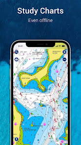
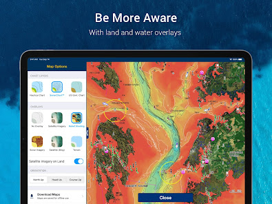
• INTERNATIONALLY RENOWNED NAVIONICS® CHARTS: Use them offline along with multiple overlays, so you can be more aware of what’s above and below the water.
- NAUTICAL CHART: Use this premier marine reference to study port plans, anchorages and safety depth contours, locate navaids, marine services and more.
- SONARCHART™ HD BATHYMETRY MAPS: Extraordinary 1’ (0.5 meter) HD bottom contour detail is the ideal tool for locating new fishing areas.
- U.S. GOVERNMENT CHARTS (NOAA): These are available within the following coverages: U.S. and Canada, Mexico, Caribbean to Brazil.
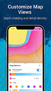
- OVERLAYS: The relief shading overlay allows you to have a better understanding of bottom topography for improved fishing and diving. Sonar imagery reveals bottom hardness clearly and in vivid color on select lakes. Want more? Display satellite imagery on land and water.
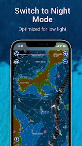
- MAP OPTIONS: Change chart-overlay combinations to customize chart views, activate night mode, highlight shallow areas, target multiple fishing ranges and more.
- DAILY UPDATES: Benefit from up to 5,000 daily updates worldwide.
• TOOLS FOR PLANNING AND ENJOYING YOUR DAY
- AUTO GUIDANCE+TM TECHNOLOGY**: Easily plan your trip with a suggested dock-to-dock path based on chart data and navigation aids. Get ETA, distance to arrival, heading to waypoint, fuel consumption and more.
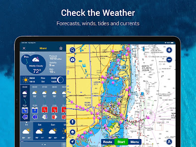
- WEATHER AND TIDES: Knowing conditions before heading out is crucial. Access real-time weather data, daily and hourly forecasts as well as wind, weather buoys, tides and currents.
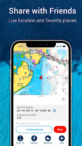
- MARKERS, TRACKS, DISTANCE: Place a marker on a good anchorage spot or where you reeled in a big fish. Record your track, take photos and videos within the app, and look back at your day anytime. Easily check distance among two points.
• AN ACTIVE AND HELPFUL COMMUNITY
- COMMUNITY EDITS and the ACTIVECAPTAIN® COMMUNITY: Obtain and contribute useful local knowledge along with thousands of fellow boaters, such as points of interest, navigation aids and valuable recommendations from people with firsthand experience of the local environment.
- CONNECTIONS: Stay in touch with your friends and fellow boaters by sharing your live location, tracks, routes and markers to easily meet on the water or let them check out your adventures.
- GPX IMPORT/EXPORT: Share your saved data outside the app or transfer it to your chartplotter.
- SHARE MAP OBJECTS: Share a marina, repair shop or any other location outside the app.
• EXTERNAL DEVICE-FRIENDLY FOR MORE FEATURES
- PLOTTER SYNC: If you own a compatible chartplotter, sync it with the app to transfer routes and markers, activate, update or renew your Navionics chartplotter card subscription.
- SONARCHART LIVE MAPPING FEATURE***: Connect with a compatible sonar/plotter, and create your own maps in real time while navigating.
- AIS: Connect to a compatible AIS receiver with Wi-Fi® connectivity to see nearby marine traffic. Set a safe range, and receive visual and aural alerts to signal potential collisions.
NOTES:
*You can manage your subscription anytime, and you can turn auto-renewal off.
**Auto Guidance+ is for planning purposes only and does not replace safe navigation operations
***Free features
The app is specifically designed to load and operate on devices with an OS of 7.0 or higher. A tablet device with Wi-Fi connectivity locates your approximate position if it is connected to Wi-Fi. A tablet Wi-Fi + 3G model operates similarly to a phone device with GPS.
Wi-Fi is a registered trademark of the Wi-Fi Alliance.
A COMPLETE PACKAGE
• INTERNATIONALLY RENOWNED NAVIONICS® CHARTS: Use them offline along with multiple overlays, so you can be more aware of what’s above and below the water.
- NAUTICAL CHART: Use this premier marine reference to study port plans, anchorages and safety depth contours, locate navaids, marine services and more.
- SONARCHART™ HD BATHYMETRY MAPS: Extraordinary 1’ (0.5 meter) HD bottom contour detail is the ideal tool for locating new fishing areas.
- U.S. GOVERNMENT CHARTS (NOAA): These are available within the following coverages: U.S. and Canada, Mexico, Caribbean to Brazil.
- OVERLAYS: The relief shading overlay allows you to have a better understanding of bottom topography for improved fishing and diving. Sonar imagery reveals bottom hardness clearly and in vivid color on select lakes. Want more? Display satellite imagery on land and water.
- MAP OPTIONS: Change chart-overlay combinations to customize chart views, activate night mode, highlight shallow areas, target multiple fishing ranges and more.
- DAILY UPDATES: Benefit from up to 5,000 daily updates worldwide.
• TOOLS FOR PLANNING AND ENJOYING YOUR DAY
- AUTO GUIDANCE+TM TECHNOLOGY**: Easily plan your trip with a suggested dock-to-dock path based on chart data and navigation aids. Get ETA, distance to arrival, heading to waypoint, fuel consumption and more.
- WEATHER AND TIDES: Knowing conditions before heading out is crucial. Access real-time weather data, daily and hourly forecasts as well as wind, weather buoys, tides and currents.
- MARKERS, TRACKS, DISTANCE: Place a marker on a good anchorage spot or where you reeled in a big fish. Record your track, take photos and videos within the app, and look back at your day anytime. Easily check distance among two points.
• AN ACTIVE AND HELPFUL COMMUNITY
- COMMUNITY EDITS and the ACTIVECAPTAIN® COMMUNITY: Obtain and contribute useful local knowledge along with thousands of fellow boaters, such as points of interest, navigation aids and valuable recommendations from people with firsthand experience of the local environment.
- CONNECTIONS: Stay in touch with your friends and fellow boaters by sharing your live location, tracks, routes and markers to easily meet on the water or let them check out your adventures.
- GPX IMPORT/EXPORT: Share your saved data outside the app or transfer it to your chartplotter.
- SHARE MAP OBJECTS: Share a marina, repair shop or any other location outside the app.
• EXTERNAL DEVICE-FRIENDLY FOR MORE FEATURES
- PLOTTER SYNC: If you own a compatible chartplotter, sync it with the app to transfer routes and markers, activate, update or renew your Navionics chartplotter card subscription.
- SONARCHART LIVE MAPPING FEATURE***: Connect with a compatible sonar/plotter, and create your own maps in real time while navigating.
- AIS: Connect to a compatible AIS receiver with Wi-Fi® connectivity to see nearby marine traffic. Set a safe range, and receive visual and aural alerts to signal potential collisions.
NOTES:
*You can manage your subscription anytime, and you can turn auto-renewal off.
**Auto Guidance+ is for planning purposes only and does not replace safe navigation operations
***Free features
The app is specifically designed to load and operate on devices with an OS of 7.0 or higher. A tablet device with Wi-Fi connectivity locates your approximate position if it is connected to Wi-Fi. A tablet Wi-Fi + 3G model operates similarly to a phone device with GPS.
Wi-Fi is a registered trademark of the Wi-Fi Alliance.
Updated on
Safety starts with understanding how developers collect and share your data. Data privacy and security practices may vary based on your use, region, and age. The developer provided this information and may update it over time.

No data shared with third parties
Learn more about how developers declare sharing

This app may collect these data types
Personal info, Financial info and 4 others

Data is encrypted in transit

You can request that data be deleted
Ratings and reviews
4.1
38.6K reviews

Steve
- Flag inappropriate
July 24, 2024
Navionics was originally a one-time purchase. I bought it for iOS and Android despite it being fairly expensive at the time. Over time, they moved to a subscription model which was also fine initially as I could still access my charts (just no advanced features like autorouting). Now they demand a subscription fee to even see the basic charts. If you aren't going to respect the terms of the initial purchase, I'll look elsewhere.
24 people found this review helpful
Garmin Italy Technologies srl
July 25, 2024
We do understand your disappointment with the recent changes to the Boating app. However, all our Terms & Conditions include the statement “Navionics reserves the right to amend periodically these CGV by publishing an updated version of the Services. You can view the full T&C using the following link. https://www.navionics.com/legal/terms-of-sales

Rob Stokes
- Flag inappropriate
- Show review history
August 1, 2024
Great app! EDIT.. While I still like the app, I can no longer afford the app as the most recent price increase is simply not in tune with reality. So long Navionics.. Edit #2. Per the "premium navigation tool .." response - maybe have a read of the reviews this price change is receiving. As an FYI, I'm not only a user, I teach Navionics, or I did. You don't need to justify the price increase to me - it's your product, price it as you see fit. My students and I are on a different platform now.
12 people found this review helpful
Garmin Italy Technologies srl
August 1, 2024
Rob-The Boating app is a premium navigation tool offering the latest technology in updates, overlays, planning & navigation. It offers the same charting experience and value as our premium chart plotter mapping products, Navionics Platinum+™ and Garmin Navionics Vision+™, at a competitive price point.

Peter Guilliatt
- Flag inappropriate
July 29, 2024
Overall the software is useful to me as a recorder of where I've been. Would be nice if the software included a speed value in the exported GPX files. There are tags available but the value is always zero, despite a speed value being shown on the screen during use. Could a new display(s) be designed to emulate a basic GPS display like the older handheld units which simply showed a position and/or range bearing to MOB/target, and/or another display showing a compass rose to MOB/target.
4 people found this review helpful
Garmin Italy Technologies srl
July 30, 2024
Peter- Currently this option is not available. We value customers’ input and can forward this suggestion to our Product Management Team for review and consideration for future enhancements for our Apps. Email help@navionics.com with SPK10977 in the subject. Include the suggestion, and an agent will gladly assist you.
What's new
Bug fixing and optimization.


