
My Track
Contient des annoncesAchats via l'appli
3,9star
12,7K avis
1M+
Téléchargements

3 ans et plus
info

À propos de l'application
My Track is a small and powerful application to keep track of your route while you go around. The quite complex functionality hides behind a very clear user interface which is easy to understand.
My Track can be very useful for all of your outdoor activities like hiking, bicycle and motorcycle touring, boating, skiing, climbing or sheer driving fun, it can also be used for business.
Have a look at all of these fancy features:
1. Record a route
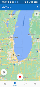
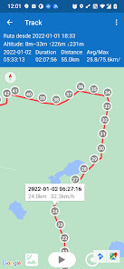
1.1 show current location on Google Map, along with time, duration and distance. even with latitude and longitude.
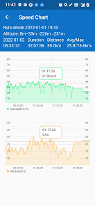
1.2 dynamic chart about speed and altitude.
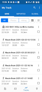
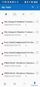
1.3 route recording, pausing, resuming, saving and listing.
1.4 photos joining with a route automatically, whatever app you use to take photos.
1.5 voice report at predefined frequency of time or distance when recording
1.6 export routes to GPX/KML/KMZ files, or import from your phone or Google Drive.
1.7 sync and restore from Google Drive.
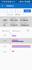
1.8 do stats.
1.9 show multi routes on the map.
1.10 print a route with the map.
2. Share a route
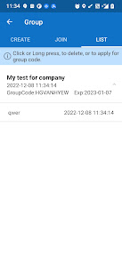
2.1 create a group and invite friends to join this group, you and your friends can share routes in this group.
2.2 share a route globally in this app.
2.3 share a route via web url to social medias, like WhatsApp, FaceBook, Gmail, etc.
2.4 select photos to share with a route.
3. Follow a route
3.1 follow your own route.
3.2 follow others’ shared route.
3.3 follow planned route.
3.4 fly your imagination: share a route in a group, friends in this group can follow this route.
4. Plan a route
4.1 plan a route(driving, bicycling and walking) among multi markers, the planed route can be followed on the map.
5. Markers
5.1 tap on the map to insert a marker, move the map to put the marker on proper position.
5.2 select markers to show on the map.
5.3 markers can be remembered to show next time when you open the app.
5.4 markers can be shared or exported within a route.
5.5 export markers to a KML file.
6. More
6.1 Live broadcast your locations to friends.
6.2 download offline map.
6.3 add map layer, and auto load this layer when the app starts.
6.4 click the map to measure distance, measure area, or to connect points to design a route line.
The app needs such permissions:
1. Storage permission for route saving.
2. Photo permission for joining photos with a route.
3. Location permission for route recording.
4. Internet permission for route sharing.
Attention:
1. Google Play and Google Maps should be installed first.
2. All basic features are free forever.
3. After 15 days you may see ads, you can pay to remove ads forever.
4. After 60 days you may subscribe to advanced features, or watch a video to get one time's feature permission.
My Track can be very useful for all of your outdoor activities like hiking, bicycle and motorcycle touring, boating, skiing, climbing or sheer driving fun, it can also be used for business.
Have a look at all of these fancy features:
1. Record a route
1.1 show current location on Google Map, along with time, duration and distance. even with latitude and longitude.
1.2 dynamic chart about speed and altitude.
1.3 route recording, pausing, resuming, saving and listing.
1.4 photos joining with a route automatically, whatever app you use to take photos.
1.5 voice report at predefined frequency of time or distance when recording
1.6 export routes to GPX/KML/KMZ files, or import from your phone or Google Drive.
1.7 sync and restore from Google Drive.
1.8 do stats.
1.9 show multi routes on the map.
1.10 print a route with the map.
2. Share a route
2.1 create a group and invite friends to join this group, you and your friends can share routes in this group.
2.2 share a route globally in this app.
2.3 share a route via web url to social medias, like WhatsApp, FaceBook, Gmail, etc.
2.4 select photos to share with a route.
3. Follow a route
3.1 follow your own route.
3.2 follow others’ shared route.
3.3 follow planned route.
3.4 fly your imagination: share a route in a group, friends in this group can follow this route.
4. Plan a route
4.1 plan a route(driving, bicycling and walking) among multi markers, the planed route can be followed on the map.
5. Markers
5.1 tap on the map to insert a marker, move the map to put the marker on proper position.
5.2 select markers to show on the map.
5.3 markers can be remembered to show next time when you open the app.
5.4 markers can be shared or exported within a route.
5.5 export markers to a KML file.
6. More
6.1 Live broadcast your locations to friends.
6.2 download offline map.
6.3 add map layer, and auto load this layer when the app starts.
6.4 click the map to measure distance, measure area, or to connect points to design a route line.
The app needs such permissions:
1. Storage permission for route saving.
2. Photo permission for joining photos with a route.
3. Location permission for route recording.
4. Internet permission for route sharing.
Attention:
1. Google Play and Google Maps should be installed first.
2. All basic features are free forever.
3. After 15 days you may see ads, you can pay to remove ads forever.
4. After 60 days you may subscribe to advanced features, or watch a video to get one time's feature permission.
Date de mise à jour
La sécurité, c'est d'abord comprendre comment les développeurs collectent et partagent vos données. Les pratiques concernant leur confidentialité et leur protection peuvent varier selon votre utilisation, votre région et votre âge. Le développeur a fourni ces informations et peut les modifier ultérieurement.

Cette appli peut partager ces types de données avec des tiers
Infos et performance des applis, Appareil ou autres ID

Cette appli peut recueillir ces types de données
Position, Informations personnelles et 4 autres

Les données sont chiffrées lors de leur transfert

Vous pouvez demander la suppression des données
Notes et avis
3,9
12,4K avis
Nouveautés
V7.1.2:
An imported route can be moved to the My Route List.
The app will prompt when more than 100 routes are all selected.
An imported route can be moved to the My Route List.
The app will prompt when more than 100 routes are all selected.


