
Guru Maps — Navigatore e Mappe
Acquisti in-app
3,7star
10.500 recensioni
1 Mln+
Download

3 anni
info


Informazioni su questa app
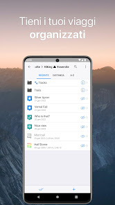
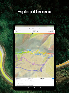
Guru Maps helps you find the best trail and spend some time enjoying the great outdoors like traveling, hiking, biking or off-roading. With detailed maps covering the entire world, offline navigation, and real time GPS tracking, you'll have everything you need to plan and organize your adventures.
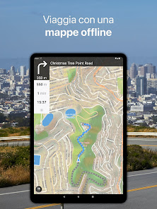
Offline Maps
• High-resolution & based on OpenStreetMap (OSM) data.
• Updated monthly with the most-recent fixes and additions.
• Adjustable font size of the labels for better readability.
• Multiple custom map layers can be shown above the base one (GeoJSON support).
• Hillshade, contour lines and slope overlays for relief visualisation.
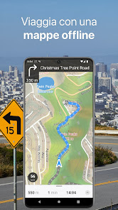
Offline Navigation
• Turn-by-turn voice-guided driving directions with alternate ways.
• Multi-stop navigation with the route optimization feature (circuit route planner).
• Voice instructions while navigating available in 9 languages.
• Routes for Driving/Cycling/Walking/Shortest Distance.
• Automatic rerouting gets you back along your way, even offline.
Drive Offroad• There is an option for choosing the type of bike to build the perfect route, given the pavement (road surface): road, city, touring, mountain (MTB), trekking or gravel bikes.
• Plan an off-road overland trip in your 4x4 vehicle (quad, ATV, UTV, SUV, jeep) or moto, relying on topographic data in order to avoid trickier terrain. Find trails, campsites, adequate gas stations and other destinations along the route, even during an offline mode.
• The trip monitor shows the orientation (compass), accurate speed in mph, km/h or knots units (speedometer), distance (odometer), bearing line and azimuth during the trip. The app collects data from multiple satellites orbiting the Earth.
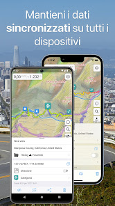
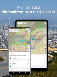
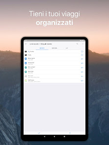
Synchronization
• Seamless sync your data across multiple iOS/Android devices as long as they are authorized with the same account.
• All the data such as saved places, recorded GPS tracks and created routes will be synced on all your devices on both OS platforms.
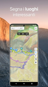
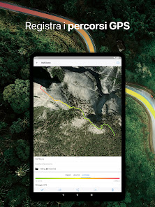
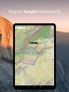
GPS Tracker
• Track the exact location of your phone & tablet real time.
• Record your footpath even when the app is in the background.
• Monitor detailed statistics of your ride: current speed, distance, time traveled, altitude.
• Choose from seven solid track colors, or altitude and speed gradients.
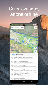
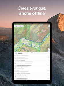
Offline Search
• Incredibly fast – results appear instantly as you type.
• Searches simultaneously in multiple languages, making searching easier than ever.
• Search in a variety of ways – by address, object name, category, or even by GPS coordinates. Supported coordinates formats: MGRS, UTM, Plus codes, DMS, latitude & longitude (decimal degrees (DD), degrees and decimal minutes, sexagesimal degree).
Online Maps
• Pre-installed online map sources: OpenCycleMap, HikeBikeMap, OpenBusMap, Wikimapia, CyclOSM, Mobile Atlas, HERE Hybrid (satellite), USGS - Topo, USGS - Satellite.
• Even more sources available for adding: OpenSeaMap, OpenTopoMap, ArcGIS, Google Maps, Bing, USGS etc from here: https://ms.gurumaps.app.
Supported File Formats
Support for a variety of file formats, including:
.GPX, .KML, .KMZ - for GPS-tracks, markers, routes or whole travel collections,
.MS, .XML - for custom map sources,
.SQLiteDB, .MBTiles - for offline raster maps,
.GeoJSON - for overlays.
PRO Subscription
• With a pro subscription, you'll have access to unlimited markers, GPS tracks, and offline map downloads, as well as additional sources and file formats.
• Without subscription it’s possible to create up to 15 pinned places, record up to 15 tracks and have only 3 vector countries (regions) downloaded on your device.
• Choose from monthly, yearly, or one-time purchase (aka lifetime license) options.
Offline Maps
• High-resolution & based on OpenStreetMap (OSM) data.
• Updated monthly with the most-recent fixes and additions.
• Adjustable font size of the labels for better readability.
• Multiple custom map layers can be shown above the base one (GeoJSON support).
• Hillshade, contour lines and slope overlays for relief visualisation.
Offline Navigation
• Turn-by-turn voice-guided driving directions with alternate ways.
• Multi-stop navigation with the route optimization feature (circuit route planner).
• Voice instructions while navigating available in 9 languages.
• Routes for Driving/Cycling/Walking/Shortest Distance.
• Automatic rerouting gets you back along your way, even offline.
Drive Offroad• There is an option for choosing the type of bike to build the perfect route, given the pavement (road surface): road, city, touring, mountain (MTB), trekking or gravel bikes.
• Plan an off-road overland trip in your 4x4 vehicle (quad, ATV, UTV, SUV, jeep) or moto, relying on topographic data in order to avoid trickier terrain. Find trails, campsites, adequate gas stations and other destinations along the route, even during an offline mode.
• The trip monitor shows the orientation (compass), accurate speed in mph, km/h or knots units (speedometer), distance (odometer), bearing line and azimuth during the trip. The app collects data from multiple satellites orbiting the Earth.
Synchronization
• Seamless sync your data across multiple iOS/Android devices as long as they are authorized with the same account.
• All the data such as saved places, recorded GPS tracks and created routes will be synced on all your devices on both OS platforms.
GPS Tracker
• Track the exact location of your phone & tablet real time.
• Record your footpath even when the app is in the background.
• Monitor detailed statistics of your ride: current speed, distance, time traveled, altitude.
• Choose from seven solid track colors, or altitude and speed gradients.
Offline Search
• Incredibly fast – results appear instantly as you type.
• Searches simultaneously in multiple languages, making searching easier than ever.
• Search in a variety of ways – by address, object name, category, or even by GPS coordinates. Supported coordinates formats: MGRS, UTM, Plus codes, DMS, latitude & longitude (decimal degrees (DD), degrees and decimal minutes, sexagesimal degree).
Online Maps
• Pre-installed online map sources: OpenCycleMap, HikeBikeMap, OpenBusMap, Wikimapia, CyclOSM, Mobile Atlas, HERE Hybrid (satellite), USGS - Topo, USGS - Satellite.
• Even more sources available for adding: OpenSeaMap, OpenTopoMap, ArcGIS, Google Maps, Bing, USGS etc from here: https://ms.gurumaps.app.
Supported File Formats
Support for a variety of file formats, including:
.GPX, .KML, .KMZ - for GPS-tracks, markers, routes or whole travel collections,
.MS, .XML - for custom map sources,
.SQLiteDB, .MBTiles - for offline raster maps,
.GeoJSON - for overlays.
PRO Subscription
• With a pro subscription, you'll have access to unlimited markers, GPS tracks, and offline map downloads, as well as additional sources and file formats.
• Without subscription it’s possible to create up to 15 pinned places, record up to 15 tracks and have only 3 vector countries (regions) downloaded on your device.
• Choose from monthly, yearly, or one-time purchase (aka lifetime license) options.
Ultimo aggiornamento
Alla base della sicurezza c'è la comprensione di come gli sviluppatori raccolgono e condividono i tuoi dati. Le misure di protezione della privacy e della sicurezza dei dati potrebbero variare in base all'utilizzo, alla regione e all'età. Lo sviluppatore ha fornito queste informazioni e potrebbe aggiornarle nel tempo.


Valutazioni e recensioni
3,8
9900 recensioni

Roberto Asirelli
- Segnala come inappropriata
29 giugno 2024
Cartografia ben fatta anche se con strade/carrareccie non aggiornate es. Strada dei Monti di Montecreto MO assente anche se è una strada bianca molto larga e trafficata. Comandi semplici ed intuitivi. Consiglio

Luigi P
- Segnala come inappropriata
31 marzo 2024
Una valida alternativa niente male, il vantaggio di poter scaricare le mappe ti permette di viaggiare anche sconnesso dalla rete, ho notato che il volume anche se portato al massimo resta un po' basso, la stò testando da poco ma sono abbastanza soddisfatto.
3 persone hanno trovato utile questa recensione

James Joshua
- Segnala come inappropriata
28 novembre 2022
Basta una minima disattenzione, uno swipe orizzontale sul percorso appena registrato, e si rischia di cancellare IRRIMEDIABILMENTE un percorso, magari importante, senza la possibilità di poterlo recuperare tramite l'inutile cestino visibile nel menù, ma assolutamente inutile sul piano pratico. Consiglio vivamente ai programmatori di questa deleteria, inutile e pericolosa app, di cambiare mestiere!!!!!
7 persone hanno trovato utile questa recensione
Evgen Bodunov
7 dicembre 2022
Grazie per la tua opinione. Mi dispiace sapere che hai avuto un'esperienza frustrante e hai perso la tua traccia registrata. Ci impegneremo a fare meglio.
Novità
In questa versione abbiamo risolto diversi bug che probabilmente non avevi nemmeno notato.
Assistenza per le app
phone
Numero di telefono
+48515124655
Info sullo sviluppatore
Evgen Bodunov
evgen@getyourmap.com
Twarda 44
00-831 Warszawa
Poland
undefined


