

Mapillary

50 Tsg.+
Downloads

Altersfreigabe ab 3 Jahren
info
Über diese App
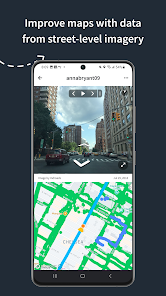
Mapillary is the street-level imagery platform that scales and automates mapping using collaboration, cameras, and computer vision.
Anyone can capture images of any place, as often as needed, with any camera—including smartphones. Mapillary combines all images into a collaborative street-level view of the world that’s available for anyone to explore and use for improving maps, cities, and mobility. Computer vision technology provides a smooth viewing experience and speeds up mapping through machine-extracted map data.
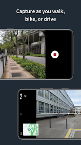
Capturing with the Mapillary mobile app is the easiest way to join our contributor network. Let’s get started!
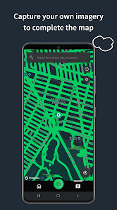
CREATE YOUR OWN STREET-LEVEL VIEWS
You control when and where to capture to create the freshest street-level imagery. Mapillary’s technology combines all images into a navigable view and blurs faces and license plates for privacy.
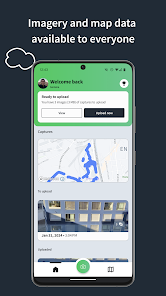
ACCESS AND OPEN UP DATA
Mapillary contributors are people, organizations, companies, and governments in 190 countries. Millions of images are added to the dataset every week, which you can explore right here in the mobile app.
MAKE BETTER MAPS
Use imagery and machine-extracted data to add details to maps and geospatial datasets. Mapillary integrates with tools like OpenStreetMap iD editor and JOSM, HERE Map Creator, and ArcGIS. To access the available map data, go to mapillary.com/app.
Anyone can capture images of any place, as often as needed, with any camera—including smartphones. Mapillary combines all images into a collaborative street-level view of the world that’s available for anyone to explore and use for improving maps, cities, and mobility. Computer vision technology provides a smooth viewing experience and speeds up mapping through machine-extracted map data.
Capturing with the Mapillary mobile app is the easiest way to join our contributor network. Let’s get started!
CREATE YOUR OWN STREET-LEVEL VIEWS
You control when and where to capture to create the freshest street-level imagery. Mapillary’s technology combines all images into a navigable view and blurs faces and license plates for privacy.
ACCESS AND OPEN UP DATA
Mapillary contributors are people, organizations, companies, and governments in 190 countries. Millions of images are added to the dataset every week, which you can explore right here in the mobile app.
MAKE BETTER MAPS
Use imagery and machine-extracted data to add details to maps and geospatial datasets. Mapillary integrates with tools like OpenStreetMap iD editor and JOSM, HERE Map Creator, and ArcGIS. To access the available map data, go to mapillary.com/app.
Aktualisiert am
Was die Sicherheit angeht, solltest du als Erstes verstehen, wie Entwickler deine Daten erheben und weitergeben. Die Datenschutz- und Sicherheitspraktiken können je nach deiner Verwendung, deiner Region und deinem Alter variieren. Diese Informationen wurden vom Entwickler zur Verfügung gestellt und können jederzeit von ihm geändert werden.

Keine Daten werden mit Drittunternehmen oder -organisationen geteilt

Diese App kann die folgenden Datentypen erheben
Standort, Personenbezogene Daten und 3 andere

Daten werden bei der Übertragung verschlüsselt

Du kannst das Löschen der Daten beantragen
Neuigkeiten
In this release we made some changes to the camera screen.
- wide angle camera support (for newer phones supporting logical multi-camera APIs)
- manual capture enabled outside of automatic capture
- toggle ON/OFF Flash and show Map on capture in Settings
- map on the Camera screen is rotating in the user facing direction
- reduced data consumption of the map on Camera screen
- volume buttons can be used to trigger capturing
- display of captured distance
- UI improvements
- Bug/Crash fixes


